

Public Health (Smoke-free Areas) Regulations 2024
I, the Governor in and over the State of Tasmania and its Dependencies in the Commonwealth of Australia, acting with the advice of the Executive Council, make the following regulations under the Public Health Act 1997 .
30 January 2024B. BAKER
Governor
By Her Excellency's Command,
GUY BARNETT
Minister for Health
These regulations may be cited as the Public Health (Smoke-free Areas) Regulations 2024 .
These regulations take effect on 12 February 2024.
In these regulations –Act means the Public Health Act 1997 .
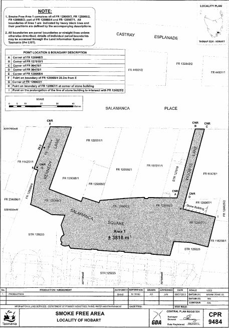
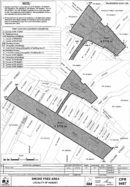
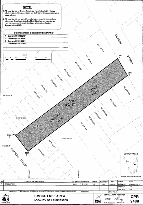
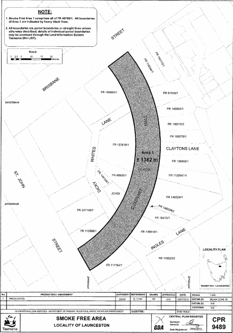
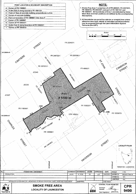
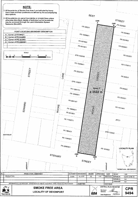
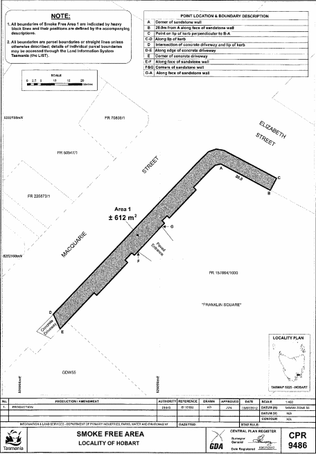
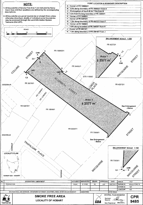
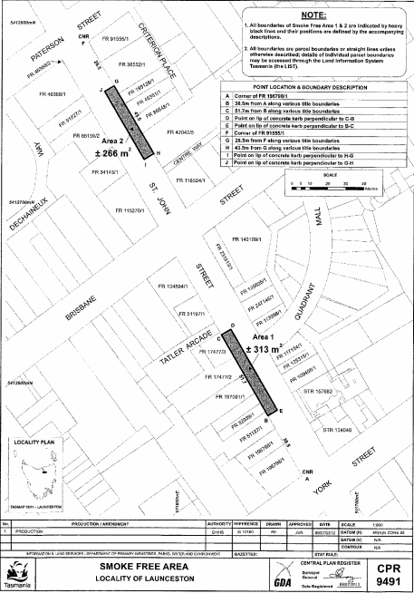
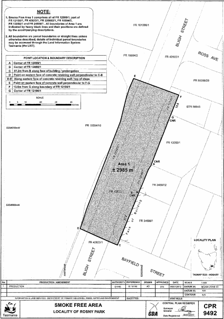
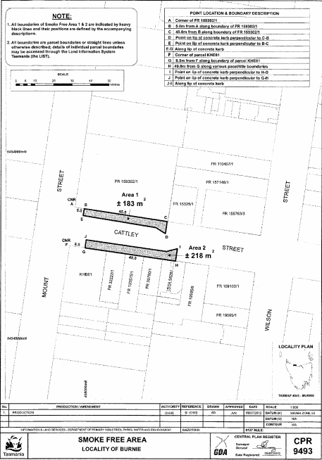
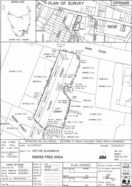
(1) For the purposes of section 67B(1)(m) of the Act, the following public streets are declared to be pedestrian malls:(a) Salamanca Square, Kennedy Lane and Woobys Lane, comprising all that area of land of about 3 818 square metres shown as Area 1, bounded by a heavy black line and shaded, on Plan 9484 in the Central Plan Register, a reduced copy of which is set out, by way of illustration only, in Part 1 of Schedule 1 ;(b) Elizabeth Mall, Soundys Lane and Wellington Court, comprising all that area of land of about 3 776 square metres shown as Area 1, bounded by a heavy black line and shaded, on Plan 9487 in the Central Plan Register, a reduced copy of which is set out, by way of illustration only, in Part 2 of Schedule 1 ;(c) Brisbane Street (The Mall), comprising all that area of land of about 2 497 square metres shown as Area 1, bounded by a heavy black line and shaded, on Plan 9488 in the Central Plan Register, a reduced copy of which is set out, by way of illustration only, in Part 3 of Schedule 1 ;(d) Quadrant Mall, comprising all that area of land of about 1 382 square metres shown as Area 1, bounded by a heavy black line and shaded, on Plan 9489 in the Central Plan Register, a reduced copy of which is set out, by way of illustration only, in Part 4 of Schedule 1 ;(e) Civic Square, comprising all that area of land of about 5 140 square metres shown as Area 1, bounded by a heavy black line and shaded, on Plan 9490 in the Central Plan Register, a reduced copy of which is set out, by way of illustration only, in Part 5 of Schedule 1 ;(f) Rooke Street, comprising all that area of land of about 3 522 square metres shown as Area 1, bounded by a heavy black line and shaded, on Plan 9494 in the Central Plan Register, a reduced copy of which is set out, by way of illustration only, in Part 6 of Schedule 1 .(2) For the purposes of section 67B(1)(n) of the Act, the following public streets are declared to be bus malls:(a) all that area of land comprising about 612 square metres shown as Area 1, bounded by a heavy black line and shaded, on Plan 9486 in the Central Plan Register, a reduced copy of which is set out, by way of illustration only, in Part 7 of Schedule 1 ;(b) Elizabeth Street, comprising all that area of land of about 2 577 square metres shown as Area 1, bounded by a heavy black line and shaded, on Plan 9485 in the Central Plan Register, a reduced copy of which is set out, by way of illustration only, in Part 8 of Schedule 1 ;(c) all those areas of land comprising about 313 square metres and 266 square metres shown as Area 1 and Area 2, respectively, bounded by heavy black lines and shaded, on Plan 9491 in the Central Plan Register, a reduced copy of which is set out, by way of illustration only, in Part 9 of Schedule 1 ;(d) all that area of land comprising about 2 985 square metres shown as Area 1, bounded by a heavy black line and shaded, on Plan 9492 in the Central Plan Register, a reduced copy of which is set out, by way of illustration only, in Part 10 of Schedule 1 ;(e) all those areas of land comprising about 183 square metres and 218 square metres shown as Area 1 and Area 2, respectively, bounded by heavy black lines and shaded, on Plan 9493 in the Central Plan Register, a reduced copy of which is set out, by way of illustration only, in Part 11 of Schedule 1 ;(f) Tolosa Street, comprising all that area of land of about 3 204 square metres shown as Lot 1, and bounded by a heavy black line, on Plan 9495 in the Central Plan Register, a reduced copy of which is set out, by way of illustration only, in Part 12 of Schedule 1 .
SCHEDULE 1 - Plans
PART 1 - Plan 9484
PART 2 - Plan 9487
PART 3 - Plan 9488
PART 4 - Plan 9489
PART 5 - Plan 9490
PART 6 - Plan 9494
PART 7 - Plan 9486
PART 8 - Plan 9485
PART 9 - Plan 9491
PART 10 - Plan 9492
PART 11 - Plan 9493
PART 12 - Plan 9495
Displayed and numbered in accordance with the Rules Publication Act 1953.
Notified in the Gazette on 7 February 2024
These regulations are administered in the Department of Health.