

Proclamation under the Nature Conservation Act 2002
I, the Governor in and over the State of Tasmania and its Dependencies in the Commonwealth of Australia, acting with the advice of the Executive Council, by this my proclamation made under section 11(2) of the Nature Conservation Act 2002 declare –
29 April 2013(a) the Crown land specified in Part 1 of Schedule 1 to this proclamation to be reserved land in the class of conservation area and give the name Burnett Point Conservation Area to that reserved land; and(b) the Crown land specified in Part 2 of Schedule 1 to this proclamation to be reserved land in the class of conservation area and give the name Duck River Conservation Area to that reserved land; and(c) the Crown land specified in Part 3 of Schedule 1 to this proclamation to be reserved land in the class of conservation area and give the name Duck River Conservation Area to that reserved land; and(d) the Crown land specified in Part 4 of Schedule 1 to this proclamation to be reserved land in the class of conservation area and give the name Duck River Conservation Area to that reserved land; and(e) the Crown land specified in Part 5 of Schedule 1 to this proclamation to be reserved land in the class of conservation area and give the name Esperance Point Conservation Area to that reserved land; and(f) the Crown land specified in Part 6 of Schedule 1 to this proclamation to be reserved land in the class of conservation area and give the name Griggs Creek Conservation Area to that reserved land; and(g) the Crown land specified in Part 7 of Schedule 1 to this proclamation to be reserved land in the class of conservation area and give the name Limekiln Creek Conservation Area to that reserved land; and(h) the Crown land specified in Part 8 of Schedule 1 to this proclamation to be reserved land in the class of conservation area and give the name Montagu Beach Conservation Area to that reserved land; and(i) the Crown land specified in Part 9 of Schedule 1 to this proclamation to be reserved land in the class of conservation area and give the name South Esk River Conservation Area to that reserved land; and(j) the Crown land specified in Part 10 of Schedule 1 to this proclamation to be reserved land in the class of conservation area and give the name South Esk River Conservation Area to that reserved land; and(k) the Crown land specified in Part 11 of Schedule 1 to this proclamation to be reserved land in the class of conservation area and give the name Tailers Bay Conservation Area to that reserved land; and(l) the Crown land specified in Part 12 of Schedule 1 to this proclamation to be reserved land in the class of conservation area and give the name Tyenna River Conservation Area to that reserved land; and(m) the Crown land specified in Part 13 of Schedule 1 to this proclamation to be reserved land in the class of conservation area and give the name Tyenna River Conservation Area to that reserved land; and(n) that this proclamation takes effect on the day on which its making is notified in the Gazette.
PETER G. UNDERWOOD
Governor
By His Excellency's Command,
BRIAN WIGHTMAN
Minister for Environment, Parks and Heritage
SCHEDULE 1 - Areas of Land
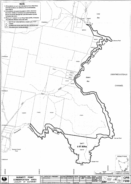
PART 1 - Burnett Point Conservation AreaAll that area of land comprising about 97.8 hectares, shown as Lot 1 and bounded by a heavy black line on Plan 7200 in the Central Plan Register, a reduced copy of which is set out, by way of illustration only, in Part 1 of Schedule 2 to this proclamation.
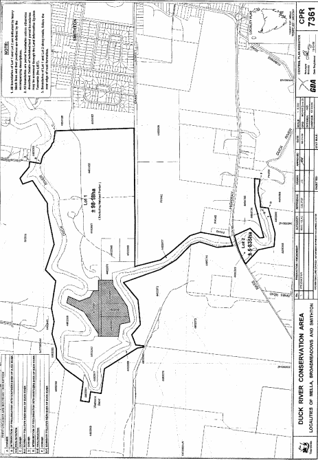
PART 2 - Duck River Conservation Area (Part 1)All that area of land, excluding the hatched portion, comprising –
bounded by heavy black lines on Plan 7361 in the Central Plan Register, a reduced copy of which is set out, by way of illustration only, in Part 2 of Schedule 2 to this proclamation.(a) about 98.18 hectares, shown as Lot 1; and(b) about 5.835 hectares, shown as Lot 2 –
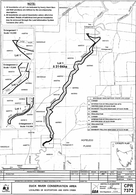
PART 3 - Duck River Conservation Area (Part 2)All that area of land comprising about 31.84 hectares, shown as Lot 1 and bounded by a heavy black line on Plan 7372 in the Central Plan Register, a reduced copy of which is set out, by way of illustration only, in Part 3 of Schedule 2 to this proclamation.
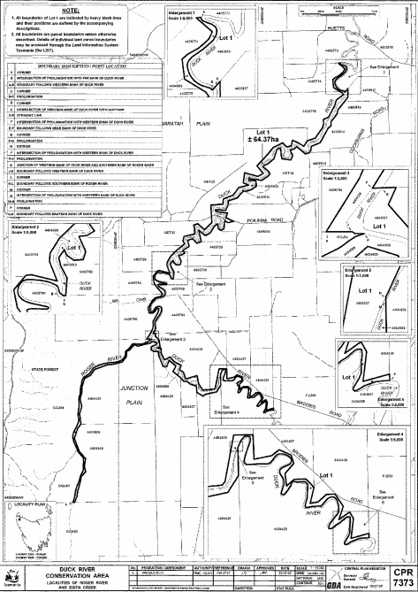
PART 4 - Duck River Conservation Area (Part 3)All that area of land comprising about 64.37 hectares, shown as Lot 1 and bounded by a heavy black line on Plan 7373 in the Central Plan Register, a reduced copy of which is set out, by way of illustration only, in Part 4 of Schedule 2 to this proclamation.
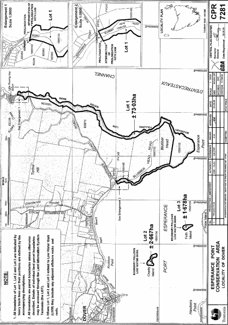
PART 5 - Esperance Point Conservation AreaAll that area of land comprising –
bounded by heavy black lines on Plan 7281 in the Central Plan Register, a reduced copy of which is set out, by way of illustration only, in Part 5 of Schedule 2 to this proclamation.(a) about 73.03 hectares, shown as Lot 1; and(b) about 2.667 hectares, shown as Lot 2; and(c) about 1.678 hectares, shown as Lot 3 –
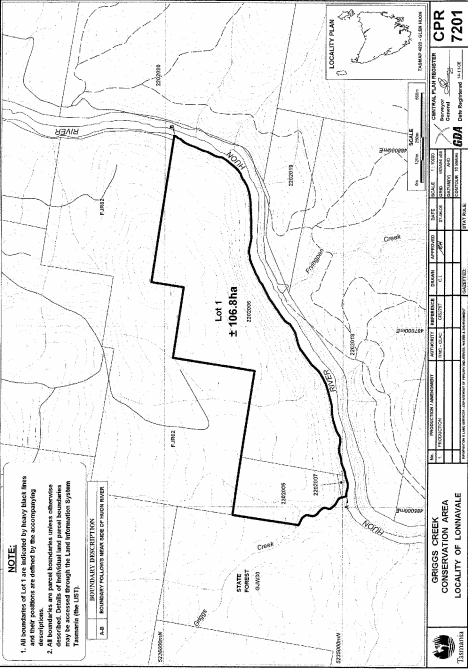
PART 6 - Griggs Creek Conservation AreaAll that area of land comprising about 106.8 hectares, shown as Lot 1 and bounded by a heavy black line on Plan 7201 in the Central Plan Register, a reduced copy of which is set out, by way of illustration only, in Part 6 of Schedule 2 to this proclamation.
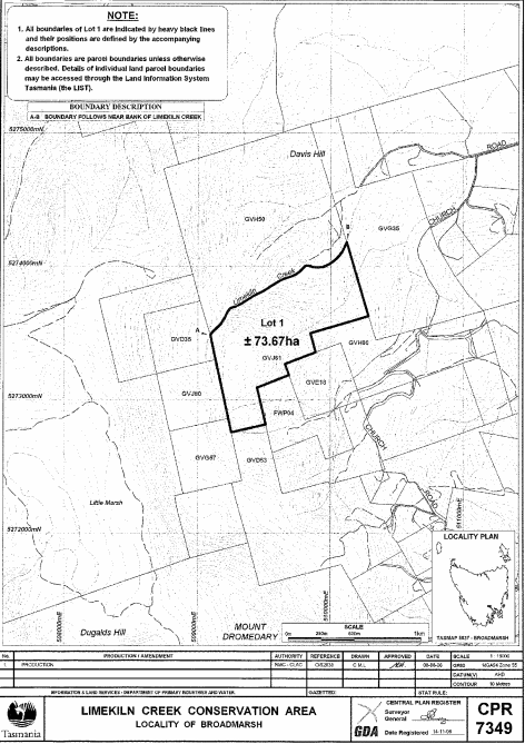
PART 7 - Limekiln Creek Conservation AreaAll that area of land comprising about 73.67 hectares, shown as Lot 1 and bounded by a heavy black line on Plan 7349 in the Central Plan Register, a reduced copy of which is set out, by way of illustration only, in Part 7 of Schedule 2 to this proclamation.
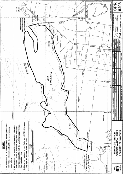
PART 8 - Montagu Beach Conservation AreaAll that area of land comprising about 298.9 hectares, shown as Lot 1 and bounded by a heavy black line on Plan 8208 in the Central Plan Register, a reduced copy of which is set out, by way of illustration only, in Part 8 of Schedule 2 to this proclamation.
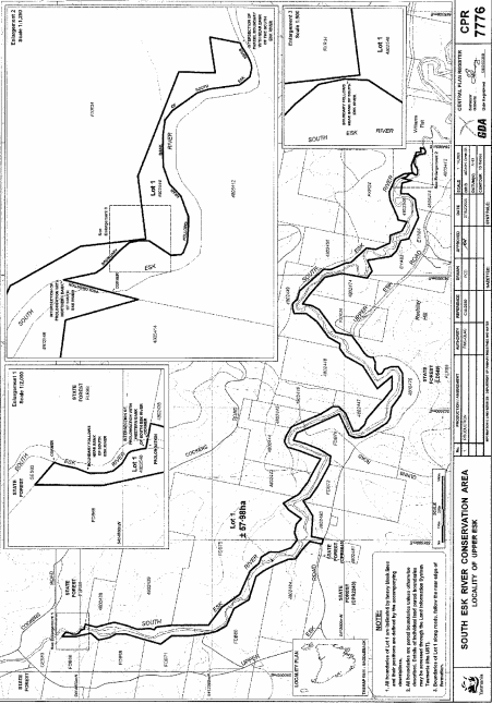
PART 9 - South Esk River Conservation Area (Part 1)All that area of land comprising about 57.98 hectares, shown as Lot 1 and bounded by a heavy black line on Plan 7776 in the Central Plan Register, a reduced copy of which is set out, by way of illustration only, in Part 9 of Schedule 2 to this proclamation.
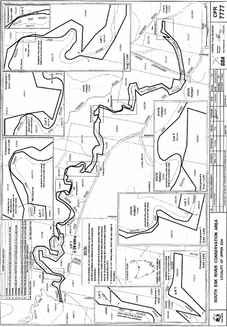
PART 10 - South Esk River Conservation Area (Part 2)All that area of land comprising about 29.89 hectares, shown as Lot 1 and bounded by a heavy black line on Plan 7777 in the Central Plan Register, a reduced copy of which is set out, by way of illustration only, in Part 10 of Schedule 2 to this proclamation.
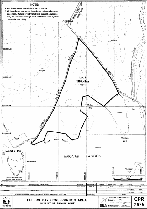
PART 11 - Tailers Bay Conservation AreaAll that area of land comprising about 105.4 hectares, shown as Lot 1 and bounded by a heavy black line on Plan 7575 in the Central Plan Register, a reduced copy of which is set out, by way of illustration only, in Part 11 of Schedule 2 to this proclamation.
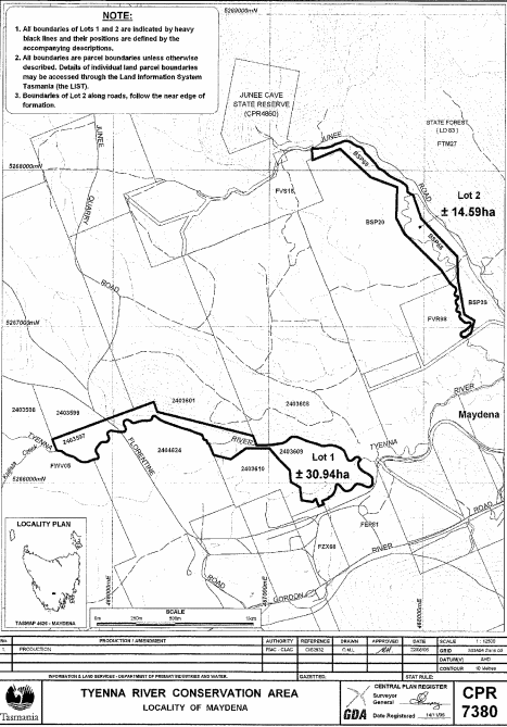
PART 12 - Tyenna River Conservation Area (Part 1)All that area of land comprising –
bounded by heavy black lines on Plan 7380 in the Central Plan Register, a reduced copy of which is set out, by way of illustration only, in Part 12 of Schedule 2 to this proclamation.(a) about 30.94 hectares, shown as Lot 1; and(b) about 14.59 hectares, shown as Lot 2 –
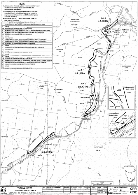
PART 13 - Tyenna River Conservation Area (Part 2)All that area of land comprising –
bounded by heavy black lines on Plan 7592 in the Central Plan Register, a reduced copy of which is set out, by way of illustration only, in Part 13 of Schedule 2 to this proclamation.(a) about 3.312 hectares, shown as Lot 1; and(b) about 8.471 hectares, shown as Lot 2; and(c) about 5.113 hectares, shown as Lot 3; and(d) about 5.03 hectares, shown as Lot 4 –
SCHEDULE 2 - Plans
PART 1 - Burnett Point Conservation Area
PART 2 - Duck River Conservation Area (Part 1)
PART 3 - Duck River Conservation Area (Part 2)
PART 4 - Duck River Conservation Area (Part 3)
PART 5 - Esperance Point Conservation Area
PART 6 - Griggs Creek Conservation Area
PART 7 - Limekiln Creek Conservation Area
PART 8 - Montagu Beach Conservation Area
PART 9 - South Esk River Conservation Area (Part 1)
PART 10 - South Esk River Conservation Area (Part 2)
PART 11 - Tailers Bay Conservation Area
PART 12 - Tyenna River Conservation Area (Part 1)
PART 13 - Tyenna River Conservation Area (Part 2)
Displayed and numbered in accordance with the Rules Publication Act 1953.
Notified in the Gazette on 8 May 2013
This proclamation is administered in the Department of Primary Industries, Parks, Water and Environment.