

Proclamation under the Nature Conservation Act 2002
I, the Governor in and over the State of Tasmania and its Dependencies in the Commonwealth of Australia, acting with the advice of the Executive Council, by this my proclamation made under section 11(2) of the Nature Conservation Act 2002 declare –
8 April 2013(a) the Crown land specified in Part 1 of Schedule 1 to this proclamation to be reserved land in the class of conservation area and give the name Ansons River Conservation Area to that reserved land; and(b) the Crown land specified in Part 2 of Schedule 1 to this proclamation to be reserved land in the class of conservation area and give the name Boobyalla River Conservation Area to that reserved land; and(c) the Crown land specified in Part 3 of Schedule 1 to this proclamation to be reserved land in the class of conservation area and give the name Brid River Conservation Area to that reserved land; and(d) the Crown land specified in Part 4 of Schedule 1 to this proclamation to be reserved land in the class of conservation area and give the name Chronicle Point Conservation Area to that reserved land; and(e) the Crown land specified in Part 5 to this proclamation to be reserved land in the class of conservation area and give the name City of Melbourne Bay Conservation Area to that reserved land; and(f) the Crown land specified in Part 6 of Schedule 1 to this proclamation to be reserved land in the class of conservation area and give the name Little Chalky Island Conservation Area to that reserved land; and(g) the Crown land specified in Part 7 of Schedule 1 to this proclamation to be reserved land in the class of conservation area and give the name North Passage Point Conservation Area to that reserved land; and(h) the Crown land specified in Part 8 of Schedule 1 to this proclamation to be reserved land in the class of conservation area and give the name Salem Bay Conservation Area to that reserved land; and(i) the Crown land specified in Part 9 of Schedule 1 to this proclamation to be reserved land in the class of conservation area and give the name Sloping Main Conservation Area to that reserved land; and(j) the Crown land specified in Part 10 of Schedule 1 to this proclamation to be reserved land in the class of conservation area and give the name Split Rock Saddle Conservation Area to that reserved land; and(k) that this proclamation takes effect on the day on which its making is notified in the Gazette.
PETER G. UNDERWOOD
Governor
By His Excellency's Command,
BRIAN WIGHTMAN
Minister for Environment, Parks and Heritage
SCHEDULE 1 - Areas of Land
PART 1 - Ansons River Conservation AreaAll that area of land comprising –
bounded by heavy black lines on Plan 7759 in the Central Plan Register, a reduced copy of which is set out, by way of illustration only, in Part 1 of Schedule 2 to this proclamation.(a) about 76.06 hectares, shown as Lot 1; and(b) about 10.92 hectares, shown as Lot 2; and(c) about 7.604 hectares, shown as Lot 3 –
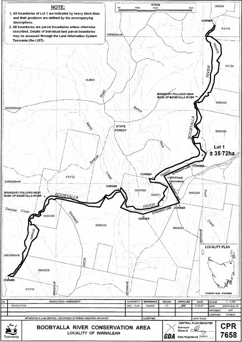
PART 2 - Boobyalla River Conservation AreaAll that area of land comprising about 35.72 hectares, shown as Lot 1 and bounded by a heavy black line on Plan 7658 in the Central Plan Register, a reduced copy of which is set out, by way of illustration only, in Part 2 of Schedule 2 to this proclamation.
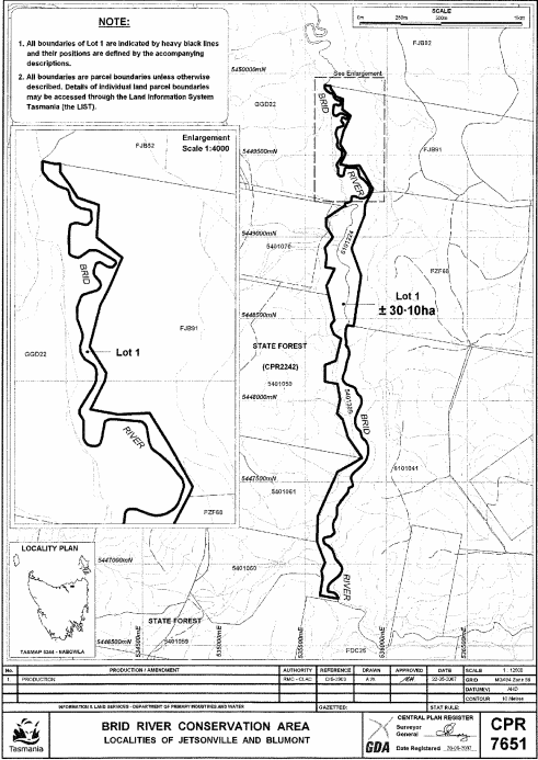
PART 3 - Brid River Conservation AreaAll that area of land comprising about 30.1 hectares, shown as Lot 1 and bounded by a heavy black line on Plan 7651 in the Central Plan Register, a reduced copy of which is set out, by way of illustration only, in Part 3 of Schedule 2 to this proclamation.
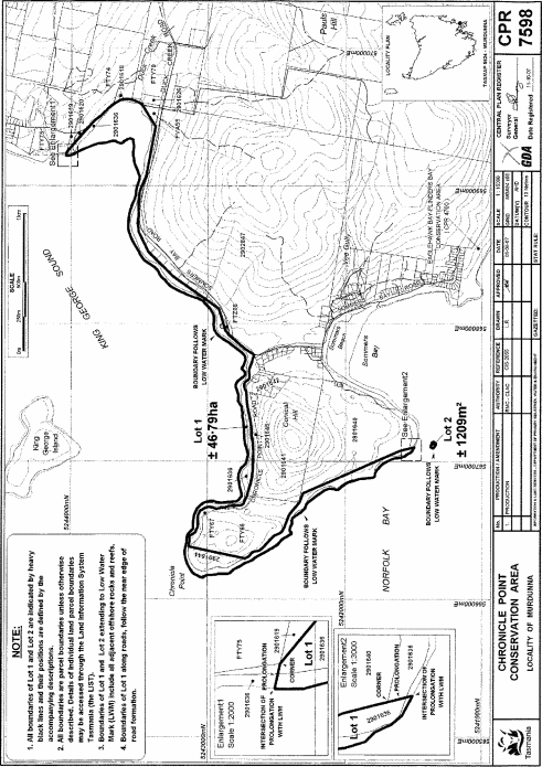
PART 4 - Chronicle Point Conservation AreaAll that area of land comprising –
bounded by heavy black lines on Plan 7598 in the Central Plan Register, a reduced copy of which is set out, by way of illustration only, in Part 4 of Schedule 2 to this proclamation.(a) about 46.79 hectares, shown as Lot 1; and(b) about 1 209 square metres, shown as Lot 2 –
PART 5 - City of Melbourne Bay Conservation AreaAll that area of land comprising about 211.1 hectares, shown as Lot 1 and bounded by a heavy black line on Plan 6918 in the Central Plan Register, a reduced copy of which is set out, by way of illustration only, in Part 5 of Schedule 2 to this proclamation.
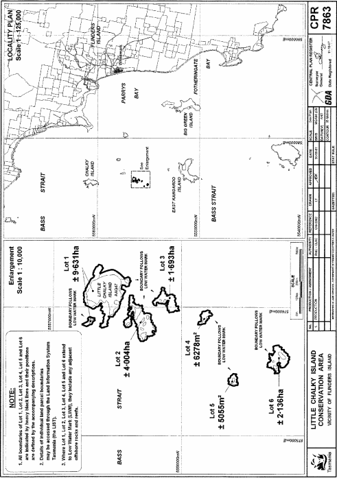
PART 6 - Little Chalky Island Conservation AreaAll that area of land comprising –
bounded by heavy black lines on Plan 7863 in the Central Plan Register, a reduced copy of which is set out, by way of illustration only, in Part 6 of Schedule 2 to this proclamation.(a) about 9.631 hectares, shown as Lot 1; and(b) about 4.004 hectares, shown as Lot 2; and(c) about 1.693 hectares, shown as Lot 3; and(d) about 6 278 square metres, shown as Lot 4; and(e) about 5 055 square metres, shown as Lot 5; and(f) about 2.136 hectares, shown as Lot 6 –
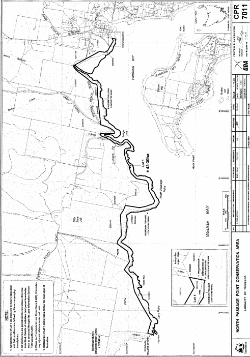
PART 7 - North Passage Point Conservation AreaAll that area of land comprising about 43.3 hectares, shown as Lot 1 and bounded by a heavy black line on Plan 7011 in the Central Plan Register, a reduced copy of which is set out, by way of illustration only, in Part 7 of Schedule 2 to this proclamation.
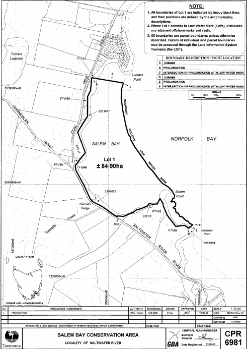
PART 8 - Salem Bay Conservation AreaAll that area of land comprising about 84.9 hectares, shown as Lot 1 and bounded by a heavy black line on Plan 6981 in the Central Plan Register, a reduced copy of which is set out, by way of illustration only, in Part 8 of Schedule 2 to this proclamation.
PART 9 - Sloping Main Conservation AreaAll that area of land comprising about 43.81 hectares, shown as Lot 1 and bounded by a heavy black line on Plan 7009 in the Central Plan Register, a reduced copy of which is set out, by way of illustration only, in Part 9 of Schedule 2 to this proclamation.
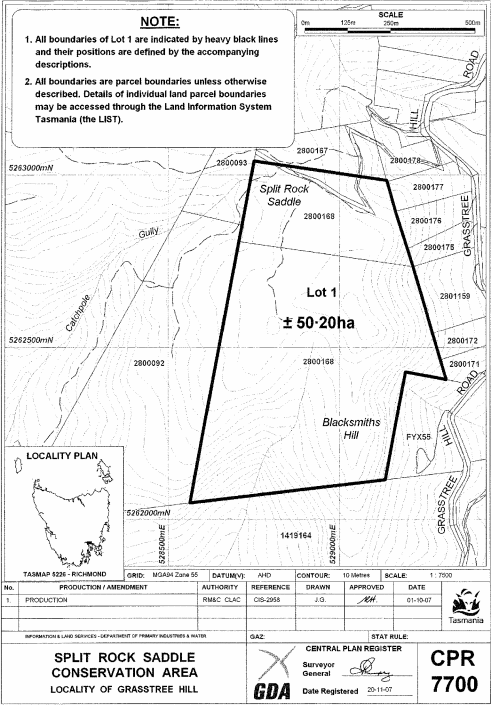
PART 10 - Split Rock Saddle Conservation AreaAll that area of land comprising about 50.2 hectares, shown as Lot 1 and bounded by a heavy black line on Plan 7700 in the Central Plan Register, a reduced copy of which is set out, by way of illustration only, in Part 10 of Schedule 2 to this proclamation.
SCHEDULE 2 - Plans
PART 1 - Ansons River Conservation Area

PART 2 - Boobyalla River Conservation Area
PART 3 - Brid River Conservation Area
PART 4 - Chronicle Point Conservation Area
PART 5 - City of Melbourne Bay Conservation Area

PART 6 - Little Chalky Island Conservation Area
PART 7 - North Passage Point Conservation Area
PART 8 - Salem Bay Conservation Area
PART 9 - Sloping Main Conservation Area

PART 10 - Split Rock Saddle Conservation Area
Displayed and numbered in accordance with the Rules Publication Act 1953.
Notified in the Gazette on 17 April 2013
This proclamation is administered in the Department of Primary Industries, Parks, Water and Environment.