

Proclamation under the Nature Conservation Act 2002
I, the Governor in and over the State of Tasmania and its Dependencies in the Commonwealth of Australia, acting with the advice of the Executive Council, by this my proclamation made under section 11(2) of the Nature Conservation Act 2002 declare –
15 October 2012(a) the Crown land specified in Part 1 of Schedule 1 to this proclamation to be reserved land in the class of conservation area and give the name Battery Island Conservation Area to that reserved land; and(b) the Crown land specified in Part 2 of Schedule 1 to this proclamation to be reserved land in the class of conservation area and give the name Bull Rock Conservation Area to that reserved land; and(c) the Crown land specified in Part 3 of Schedule 1 to this proclamation to be reserved land in the class of conservation area and give the name Darling Range Conservation Area to that reserved land; and(d) the Crown land specified in Part 4 of Schedule 1 to this proclamation to be reserved land in the class of conservation area and give the name Little Trefoil Conservation Area to that reserved land; and(e) the Crown land specified in Part 5 of Schedule 1 to this proclamation to be reserved land in the class of conservation area and give the name Nares Rocks Conservation Area to that reserved land; and(f) the Crown land specified in Part 6 of Schedule 1 to this proclamation to be reserved land in the class of conservation area and give the name Night Island Conservation Area to that reserved land; and(g) the Crown land specified in Part 7 of Schedule 1 to this proclamation to be reserved land in the class of conservation area and give the name Roger River Road Conservation Area to that reserved land; and(h) the Crown land specified in Part 8 of Schedule 1 to this proclamation to be reserved land in the class of conservation area and give the name Snake Bay Conservation Area to that reserved land; and(i) the Crown land specified in Part 9 of Schedule 1 to this proclamation to be reserved land in the class of conservation area and give the name Sugarloaf Rock Conservation Area to that reserved land; and(j) that this proclamation takes effect on the day on which its making is notified in the Gazette.
PETER G. UNDERWOOD
Governor
By His Excellency's Command,
BRIAN WIGHTMAN
Minister for Environment, Parks and Heritage
SCHEDULE 1 - Areas of Land
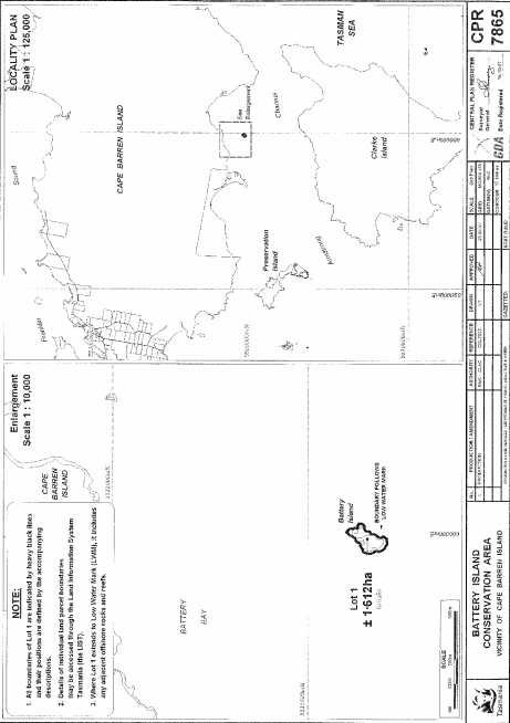
PART 1 - Battery Island Conservation AreaAll that area of land comprising about 1.612 hectares, shown as Lot 1 and bounded by a heavy black line on Plan 7865 in the Central Plan Register, a reduced copy of which is set out, by way of illustration only, in Part 1 of Schedule 2 to this proclamation.
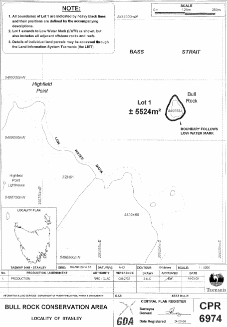
PART 2 - Bull Rock Conservation AreaAll that area of land comprising about 5 524 square metres, shown as Lot 1 and bounded by a heavy black line on Plan 6974 in the Central Plan Register, a reduced copy of which is set out, by way of illustration only, in Part 2 of Schedule 2 to this proclamation.
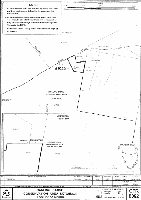
PART 3 - Darling Range Conservation AreaAll that area of land comprising about 9 222 square metres, shown as Lot 1 and bounded by a heavy black line on Plan 8062 in the Central Plan Register, a reduced copy of which is set out, by way of illustration only, in Part 3 of Schedule 2 to this proclamation.
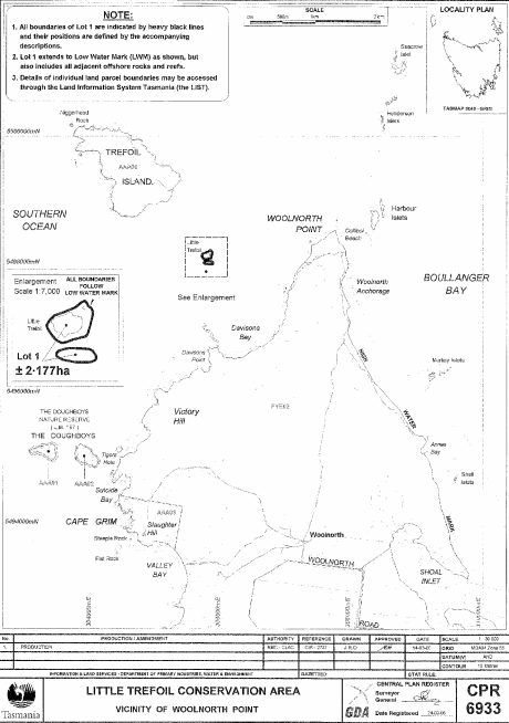
PART 4 - Little Trefoil Conservation AreaAll that area of land comprising about 2.177 hectares, shown as Lot 1 (in 2 parts) and bounded by heavy black lines on Plan 6933 in the Central Plan Register, a reduced copy of which is set out, by way of illustration only, in Part 4 of Schedule 2 to this proclamation.
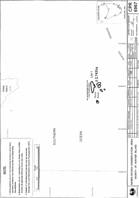
PART 5 - Nares Rocks Conservation AreaAll that area of land comprising about 2.743 hectares, shown as Lot 1 (in 6 parts) and bounded by heavy black lines on Plan 6967 in the Central Plan Register, a reduced copy of which is set out, by way of illustration only, in Part 5 of Schedule 2 to this proclamation.
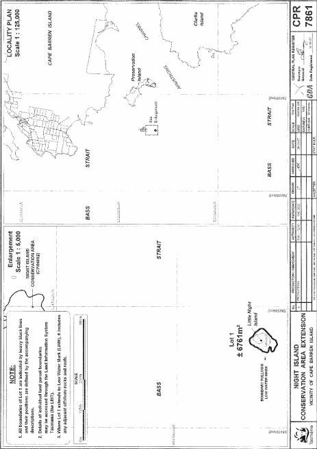
PART 6 - Night Island Conservation AreaAll that area of land comprising about 6 761 square metres, shown as Lot 1 and bounded by a heavy black line on Plan 7861 in the Central Plan Register, a reduced copy of which is set out, by way of illustration only, in Part 6 of Schedule 2 to this proclamation.
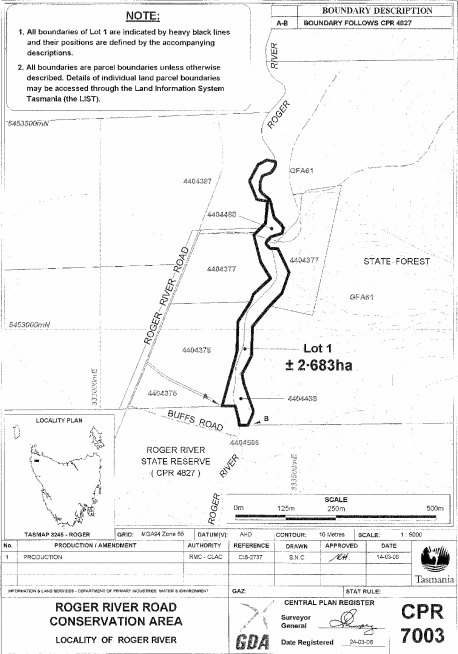
PART 7 - Roger River Road Conservation AreaAll that area of land comprising about 2.683 hectares, shown as Lot 1 and bounded by a heavy black line on Plan 7003 in the Central Plan Register, a reduced copy of which is set out, by way of illustration only, in Part 7 of Schedule 2 to this proclamation.
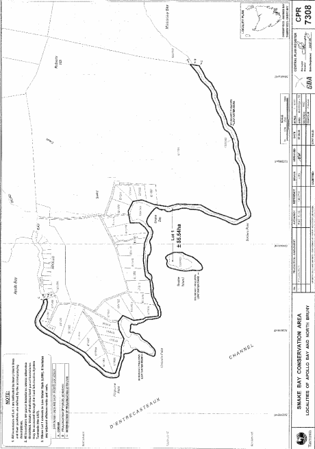
PART 8 - Snake Bay Conservation AreaAll that area of land comprising about 55.54 hectares, shown as Lot 1 (in 2 parts) and bounded by heavy black lines on Plan 7308 in the Central Plan Register, a reduced copy of which is set out, by way of illustration only, in Part 8 of Schedule 2 to this proclamation.
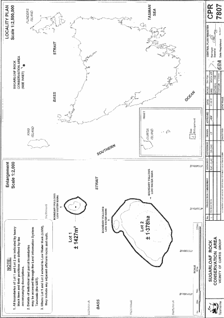
PART 9 - Sugarloaf Rock Conservation AreaAll that area of land comprising –
bounded by heavy black lines on Plan 7807 in the Central Plan Register, a reduced copy of which is set out, by way of illustration only, in Part 9 of Schedule 2 to this proclamation.(a) about 1 427 square metres, shown as Lot 1; and(b) about 1.378 hectares, shown as Lot 2 –
SCHEDULE 2 - Plans
PART 1 - Battery Island Conservation Area
PART 2 - Bull Rock Conservation Area
PART 3 - Darling Range Conservation Area
PART 4 - Little Trefoil Conservation Area
PART 5 - Nares Rocks Conservation Area
PART 6 - Night Island Conservation Area
PART 7 - Roger River Road Conservation Area
PART 8 - Snake Bay Conservation Area
PART 9 - Sugarloaf Rock Conservation Area
Displayed and numbered in accordance with the Rules Publication Act 1953.
Notified in the Gazette on 24 October 2012
This proclamation is administered in the Department of Primary Industries, Parks, Water and Environment.