

Proclamation under the Nature Conservation Act 2002
I, the Governor in and over the State of Tasmania and its Dependencies in the Commonwealth of Australia, acting with the advice of the Executive Council, by this my proclamation made under section 11(2) of the Nature Conservation Act 2002 declare –
9 July 2012(a) the Crown land specified in Part 1 of Schedule 1 to this proclamation to be reserved land in the class of conservation area and give the name Cheeseberry Hill Conservation Area to that reserved land; and(b) the Crown land specified in Part 2 of Schedule 1 to this proclamation to be reserved land in the class of conservation area and give the name Coxs Hill Conservation Area to that reserved land; and(c) the Crown land specified in Part 3 of Schedule 1 to this proclamation to be reserved land in the class of conservation area and give the name Don Heads Conservation Area to that reserved land; and(d) the Crown land specified in Part 4 of Schedule 1 to this proclamation to be reserved land in the class of conservation area and give the name Fingal Rivulet Conservation Area to that reserved land; and(e) the Crown land specified in Part 5 of Schedule 1 to this proclamation to be reserved land in the class of conservation area and give the name Medeas Cove Conservation Area to that reserved land; and(f) the Crown land specified in Part 6 of Schedule 1 to this proclamation to be reserved land in the class of conservation area and give the name River Tyne Conservation Area to that reserved land; and(g) the Crown land specified in Part 7 of Schedule 1 to this proclamation to be reserved land in the class of conservation area and give the name Royal George Conservation Area to that reserved land; and(h) the Crown land specified in Part 8 of Schedule 1 to this proclamation to be reserved land in the class of conservation area and give the name Waterhouse Conservation Area to that reserved land; and(i) that this proclamation takes effect on the day on which its making is notified in the Gazette.
PETER G. UNDERWOOD
Governor
By His Excellency's Command,
BRIAN WIGHTMAN
Minister for Environment, Parks and Heritage
SCHEDULE 1 - Areas of land
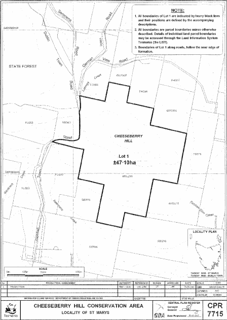
PART 1 - Cheeseberry Hill Conservation AreaAll that area of land comprising about 47.1 hectares, shown as Lot 1 and bounded by a heavy black line on Plan 7715 in the Central Plan Register, a reduced copy of which is set out, by way of illustration only, in Part 1 of Schedule 2 to this proclamation.
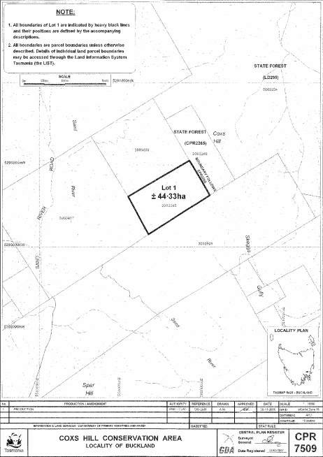
PART 2 - Coxs Hill Conservation AreaAll that area of land comprising about 44.33 hectares, shown as Lot 1 and bounded by a heavy black line on Plan 7509 in the Central Plan Register, a reduced copy of which is set out, by way of illustration only, in Part 2 of Schedule 2 to this proclamation.
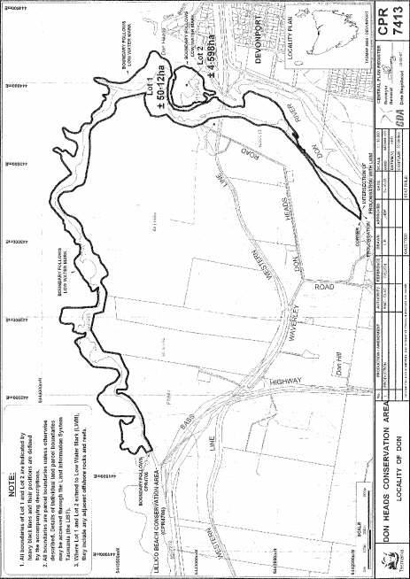
PART 3 - Don Heads Conservation AreaAll that area of land comprising –
bounded by heavy black lines on Plan 7413 in the Central Plan Register, a reduced copy of which is set out, by way of illustration only, in Part 3 of Schedule 2 to this proclamation.(a) about 50.12 hectares, shown as Lot 1; and(b) about 4.598 hectares, shown as Lot 2 –
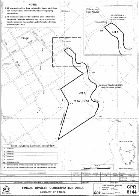
PART 4 - Fingal Rivulet Conservation AreaAll that area of land comprising about 57.62 hectares, shown as Lot 1 and bounded by a heavy black line on Plan 8144 in the Central Plan Register, a reduced copy of which is set out, by way of illustration only, in Part 4 of Schedule 2 to this proclamation.
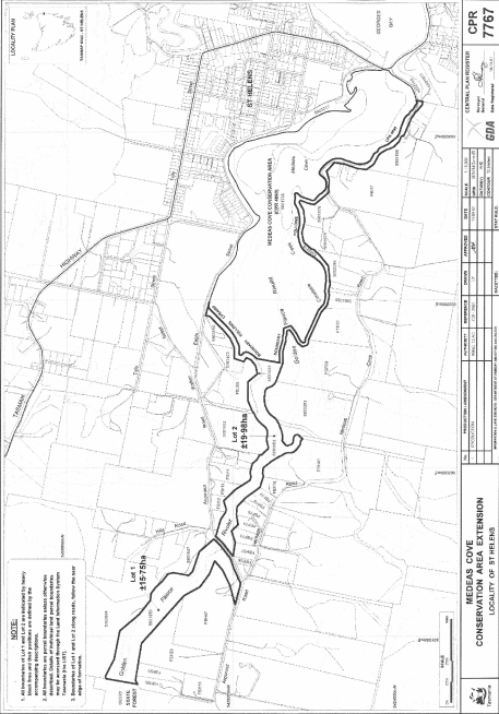
PART 5 - Medeas Cove Conservation AreaAll that area of land comprising –
bounded by heavy black lines on Plan 7767 in the Central Plan Register, a reduced copy of which is set out, by way of illustration only, in Part 5 of Schedule 2 to this proclamation.(a) about 15.75 hectares, shown as Lot 1; and(b) about 19.98 hectares, shown as Lot 2 –
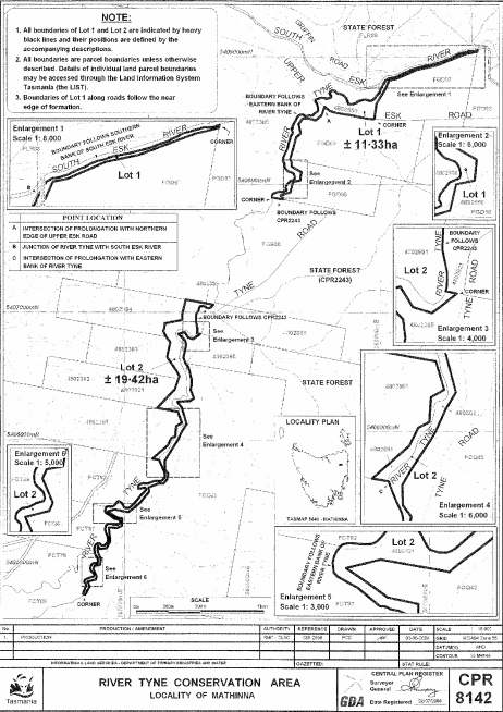
PART 6 - River Tyne Conservation AreaAll that area of land comprising –
bounded by heavy black lines on Plan 8142 in the Central Plan Register, a reduced copy of which is set out, by way of illustration only, in Part 6 of Schedule 2 to this proclamation.(a) about 11.33 hectares, shown as Lot 1; and(b) about 19.42 hectares, shown as Lot 2 –
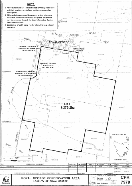
PART 7 - Royal George Conservation AreaAll that area of land comprising about 272.2 hectares, shown as Lot 1 and bounded by a heavy black line on Plan 7978 in the Central Plan Register, a reduced copy of which is set out, by way of illustration only, in Part 7 of Schedule 2 to this proclamation.
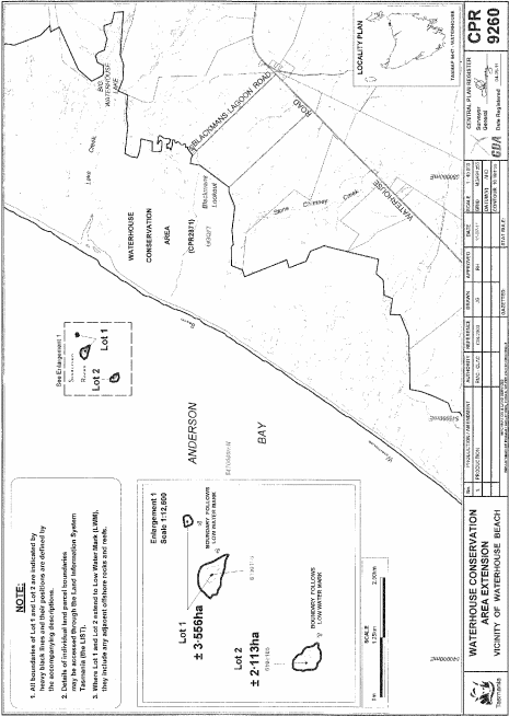
PART 8 - Waterhouse Conservation AreaAll that area of land comprising –
bounded by heavy black lines on Plan 9260 in the Central Plan Register, a reduced copy of which is set out, by way of illustration only, in Part 8 of Schedule 2 to this proclamation.(a) about 3.556 hectares, shown as Lot 1 (in 2 parts); and(b) about 2.113 hectares, shown as Lot 2 –
SCHEDULE 2 - Plans
PART 1 - Cheeseberry Hill Conservation Area
PART 2 - Coxs Hill Conservation Area
PART 3 - Don Heads Conservation Area
PART 4 - Fingal Rivulet Conservation Area
PART 5 - Medeas Cove Conservation Area
PART 6 - River Tyne Conservation Area
PART 7 - Royal George Conservation Area
PART 8 - Waterhouse Conservation Area
Displayed and numbered in accordance with the Rules Publication Act 1953.
Notified in the Gazette on 18 July 2012
This proclamation is administered in the Department of Primary Industries, Parks, Water and Environment.