

Proclamation under the Nature Conservation Act 2002
I, the Governor in and over the State of Tasmania and its Dependencies in the Commonwealth of Australia, acting with the advice of the Executive Council, by this my proclamation made under section 11(2) of the Nature Conservation Act 2002 declare –
18 June 2012(a) the Crown land specified in Part 1 of Schedule 1 to this proclamation to be reserved land in the class of conservation area and give the name Bay of Fires Conservation Area to that reserved land; and(b) the Crown land specified in Part 2 of Schedule 1 to this proclamation to be reserved land in the class of conservation area and give the name Bay of Fires Conservation Area to that reserved land; and(c) the Crown land specified in Part 3 of Schedule 1 to this proclamation to be reserved land in the class of conservation area and give the name Bay of Fires Conservation Area to that reserved land; and(d) the Crown land specified in Part 4 of Schedule 1 to this proclamation to be reserved land in the class of conservation area and give the name Bay of Fires Conservation Area to that reserved land; and(e) the Crown land specified in Part 5 of Schedule 1 to this proclamation to be reserved land in the class of conservation area and give the name Bay of Fires Conservation Area to that reserved land; and(f) the Crown land specified in Part 6 of Schedule 1 to this proclamation to be reserved land in the class of conservation area and give the name Bay of Fires Conservation Area to that reserved land; and(g) the Crown land specified in Part 7 of Schedule 1 to this proclamation to be reserved land in the class of conservation area and give the name Bluff River Conservation Area to that reserved land; and(h) the Crown land specified in Part 8 of Schedule 1 to this proclamation to be reserved land in the class of conservation area and give the name Boot Bay Conservation Area to that reserved land; and(i) the Crown land specified in Part 9 of Schedule 1 to this proclamation to be reserved land in the class of conservation area and give the name Gentle Annie Conservation Area to that reserved land; and(j) the Crown land specified in Part 10 of Schedule 1 to this proclamation to be reserved land in the class of conservation area and give the name Ninth Island Conservation Area to that reserved land; and(k) the Crown land specified in Part 11 of Schedule 1 to this proclamation to be reserved land in the class of conservation area and give the name Point Bailly Conservation Area to that reserved land; and(l) the Crown land specified in Part 12 of Schedule 1 to this proclamation to be reserved land in the class of conservation area and give the name Prosser River Conservation Area to that reserved land; and(m) the Crown land specified in Part 13 of Schedule 1 to this proclamation to be reserved land in the class of conservation area and give the name Running Ground Ridge Conservation Area to that reserved land; and(n) the Crown land specified in Part 14 of Schedule 1 to this proclamation to be reserved land in the class of conservation area and give the name Sassafras Gully Conservation Area to that reserved land; and(o) that this proclamation takes effect on the day on which its making is notified in the Gazette.
PETER G. UNDERWOOD
Governor
By His Excellency's Command,
BRIAN WIGHTMAN
Minister for Environment, Parks and Heritage
SCHEDULE 1 - Areas of land
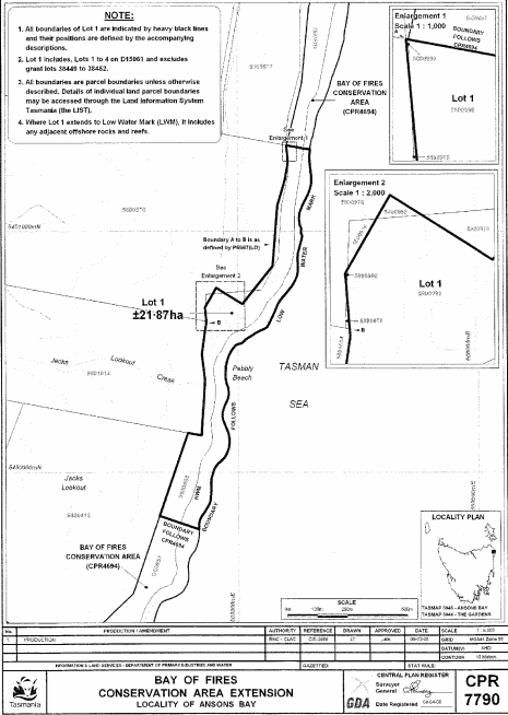
PART 1 - Bay of Fires (First Extension)All that area of land comprising about 21.87 hectares, shown as Lot 1 and bounded by a heavy black line on Plan 7790 in the Central Plan Register, a reduced copy of which is set out, by way of illustration only, in Part 1 of Schedule 2 to this proclamation.
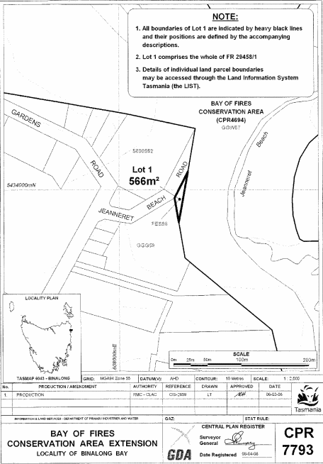
PART 2 - Bay of Fires (Second Extension)All that area of land comprising about 566 square metres, shown as Lot 1 and bounded by a heavy black line on Plan 7793 in the Central Plan Register, a reduced copy of which is set out, by way of illustration only, in Part 2 of Schedule 2 to this proclamation.
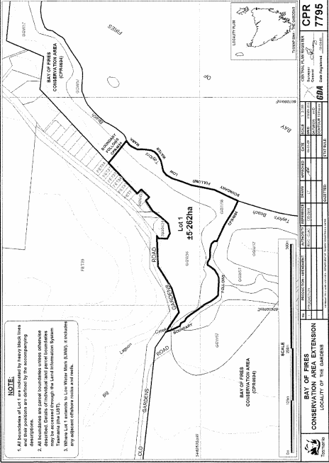
PART 3 - Bay of Fires (Third Extension)All that area of land comprising about 5.262 hectares, shown as Lot 1 and bounded by a heavy black line on Plan 7795 in the Central Plan Register, a reduced copy of which is set out, by way of illustration only, in Part 3 of Schedule 2 to this proclamation.
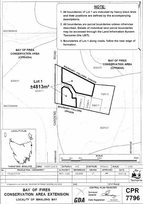
PART 4 - Bay of Fires (Fourth Extension)All that area of land comprising about 4 813 square metres, shown as Lot 1 (in 2 parts) and bounded by heavy black lines on Plan 7796 in the Central Plan Register, a reduced copy of which is set out, by way of illustration only, in Part 4 of Schedule 2 to this proclamation.
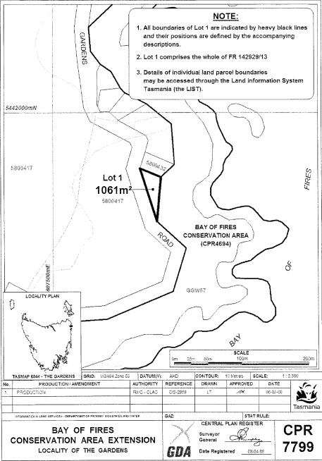
PART 5 - Bay of Fires (Fifth Extension)All that area of land comprising about 1 061 square metres, shown as Lot 1 and bounded by a heavy black line on Plan 7799 in the Central Plan Register, a reduced copy of which is set out, by way of illustration only, in Part 5 of Schedule 2 to this proclamation.
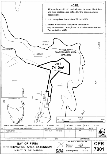
PART 6 - Bay of Fires (Sixth Extension)All that area of land comprising about 7 410 square metres, shown as Lot 1 and bounded by a heavy black line on Plan 7801 in the Central Plan Register, a reduced copy of which is set out, by way of illustration only, in Part 6 of Schedule 2 to this proclamation.
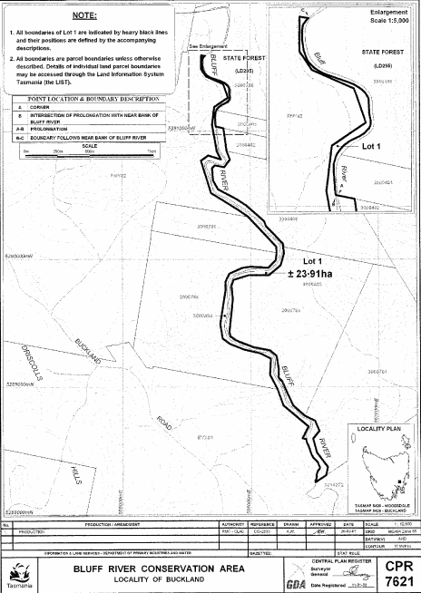
PART 7 - Bluff River Conservation AreaAll that area of land comprising about 23.91 hectares, shown as Lot 1 and bounded by a heavy black line on Plan 7621 in the Central Plan Register, a reduced copy of which is set out, by way of illustration only, in Part 7 of Schedule 2 to this proclamation.
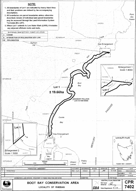
PART 8 - Boot Bay Conservation AreaAll that area of land comprising about 19.66 hectares, shown as Lot 1 and bounded by a heavy black line on Plan 7402 in the Central Plan Register, a reduced copy of which is set out, by way of illustration only, in Part 8 of Schedule 2 to this proclamation.
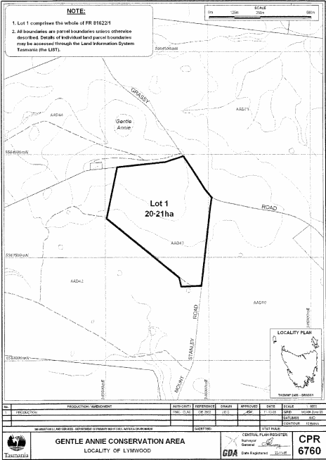
PART 9 - Gentle Annie Conservation AreaAll that area of land comprising about 20.21 hectares, shown as Lot 1 and bounded by a heavy black line on Plan 6760 in the Central Plan Register, a reduced copy of which is set out, by way of illustration only, in Part 9 of Schedule 2 to this proclamation.
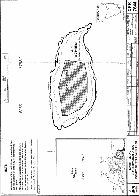
PART 10 - Ninth Island Conservation AreaAll that area of land comprising about 26.45 hectares, shown as Lot 1 (excluding the hatched portion) and bounded by a heavy black line on Plan 7644 in the Central Plan Register, a reduced copy of which is set out, by way of illustration only, in Part 10 of Schedule 2 to this proclamation.
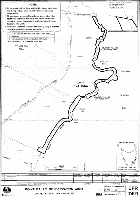
PART 11 - Point Bailly Conservation AreaAll that area of land comprising about 24.15 hectares, shown as Lot 1 and bounded by a heavy black line on Plan 7401 in the Central Plan Register, a reduced copy of which is set out, by way of illustration only, in Part 11 of Schedule 2 to this proclamation.
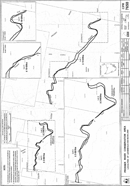
PART 12 - Prosser River Conservation AreaAll that area of land comprising –
bounded by heavy black lines on Plan 7650 in the Central Plan Register, a reduced copy of which is set out, by way of illustration only, in Part 12 of Schedule 2 to this proclamation.(a) about 19.69 hectares, shown as Lot 1; and(b) about 2.683 hectares, shown as Lot 2; and(c) about 3.061 hectares, shown as Lot 3 –
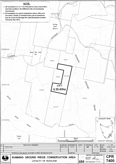
PART 13 - Running Ground Ridge Conservation AreaAll that area of land comprising about 25.43 hectares, shown as Lot 1 and bounded by a heavy black line on Plan 7400 in the Central Plan Register, a reduced copy of which is set out, by way of illustration only, in Part 13 of Schedule 2 to this proclamation.
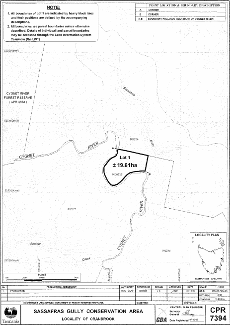
PART 14 - Sassafras Gully Conservation AreaAll that area of land comprising about 19.61 hectares, shown as Lot 1 and bounded by a heavy black line on Plan 7394 in the Central Plan Register, a reduced copy of which is set out, by way of illustration only, in Part 14 of Schedule 2 to this proclamation.
SCHEDULE 2 - Plans
PART 1 - Bay of Fires (First Extension)
PART 2 - Bay of Fires (Second Extension)
PART 3 - Bay of Fires (Third Extension)
PART 4 - Bay of Fires (Fourth Extension)
PART 5 - Bay of Fires (Fifth Extension)
PART 6 - Bay of Fires (Sixth Extension)
PART 7 - Bluff River Conservation Area
PART 8 - Boot Bay Conservation Area
PART 9 - Gentle Annie Conservation Area
PART 10 - Ninth Island Conservation Area
PART 11 - Point Bailly Conservation Area
PART 12 - Prosser River Conservation Area
PART 13 - Running Ground Ridge Conservation Area
PART 14 - Sassafras Gully Conservation Area
Displayed and numbered in accordance with the Rules Publication Act 1953.
Notified in the Gazette on 27 June 2012
This proclamation is administered in the Department of Primary Industries, Parks, Water and Environment.