

Proclamation under the Nature Conservation Act 2002
I, the Governor in and over the State of Tasmania and its Dependencies in the Commonwealth of Australia, acting with the advice of the Executive Council, by this my proclamation made under section 11(2) of the Nature Conservation Act 2002 declare –
21 November 2011(a) the Crown land specified in Part 1 of Schedule 1 to this proclamation to be reserved land in the class of conservation area and give the name Bligh Point Conservation Area to that reserved land; and(b) the Crown land specified in Part 2 of Schedule 1 to this proclamation to be reserved land in the class of conservation area and give the name Cone Islet Conservation Area to that reserved land; and(c) the Crown land specified in Part 3 of Schedule 1 to this proclamation to be reserved land in the class of conservation area and give the name Little Green Island Conservation Area to that reserved land; and(d) the Crown land specified in Part 4 of Schedule 1 to this proclamation to be reserved land in the class of conservation area and give the name Little Island Conservation Area to that reserved land; and(e) the Crown land specified in Part 5 of Schedule 1 to this proclamation to be reserved land in the class of conservation area and give the name Neds Reef Conservation Area to that reserved land; and(f) the Crown land specified in Part 6 of Schedule 1 to this proclamation to be reserved land in the class of conservation area and give the name Ram Island Conservation Area to that reserved land; and(g) the Crown land specified in Part 7 of Schedule 1 to this proclamation to be reserved land in the class of conservation area and give the name Seagull Islet Conservation Area to that reserved land; and(h) the Crown land specified in Part 8 of Schedule 1 to this proclamation to be reserved land in the class of conservation area and give the name Spike Island Conservation Area to that reserved land; and(i) the Crown land specified in Part 9 of Schedule 1 to this proclamation to be reserved land in the class of conservation area and give the name Strickland Conservation Area to that reserved land; and(j) the Crown land specified in Part 10 of Schedule 1 to this proclamation to be reserved land in the class of conservation area and give the name Tully River Conservation Area to that reserved land; and(k) that this proclamation takes effect on the day on which its making is notified in the Gazette.
PETER G. UNDERWOOD
Governor
By His Excellency's Command,
BRIAN WIGHTMAN
Minister for Environment, Parks and Heritage
SCHEDULE 1 - Areas of Land
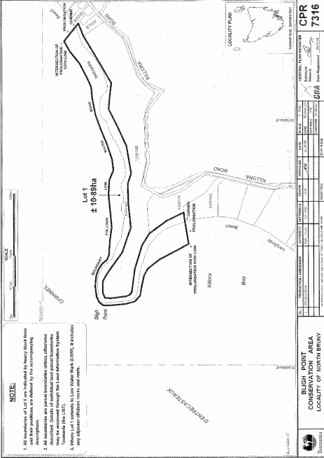
PART 1 - Bligh Point Conservation AreaAll that area of land comprising about 10.89 hectares, shown as Lot 1 and bounded by a heavy black line on Plan 7316 in the Central Plan Register, a reduced copy of which is set out, by way of illustration only, in Part 1 of Schedule 2 to this proclamation.
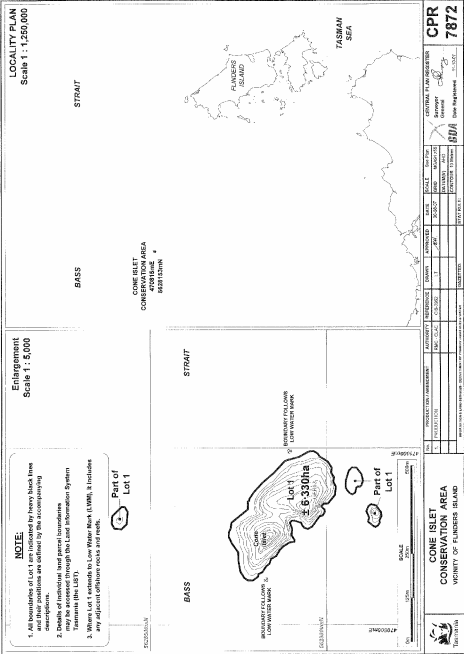
PART 2 - Cone Islet Conservation AreaAll that area of land comprising about 6.33 hectares (in 4 parts), shown as Lot 1 and bounded by heavy black lines on Plan 7872 in the Central Plan Register, a reduced copy of which is set out, by way of illustration only, in Part 2 of Schedule 2 to this proclamation.
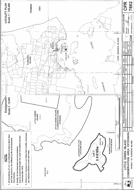
PART 3 - Little Green Island Conservation AreaAll that area of land comprising about 5.616 hectares, shown as Lot 1 and bounded by a heavy black line on Plan 7862 in the Central Plan Register, a reduced copy of which is set out, by way of illustration only, in Part 3 of Schedule 2 to this proclamation.
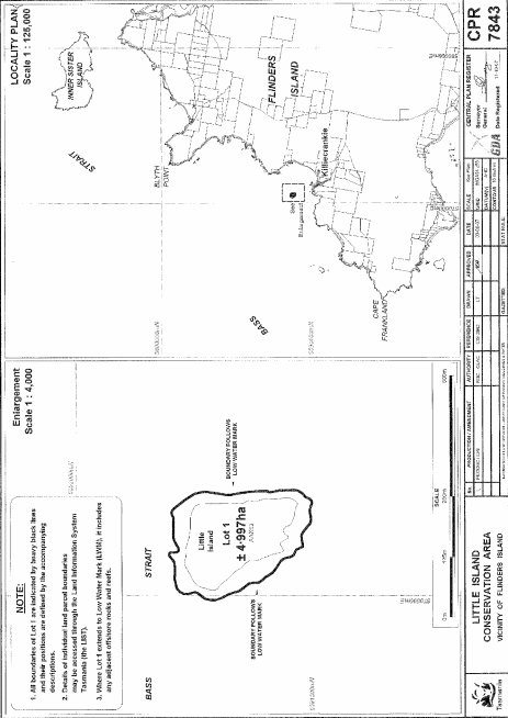
PART 4 - Little Island Conservation AreaAll that area of land comprising about 4.997 hectares, shown as Lot 1 and bounded by a heavy black line on Plan 7843 in the Central Plan Register, a reduced copy of which is set out, by way of illustration only, in Part 4 of Schedule 2 to this proclamation.
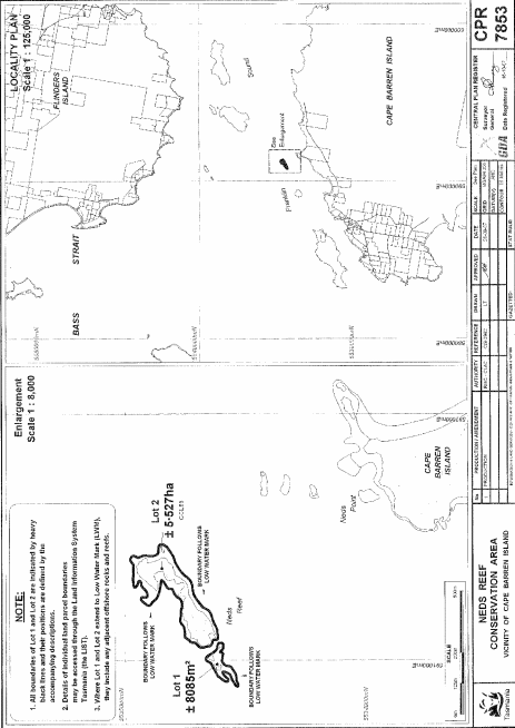
PART 5 - Neds Reef Conservation AreaAll that area of land comprising –
bounded by heavy black lines on Plan 7853 in the Central Plan Register, a reduced copy of which is set out, by way of illustration only, in Part 5 of Schedule 2 to this proclamation.(a) about 8 085 square metres, shown as Lot 1; and(b) about 5.527 hectares, shown as Lot 2 –
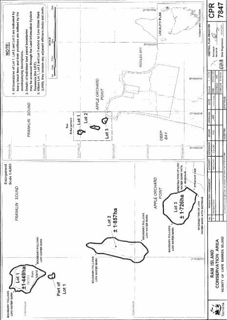
PART 6 - Ram Island Conservation AreaAll that area of land comprising –
bounded by heavy black lines on Plan 7847 in the Central Plan Register, a reduced copy of which is set out, by way of illustration only, in Part 6 of Schedule 2 to this proclamation.(a) about 1.449 hectares, shown as Lot 1 (in 2 parts); and(b) about 1.857 hectares, shown as Lot 2; and(c) about 1.726 hectares, shown as Lot 3 –
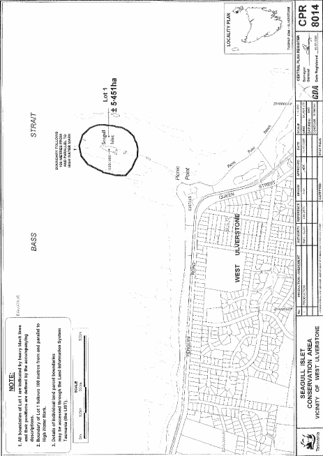
PART 7 - Seagull Islet Conservation AreaAll that area of land comprising about 5.451 hectares, shown as Lot 1 and bounded by a heavy black line on Plan 8014 in the Central Plan Register, a reduced copy of which is set out, by way of illustration only, in Part 7 of Schedule 2 to this proclamation.
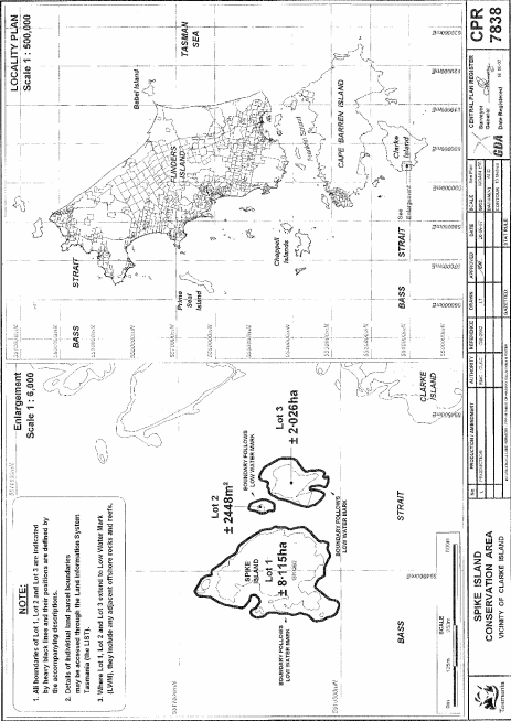
PART 8 - Spike Island Conservation AreaAll that area of land comprising –
bounded by heavy black lines on Plan 7838 in the Central Plan Register, a reduced copy of which is set out, by way of illustration only, in Part 8 of Schedule 2 to this proclamation.(a) about 8.115 hectares, shown as Lot 1; and(b) about 2 448 square metres, shown as Lot 2; and(c) about 2.026 hectares, shown as Lot 3 –
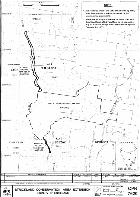
PART 9 - Strickland Conservation AreaAll that area of land comprising –
bounded by heavy black lines on Plan 7620 in the Central Plan Register, a reduced copy of which is set out, by way of illustration only, in Part 9 of Schedule 2 to this proclamation.(a) about 8.947 hectares, shown as Lot 1; and(b) about 9 532 square metres, shown as Lot 2 –
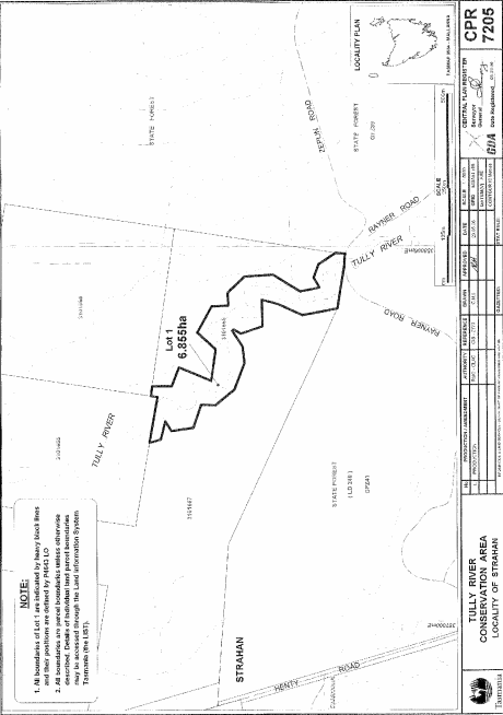
PART 10 - Tully River Conservation AreaAll that area of land comprising about 6.855 hectares, shown as Lot 1 and bounded by a heavy black line on Plan 7205 in the Central Plan Register, a reduced copy of which is set out, by way of illustration only, in Part 10 of Schedule 2 to this proclamation.
SCHEDULE 2 - Plans
PART 1 - Bligh Point Conservation Area
PART 2 - Cone Islet Conservation Area
PART 3 - Little Green Island Conservation Area
PART 4 - Little Island Conservation Area
PART 5 - Neds Reef Conservation Area
PART 6 - Ram Island Conservation Area
PART 7 - Seagull Islet Conservation Area
PART 8 - Spike Island Conservation Area
PART 9 - Strickland Conservation Area
PART 10 - Tully River Conservation Area
Displayed and numbered in accordance with the Rules Publication Act 1953.
Notified in the Gazette on 30 November 2011
This proclamation is administered in the Department of Primary Industries, Parks, Water and Environment.