

Proclamation under the Nature Conservation Act 2002
I, the Governor in and over the State of Tasmania and its Dependencies in the Commonwealth of Australia, acting with the advice of the Executive Council, by this my proclamation made under section 11(2) of the Nature Conservation Act 2002 declare –
21 November 2011(a) the Crown land specified in Part 1 of Schedule 1 to this proclamation to be reserved land in the class of conservation area and give the name Boxen Island Conservation Area to that reserved land; and(b) the Crown land specified in Part 2 of Schedule 1 to this proclamation to be reserved land in the class of conservation area and give the name Brick Islands Conservation Area to that reserved land; and(c) the Crown land specified in Part 3 of Schedule 1 to this proclamation to be reserved land in the class of conservation area and give the name Great Western Tiers Conservation Area to that reserved land; and(d) the Crown land specified in Part 4 of Schedule 1 to this proclamation to be reserved land in the class of conservation area and give the name Great Western Tiers Conservation Area to that reserved land; and(e) the Crown land specified in Part 5 of Schedule 1 to this proclamation to be reserved land in the class of conservation area and give the name Gunns Plains Conservation Area to that reserved land; and(f) the Crown land specified in Part 6 of Schedule 1 to this proclamation to be reserved land in the class of conservation area and give the name Harbour Islets Conservation Area to that reserved land; and(g) the Crown land specified in Part 7 of Schedule 1 to this proclamation to be reserved land in the class of conservation area and give the name Marriott Reef Conservation Area to that reserved land; and(h) the Crown land specified in Part 8 of Schedule 1 to this proclamation to be reserved land in the class of conservation area and give the name Mount Hicks Road Conservation Area to that reserved land; and(i) the Crown land specified in Part 9 of Schedule 1 to this proclamation to be reserved land in the class of conservation area and give the name Murkay Islets Conservation Area to that reserved land; and(j) the Crown land specified in Part 10 of Schedule 1 to this proclamation to be reserved land in the class of conservation area and give the name Sentinel Island Conservation Area to that reserved land; and(k) the Crown land specified in Part 11 of Schedule 1 to this proclamation to be reserved land in the class of conservation area and give the name Trousers Point Beach Conservation Area to that reserved land; and(l) that this proclamation takes effect on the day on which its making is notified in the Gazette.
PETER G. UNDERWOOD
Governor
By His Excellency's Command,
BRIAN WIGHTMAN
Minister for Environment, Parks and Heritage
SCHEDULE 1 - Areas of Land
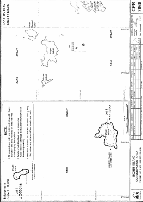
PART 1 - Boxen Island Conservation AreaAll that area of land comprising –
bounded by heavy black lines on Plan 7869 in the Central Plan Register, a reduced copy of which is set out, by way of illustration only, in Part 1 of Schedule 2 to this proclamation.(a) about 2.55 hectares, shown as Lot 1; and(b) about 11.08 hectares, shown as Lot 2 –
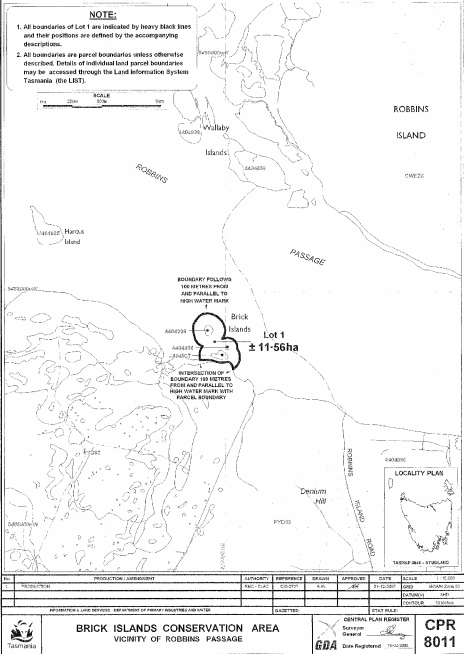
PART 2 - Brick Islands Conservation AreaAll that area of land comprising about 11.56 hectares, shown as Lot 1, and bounded by a heavy black line on Plan 8011 in the Central Plan Register, a reduced copy of which is set out, by way of illustration only, in Part 2 of Schedule 2 to this proclamation.
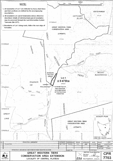
PART 3 - Great Western Tiers Conservation Area (First Extension)All that area of land comprising about 5.475 hectares, shown as Lot 1 and bounded by a heavy black line on Plan 7703 in the Central Plan Register, a reduced copy of which is set out, by way of illustration only, in Part 3 of Schedule 2 to this proclamation.
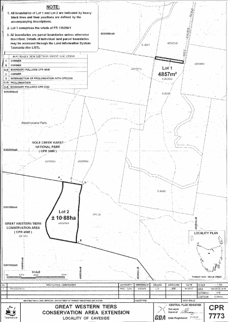
PART 4 - Great Western Tiers Conservation Area (Second Extension)All that area of land comprising –
bounded by heavy black lines on Plan 7773 in the Central Plan Register, a reduced copy of which is set out, by way of illustration only, in Part 4 of Schedule 2 to this proclamation.(a) about 4 857 square metres, shown as Lot 1; and(b) about 10.88 hectares, shown as Lot 2 –
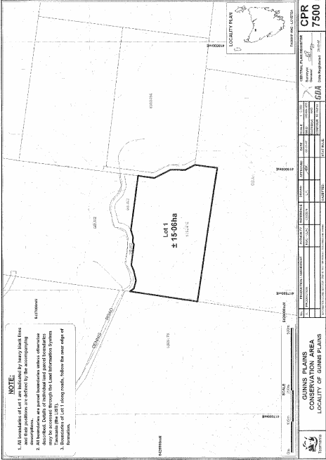
PART 5 - Gunns Plains Conservation AreaAll that area of land comprising about 15.06 hectares, shown as Lot 1 and bounded by a heavy black line on Plan 7500 in the Central Plan Register, a reduced copy of which is set out, by way of illustration only, in Part 5 of Schedule 2 to this proclamation.
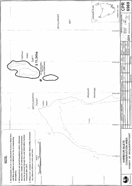
PART 6 - Harbour Islets Conservation AreaAll that area of land comprising about 11.34 hectares, shown as Lot 1 (in 3 parts) and bounded by heavy black lines on Plan 6969 in the Central Plan Register, a reduced copy of which is set out, by way of illustration only, in Part 6 of Schedule 2 to this proclamation.
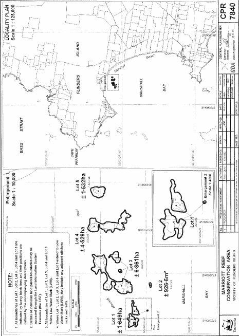
PART 7 - Marriott Reef Conservation AreaAll that area of land comprising –
bounded by heavy black lines on Plan 7840 in the Central Plan Register, a reduced copy of which is set out, by way of illustration only, in Part 7 of Schedule 2 to this proclamation.(a) about 1.649 hectares, shown as Lot 1 (in 3 parts); and(b) about 926.6 square metres, shown as Lot 2; and(c) about 6.861 hectares, shown as Lot 3 (in 3 parts); and(d) about 4.529 hectares, shown as Lot 4; and(e) about 1.532 hectares, shown as Lot 5 –
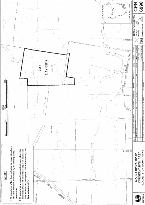
PART 8 - Mount Hicks Road Conservation AreaAll that area of land comprising about 12.63 hectares, shown as Lot 1 and bounded by a heavy black line on Plan 6990 in the Central Plan Register, a reduced copy of which is set out, by way of illustration only, in Part 8 of Schedule 2 to this proclamation.
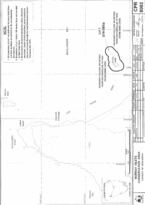
PART 9 - Murkay Islets Conservation AreaAll that area of land comprising about 14.06 hectares, shown as Lot 1 and bounded by a heavy black line on Plan 8002 in the Central Plan Register, a reduced copy of which is set out, by way of illustration only, in Part 9 of Schedule 2 to this proclamation.
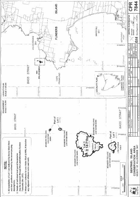
PART 10 - Sentinel Island Conservation AreaAll that area of land comprising about 14.71 hectares, shown as Lot 1 (in 4 parts) and bounded by heavy black lines on Plan 7844 in the Central Plan Register, a reduced copy of which is set out, by way of illustration only, in Part 10 of Schedule 2 to this proclamation.
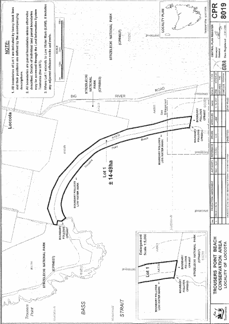
PART 11 - Trousers Point Beach Conservation AreaAll that area of land comprising about 14.49 hectares, shown as Lot 1 and bounded by a heavy black line on Plan 8019 in the Central Plan Register, a reduced copy of which is set out, by way of illustration only, in Part 11 of Schedule 2 to this proclamation.
SCHEDULE 2 - Plans
PART 1 - Boxen Island Conservation Area
PART 2 - Brick Islands Conservation Area
PART 3 - Great Western Tiers Conservation Area (First Extension)
PART 4 - Great Western Tiers Conservation Area (Second Extension)
PART 5 - Gunns Plains Conservation Area
PART 6 - Harbour Islets Conservation Area
PART 7 - Marriott Reef Conservation Area
PART 8 - Mount Hicks Road Conservation Area
PART 9 - Murkay Islets Conservation Area
PART 10 - Sentinel Island Conservation Area
PART 11 - Trousers Point Beach Conservation Area
Displayed and numbered in accordance with the Rules Publication Act 1953.
Notified in the Gazette on 30 November 2011
This proclamation is administered in the Department of Primary Industries, Parks, Water and Environment.