

Proclamation under the Nature Conservation Act 2002
I, the Governor in and over the State of Tasmania and its Dependencies in the Commonwealth of Australia, acting with the advice of the Executive Council, by this my proclamation made under section 11(2) of the Nature Conservation Act 2002 declare –
7 November 2011(a) the area of Crown land specified in Part 1 of Schedule 1 to this proclamation to be reserved land in the class of conservation area and give the name Arthur River Conservation Area to that reserved land; and(b) the area of Crown land specified in Part 2 of Schedule 1 to this proclamation to be reserved land in the class of conservation area and give the name Black River Bridge Conservation Area to that reserved land; and(c) the area of Crown land specified in Part 3 of Schedule 1 to this proclamation to be reserved land in the class of conservation area and give the name Black River Conservation Area to that reserved land; and(d) the area of Crown land specified in Part 4 of Schedule 1 to this proclamation to be reserved land in the class of conservation area and give the name Black River South Conservation Area to that reserved land; and(e) the area of Crown land specified in Part 5 of Schedule 1 to this proclamation to be reserved land in the class of conservation area and give the name Elizabeth River Conservation Area to that reserved land; and(f) the area of Crown land specified in Part 6 of Schedule 1 to this proclamation to be reserved land in the class of conservation area and give the name Forth Falls Creek Conservation Area to that reserved land; and(g) the area of Crown land specified in Part 7 of Schedule 1 to this proclamation to be reserved land in the class of conservation area and give the name Lake Mikany Conservation Area to that reserved land; and(h) the area of Crown land specified in Part 8 of Schedule 1 to this proclamation to be reserved land in the class of conservation area and give the name Lake River Conservation Area to that reserved land; and(i) the area of Crown land specified in Part 9 of Schedule 1 to this proclamation to be reserved land in the class of conservation area and give the name Sidmouth Conservation Area to that reserved land; and(j) the area of Crown land specified in Part 10 of Schedule 1 to this proclamation to be reserved land in the class of conservation area and give the name South Pats River Conservation Area to that reserved land; and(k) the area of Crown land specified in Part 11 of Schedule 1 to this proclamation to be reserved land in the class of conservation area and give the name Wellwood Creek Conservation Area to that reserved land; and(l) that this proclamation takes effect on the day on which its making is notified in the Gazette.
PETER G. UNDERWOOD
Governor
By His Excellency's Command,
BRIAN WIGHTMAN
Minister for Environment, Parks and Heritage
SCHEDULE 1 - Areas of Land
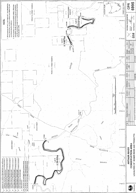
PART 1 - Arthur River Conservation AreaAll that area of land comprising –
bounded by heavy black lines, on Plan 6995 in the Central Plan Register, a reduced copy of which is set out, by way of illustration only, in Part 1 of Schedule 2 to this proclamation.(a) about 25.02 hectares, shown as Lot 1; and(b) about 1.997 hectares, shown as Lot 2; and(c) about 8.571 hectares, shown as Lot 3 –
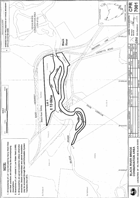
PART 2 - Black River Bridge Conservation AreaAll that area of land comprising about 13.06 hectares, shown as Lot 1 (in 4 parts) and bounded by heavy black lines, on Plan 7001 in the Central Plan Register, a reduced copy of which is set out, by way of illustration only, in Part 2 of Schedule 2 to this proclamation.
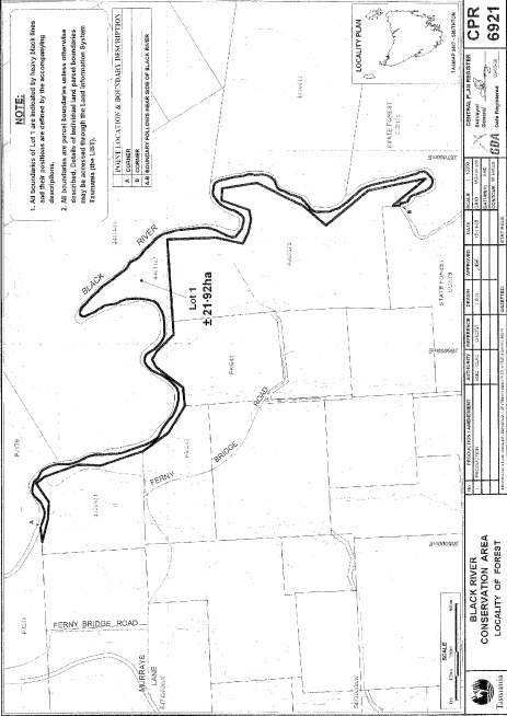
PART 3 - Black River Conservation AreaAll that area of land comprising about 21.92 hectares, shown as Lot 1 and bounded by a heavy black line, on Plan 6921 in the Central Plan Register, a reduced copy of which is set out, by way of illustration only, in Part 3 of Schedule 2 to this proclamation.
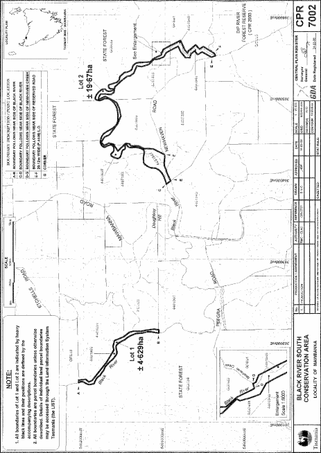
PART 4 - Black River South Conservation AreaAll that area of land comprising –
bounded by heavy black lines, on Plan 7002 in the Central Plan Register, a reduced copy of which is set out, by way of illustration only, in Part 4 of Schedule 2 to this proclamation.(a) about 4.629 hectares, shown as Lot 1; and(b) about 19.67 hectares, shown as Lot 2 –
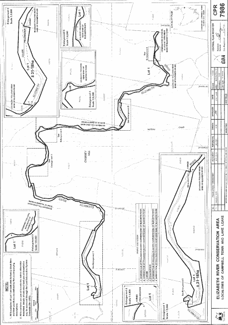
PART 5 - Elizabeth River Conservation AreaAll that area of land comprising about 31.18 hectares, shown as Lot 1 and bounded by a heavy black line, on Plan 7986 in the Central Plan Register, a reduced copy of which is set out, by way of illustration only, in Part 5 of Schedule 2 to this proclamation.
PART 6 - Forth Falls Creek Conservation AreaAll that area of land comprising about 35.15 hectares, shown as Lot 1 and bounded by a heavy black line, on Plan 7578 in the Central Plan Register, a reduced copy of which is set out, by way of illustration only, in Part 6 of Schedule 2 to this proclamation.
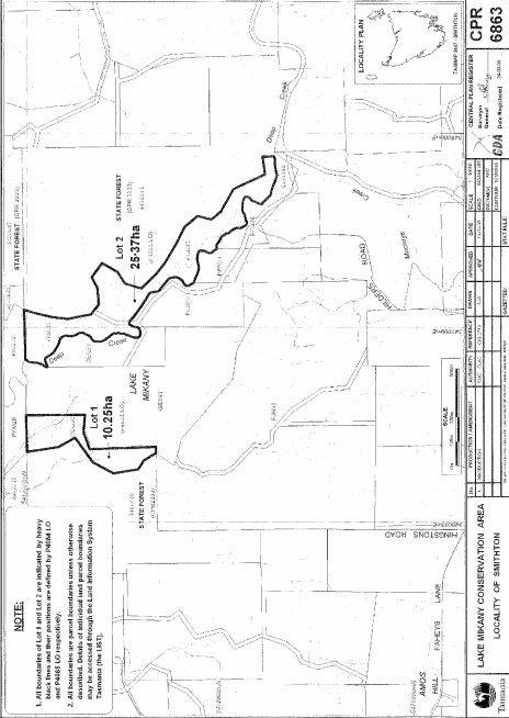
PART 7 - Lake Mikany Conservation AreaAll that area of land comprising –
bounded by heavy black lines, on Plan 6863 in the Central Plan Register, a reduced copy of which is set out, by way of illustration only, in Part 7 of Schedule 2 to this proclamation.(a) about 10.25 hectares, shown as Lot 1; and(b) about 25.37 hectares, shown as Lot 2 –
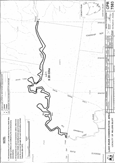
PART 8 - Lake River Conservation AreaAll that area of land comprising about 28.33 hectares, shown as Lot 1 and bounded by a heavy black line, on Plan 7583 in the Central Plan Register, a reduced copy of which is set out, by way of illustration only, in Part 8 of Schedule 2 to this proclamation.
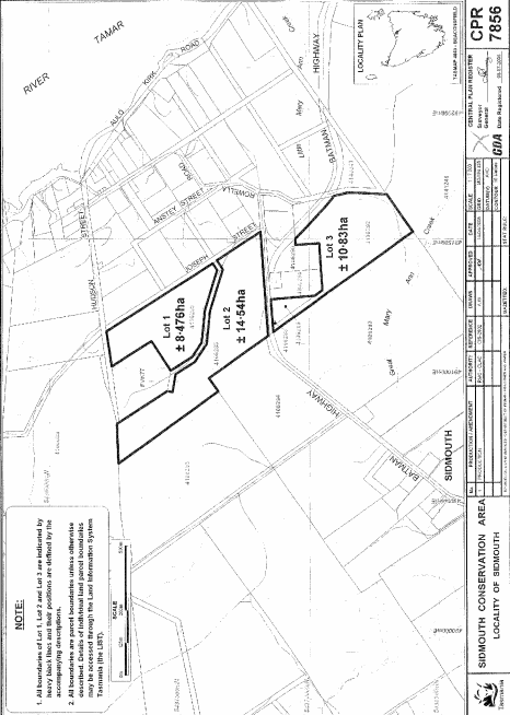
PART 9 - Sidmouth Conservation AreaAll that area of land comprising –
bounded by heavy black lines, on Plan 7856 in the Central Plan Register, a reduced copy of which is set out, by way of illustration only, in Part 9 of Schedule 2 to this proclamation.(a) about 8.476 hectares, shown as Lot 1; and(b) about 14.54 hectares, shown as Lot 2; and(c) about 10.83 hectares, shown as Lot 3 –
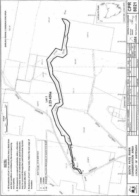
PART 10 - South Pats River Conservation AreaAll that area of land comprising about 23.43 hectares, shown as Lot 1 and bounded by a heavy black line, on Plan 8021 in the Central Plan Register, a reduced copy of which is set out, by way of illustration only, in Part 10 of Schedule 2 to this proclamation.
PART 11 - Wellwood Creek Conservation AreaAll that area of land comprising about 27.8 hectares, shown as Lot 1 and bounded by a heavy black line, on Plan 7520 in the Central Plan Register, a reduced copy of which is set out, by way of illustration only, in Part 11 of Schedule 2 to this proclamation.
SCHEDULE 2 - Plans
PART 1 - Arthur River Conservation Area
PART 2 - Black River Bridge Conservation Area
PART 3 - Black River Conservation Area
PART 4 - Black River South Conservation Area
PART 5 - Elizabeth River Conservation Area
PART 6 - Forth Falls Creek Conservation Area

PART 7 - Lake Mikany Conservation Area
PART 8 - Lake River Conservation Area
PART 9 - Sidmouth Conservation Area
PART 10 - South Pats River Conservation Area
PART 11 - Wellwood Creek Conservation Area

Displayed and numbered in accordance with the Rules Publication Act 1953.
Notified in the Gazette on 16 November 2011
This proclamation is administered in the Department of Primary Industries, Parks, Water and Environment.