

Proclamation under the Nature Conservation Act 2002
I, the Lieutenant-Governor in and over the State of Tasmania and its Dependencies in the Commonwealth of Australia, acting with the advice of the Executive Council, by this my proclamation made under section 11(2) of the Nature Conservation Act 2002 declare –
3 October 2011(a) the Crown land specified in Part 1 of Schedule 1 to this proclamation to be reserved land in the class of conservation area and give the name Craggy Island Conservation Area to that reserved land; and(b) the Crown land specified in Part 2 of Schedule 1 to this proclamation to be reserved land in the class of conservation area and give the name East Cam River Conservation Area to that reserved land; and(c) the Crown land specified in Part 3 of Schedule 1 to this proclamation to be reserved land in the class of conservation area and give the name Holts Point Conservation Area to that reserved land; and(d) the Crown land specified in Part 4 of Schedule 1 to this proclamation to be reserved land in the class of conservation area and give the name Howie Island Conservation Area to that reserved land; and(e) the Crown land specified in Part 5 of Schedule 1 to this proclamation to be reserved land in the class of conservation area and give the name Jacksons Cove Conservation Area to that reserved land; and(f) the Crown land specified in Part 6 of Schedule 1 to this proclamation to be reserved land in the class of conservation area and give the name Jacksons Cove Conservation Area to that reserved land; and(g) the Crown land specified in Part 7 of Schedule 1 to this proclamation to be reserved land in the class of conservation area and give the name Red Reef Conservation Area to that reserved land; and(h) the Crown land specified in Part 8 of Schedule 1 to this proclamation to be reserved land in the class of conservation area and give the name Slaves Bay Conservation Area to that reserved land; and(i) the Crown land specified in Part 9 of Schedule 1 to this proclamation to be reserved land in the class of conservation area and give the name Table Mountain Shore Conservation Area to that reserved land; and(j) the Crown land specified in Part 10 of Schedule 1 to this proclamation to be reserved land in the class of conservation area and give the name Youngs Creek Conservation Area to that reserved land; and(k) that this proclamation takes effect on the day on which its making is notified in the Gazette.
E. C. CRAWFORD
Lieutenant-Governor
By His Excellency's Command,
BRIAN WIGHTMAN
Minister for Environment, Parks and Heritage
SCHEDULE 1 - Areas of Land
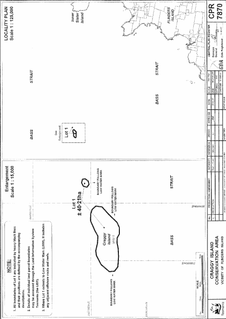
PART 1 - Craggy Island Conservation AreaAll that area of land comprising about 40.21 hectares, shown as Lot 1 (in 2 parts) and bounded by heavy black lines on Plan 7870 in the Central Plan Register, a reduced copy of which is set out, by way of illustration only, in Part 1 of Schedule 2 to this proclamation.
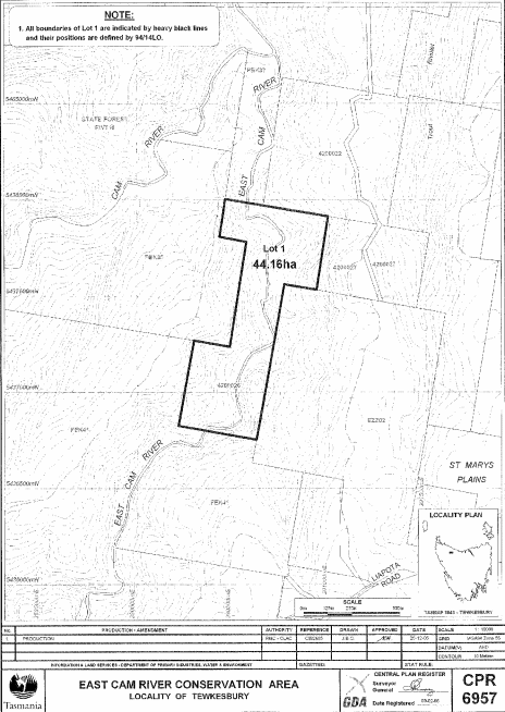
PART 2 - East Cam River Conservation AreaAll that area of land comprising about 44.16 hectares, shown as Lot 1 and bounded by a heavy black line on Plan 6957 in the Central Plan Register, a reduced copy of which is set out, by way of illustration only, in Part 2 of Schedule 2 to this proclamation.
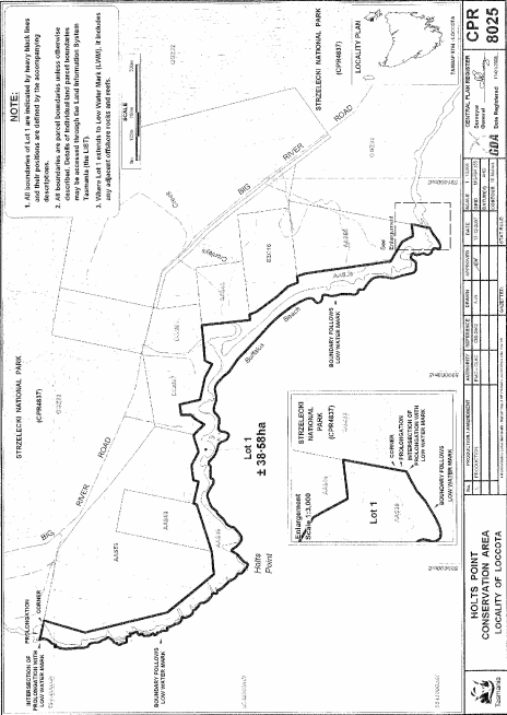
PART 3 - Holts Point Conservation AreaAll that area of land comprising about 38.58 hectares, shown as Lot 1 and bounded by a heavy black line on Plan 8025 in the Central Plan Register, a reduced copy of which is set out, by way of illustration only, in Part 3 of Schedule 2 to this proclamation.
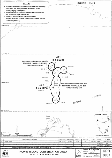
PART 4 - Howie Island Conservation AreaAll that area of land comprising –
bounded by heavy black lines on Plan 8001 in the Central Plan Register, a reduced copy of which is set out, by way of illustration only, in Part 4 of Schedule 2 to this proclamation.(a) about 4.957 hectares, shown as Lot 1; and(b) about 35.59 hectares, shown as Lot 2 –
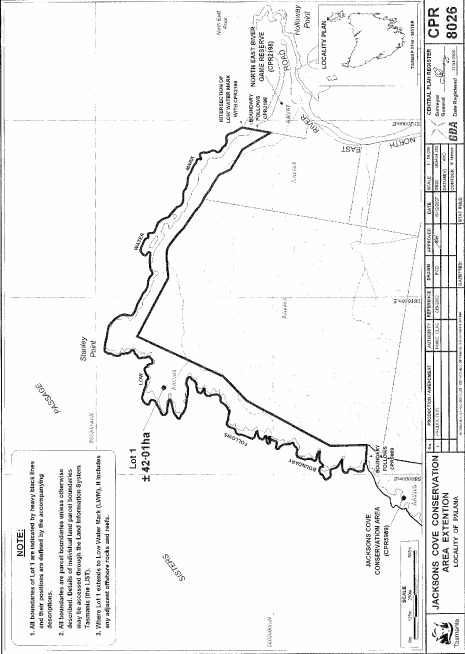
PART 5 - Jacksons Cove Conservation Area (First Extension)All that area of land comprising about 42.01 hectares, shown as Lot 1 and bounded by a heavy black line on Plan 8026 in the Central Plan Register, a reduced copy of which is set out, by way of illustration only, in Part 5 of Schedule 2 to this proclamation.
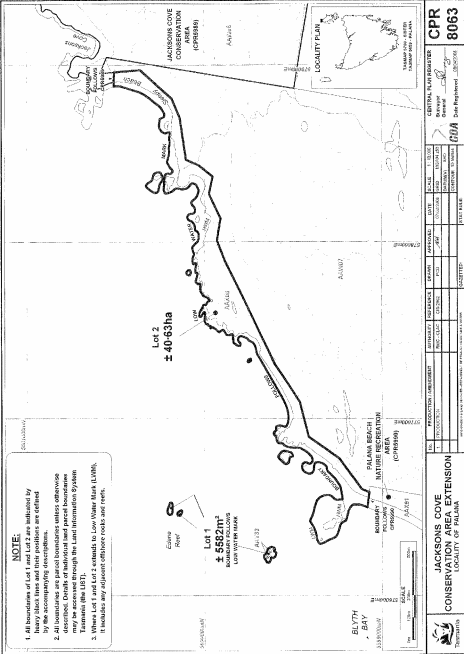
PART 6 - Jacksons Cove Conservation Area (Second Extension)All that area of land comprising –
bounded by heavy black lines on Plan 8063 in the Central Plan Register, a reduced copy of which is set out, by way of illustration only, in Part 6 of Schedule 2 to this proclamation.(a) about 5 582 square metres, shown as Lot 1 (in 3 parts); and(b) about 40.63 hectares, shown as Lot 2 –
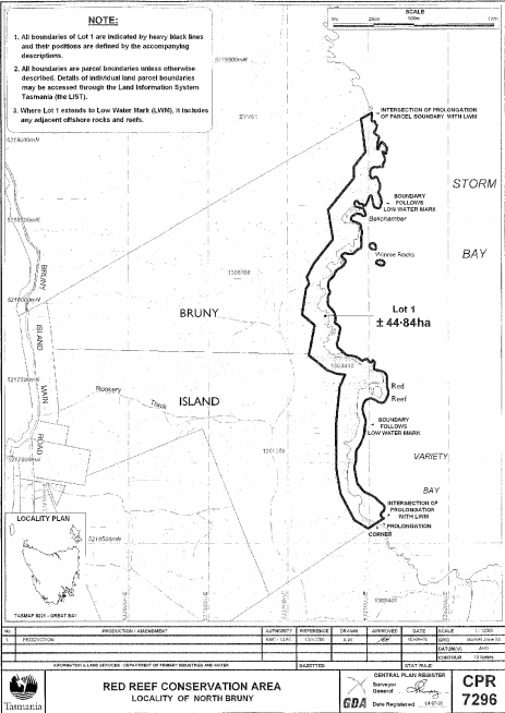
PART 7 - Red Reef Conservation AreaAll that area of land comprising about 44.84 hectares, shown as Lot 1 and bounded by a heavy black line on Plan 7296 in the Central Plan Register, a reduced copy of which is set out, by way of illustration only, in Part 7 of Schedule 2 to this proclamation.
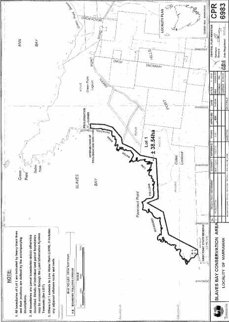
PART 8 - Slaves Bay Conservation AreaAll that area of land comprising about 38.54 hectares, shown as Lot 1 and bounded by a heavy black line on Plan 6983 in the Central Plan Register, a reduced copy of which is set out, by way of illustration only, in Part 8 of Schedule 2 to this proclamation.
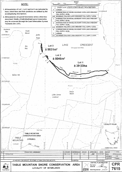
PART 9 - Table Mountain Shore Conservation AreaAll that area of land comprising –
bounded by heavy black lines on Plan 7615 in the Central Plan Register, a reduced copy of which is set out, by way of illustration only, in Part 9 of Schedule 2 to this proclamation.(a) about 39.33 hectares, shown as Lot 1; and(b) about 5 046 square metres, shown as Lot 2; and(c) about 9 831 square metres, shown as Lot 3 –
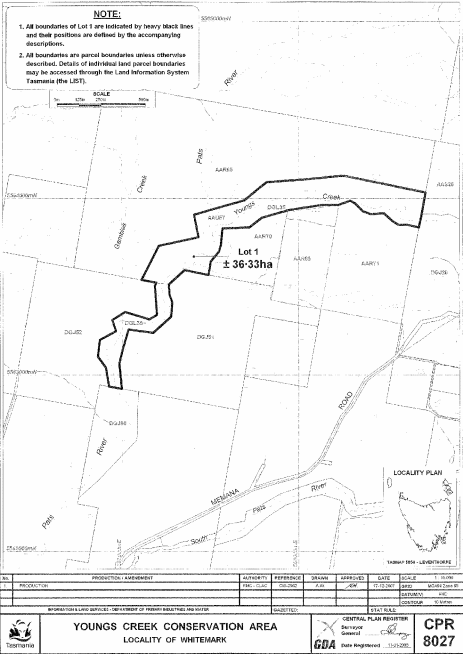
PART 10 - Youngs Creek Conservation AreaAll that area of land comprising about 36.33 hectares, shown as Lot 1 and bounded by a heavy black line on Plan 8027 in the Central Plan Register, a reduced copy of which is set out, by way of illustration only, in Part 10 of Schedule 2 to this proclamation.
SCHEDULE 2 - Plans
PART 1 - Craggy Island Conservation Area
PART 2 - East Cam River Conservation Area
PART 3 - Holts Point Conservation Area
PART 4 - Howie Island Conservation Area
PART 5 - Jacksons Cove Conservation Area (First Extension)
PART 6 - Jacksons Cove Conservation Area (Second Extension)
PART 7 - Red Reef Conservation Area
PART 8 - Slaves Bay Conservation Area
PART 9 - Table Mountain Shore Conservation Area
PART 10 - Youngs Creek Conservation Area
Displayed and numbered in accordance with the Rules Publication Act 1953.
Notified in the Gazette on 12 October 2011
This proclamation is administered in the Department of Primary Industries, Parks, Water and Environment.