

Proclamation under the Nature Conservation Act 2002
I, the Lieutenant-Governor in and over the State of Tasmania and its Dependencies in the Commonwealth of Australia, acting with the advice of the Executive Council, by this my proclamation made under section 11(2) of the Nature Conservation Act 2002 declare –
3 October 2011(a) the Crown land specified in Part 1 of Schedule 1 to this proclamation to be reserved land in the class of conservation area and give the name Calder River Conservation Area to that reserved land; and(b) the Crown land specified in Part 2 of Schedule 1 to this proclamation to be reserved land in the class of conservation area and give the name Chasm Creek Conservation Area to that reserved land; and(c) the Crown land specified in Part 3 of Schedule 1 to this proclamation to be reserved land in the class of conservation area and give the name Crooked Billet Bay Conservation Area to that reserved land; and(d) the Crown land specified in Part 4 of Schedule 1 to this proclamation to be reserved land in the class of conservation area and give the name Edgcumbe Beach Conservation Area to that reserved land; and(e) the Crown land specified in Part 5 of Schedule 1 to this proclamation to be reserved land in the class of conservation area and give the name Good Marsh Conservation Area to that reserved land; and(f) the Crown land specified in Part 6 of Schedule 1 to this proclamation to be reserved land in the class of conservation area and give the name Low Point Conservation Area to that reserved land; and(g) the Crown land specified in Part 7 of Schedule 1 to this proclamation to be reserved land in the class of conservation area and give the name Roydon Island Conservation Area to that reserved land; and(h) the Crown land specified in Part 8 of Schedule 1 to this proclamation to be reserved land in the class of conservation area and give the name Shannon River Conservation Area to that reserved land; and(i) the Crown land specified in Part 9 of Schedule 1 to this proclamation to be reserved land in the class of conservation area and give the name White Beach Conservation Area to that reserved land; and(j) the Crown land specified in Part 10 of Schedule 1 to this proclamation to be reserved land in the class of conservation area and give the name Wyre Forest Creek Conservation Area to that reserved land; and(k) that this proclamation takes effect on the day on which its making is notified in the Gazette.
E. C. CRAWFORD
Lieutenant-Governor
By His Excellency's Command,
BRIAN WIGHTMAN
Minister for Environment, Parks and Heritage
SCHEDULE 1 - Areas of Land
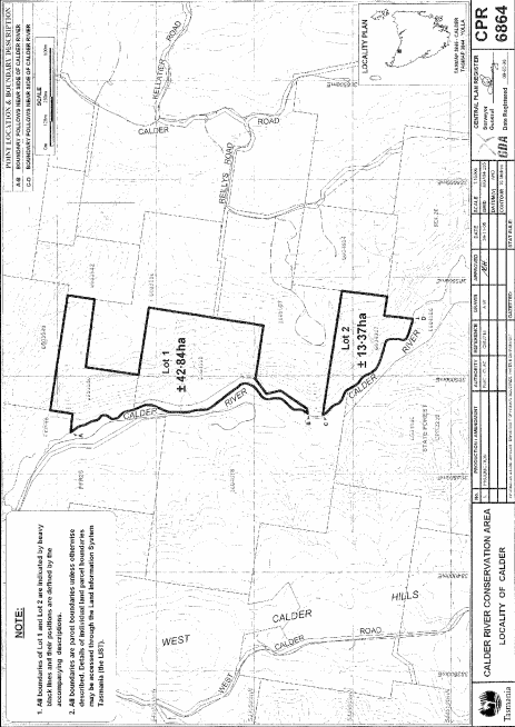
PART 1 - Calder River Conservation AreaAll that area of land comprising –
bounded by heavy black lines on Plan 6864 in the Central Plan Register, a reduced copy of which is set out, by way of illustration only, in Part 1 of Schedule 2 to this proclamation.(a) about 42.84 hectares, shown as Lot 1; and(b) about 13.37 hectares, shown as Lot 2 –
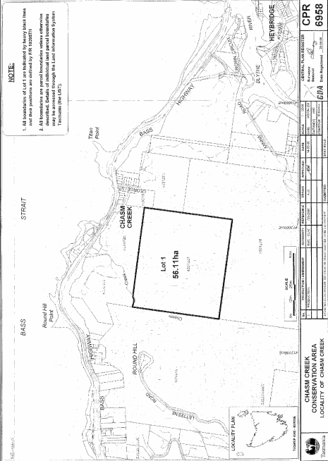
PART 2 - Chasm Creek Conservation AreaAll that area of land comprising about 56.11 hectares, shown as Lot 1 and bounded by a heavy black line on Plan 6958 in the Central Plan Register, a reduced copy of which is set out, by way of illustration only, in Part 2 of Schedule 2 to this proclamation.
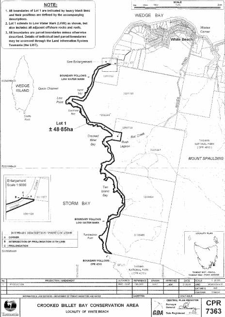
PART 3 - Crooked Billet Bay Conservation AreaAll that area of land comprising about 48.85 hectares, shown as Lot 1 and bounded by a heavy black line on Plan 7363 in the Central Plan Register, a reduced copy of which is set out, by way of illustration only, in Part 3 of Schedule 2 to this proclamation.
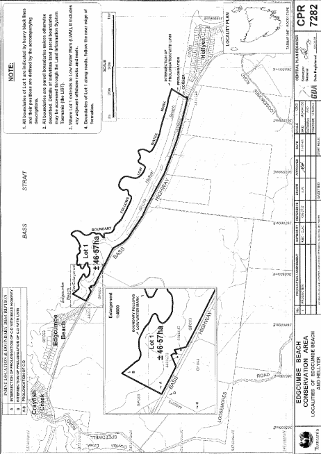
PART 4 - Edgcumbe Beach Conservation AreaAll that area of land comprising about 46.57 hectares, shown as Lot 1 and bounded by a heavy black line on Plan 7282 in the Central Plan Register, a reduced copy of which is set out, by way of illustration only, in Part 4 of Schedule 2 to this proclamation.
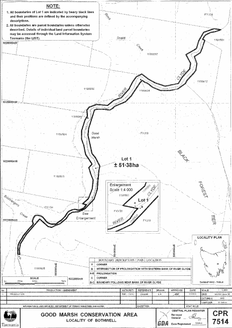
PART 5 - Good Marsh Conservation AreaAll that area of land comprising about 51.38 hectares, shown as Lot 1 and bounded by a heavy black line on Plan 7514 in the Central Plan Register, a reduced copy of which is set out, by way of illustration only, in Part 5 of Schedule 2 to this proclamation.
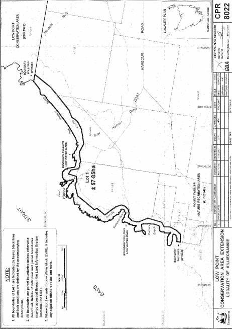
PART 6 - Low Point Conservation AreaAll that area of land comprising about 57.85 hectares, shown as Lot 1 and bounded by a heavy black line on Plan 8022 in the Central Plan Register, a reduced copy of which is set out, by way of illustration only, in Part 6 of Schedule 2 to this proclamation.
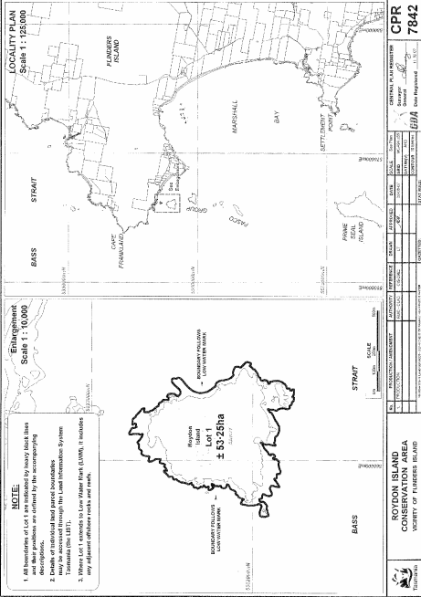
PART 7 - Roydon Island Conservation AreaAll that area of land comprising about 53.25 hectares, shown as Lot 1 and bounded by a heavy black line on Plan 7842 in the Central Plan Register, a reduced copy of which is set out, by way of illustration only, in Part 7 of Schedule 2 to this proclamation.
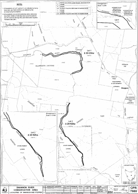
PART 8 - Shannon River Conservation AreaAll that area of land comprising –
bounded by heavy black lines on Plan 7660 in the Central Plan Register, a reduced copy of which is set out, by way of illustration only, in Part 8 of Schedule 2 to this proclamation.(a) about 33.23 hectares, shown as Lot 1; and(b) about 25.92 hectares, shown as Lot 2 –
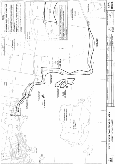
PART 9 - White Beach Conservation AreaAll that area of land comprising –
bounded by heavy black lines on Plan 8024 in the Central Plan Register, a reduced copy of which is set out, by way of illustration only, in Part 9 of Schedule 2 to this proclamation.(a) about 49.51 hectares, shown as Lot 1; and(b) about 9.898 hectares, shown as Lot 2 (in 2 parts); and(c) about 3 076 square metres, shown as Lot 3 –
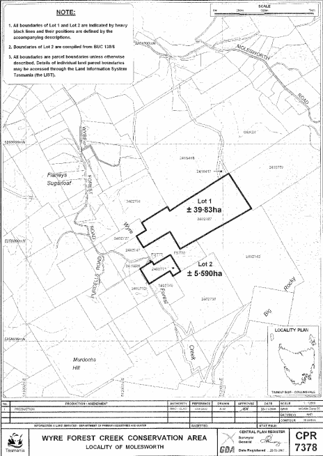
PART 10 - Wyre Forest Creek Conservation AreaAll that area of land comprising –
bounded by heavy black lines on Plan 7378 in the Central Plan Register, a reduced copy of which is set out, by way of illustration only, in Part 10 of Schedule 2 to this proclamation.(a) about 39.83 hectares, shown as Lot 1; and(b) about 5.59 hectares, shown as Lot 2 –
SCHEDULE 2 - Plans
PART 1 - Calder River Conservation Area
PART 2 - Chasm Creek Conservation Area
PART 3 - Crooked Billet Bay Conservation Area
PART 4 - Edgcumbe Beach Conservation Area
PART 5 - Good Marsh Conservation Area
PART 6 - Low Point Conservation Area
PART 7 - Roydon Island Conservation Area
PART 8 - Shannon River Conservation Area
PART 9 - White Beach Conservation Area
PART 10 - Wyre Forest Creek Conservation Area
Displayed and numbered in accordance with the Rules Publication Act 1953.
Notified in the Gazette on 12 October 2011
This proclamation is administered in the Department of Primary Industries, Parks, Water and Environment.