

Proclamation under the Nature Conservation Act 2002
I, the Lieutenant-Governor in and over the State of Tasmania and its Dependencies in the Commonwealth of Australia, acting with the advice of the Executive Council, by this my proclamation made under section 11(2) of the Nature Conservation Act 2002 declare –
19 September 2011(a) the Crown land specified in Part 1 of Schedule 1 to this proclamation to be reserved land in the class of conservation area and give the name Cam River South Conservation Area to that reserved land; and(b) the Crown land specified in Part 2 of Schedule 1 to this proclamation to be reserved land in the class of conservation area and give the name Cleveland Lagoon Conservation Area to that reserved land; and(c) the Crown land specified in Part 3 of Schedule 1 to this proclamation to be reserved land in the class of conservation area and give the name Exe Rivulet Conservation Area to that reserved land; and(d) the Crown land specified in Part 4 of Schedule 1 to this proclamation to be reserved land in the class of conservation area and give the name Fannys Bay Conservation Area to that reserved land; and(e) the Crown land specified in Part 5 of Schedule 1 to this proclamation to be reserved land in the class of conservation area and give the name Middle Island Conservation Area to that reserved land; and(f) the Crown land specified in Part 6 of Schedule 1 to this proclamation to be reserved land in the class of conservation area and give the name North West Bay Conservation Area to that reserved land; and(g) the Crown land specified in Part 7 of Schedule 1 to this proclamation to be reserved land in the class of conservation area and give the name Pardoe Northdown Conservation Area to that reserved land; and(h) the Crown land specified in Part 8 of Schedule 1 to this proclamation to be reserved land in the class of conservation area and give the name Plenty River Conservation Area to that reserved land; and(i) the Crown land specified in Part 9 of Schedule 1 to this proclamation to be reserved land in the class of conservation area and give the name St Helens Conservation Area to that reserved land; and(j) the Crown land specified in Part 10 of Schedule 1 to this proclamation to be reserved land in the class of conservation area and give the name Wallaby Islands Conservation Area to that reserved land; and(k) that this proclamation takes effect on the day on which its making is notified in the Gazette.
E. C. CRAWFORD
Lieutenant-Governor
By His Excellency's Command,
BRIAN WIGHTMAN
Minister for Environment, Parks and Heritage
SCHEDULE 1 - Areas of Land
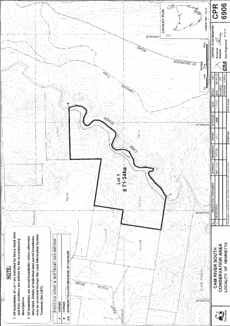
PART 1 - Cam River South Conservation AreaAll that area of land comprising about 71.34 hectares, shown as Lot 1 and bounded by a heavy black line on Plan 6906 in the Central Plan Register, a reduced copy of which is set out, by way of illustration only, in Part 1 of Schedule 2 to this proclamation.
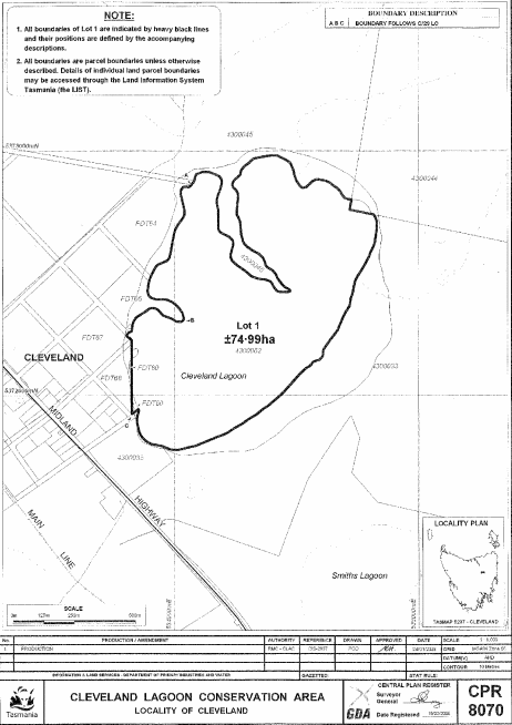
PART 2 - Cleveland Lagoon Conservation AreaAll that area of land comprising about 74.99 hectares, shown as Lot 1 and bounded by a heavy black line on Plan 8070 in the Central Plan Register, a reduced copy of which is set out, by way of illustration only, in Part 2 of Schedule 2 to this proclamation.
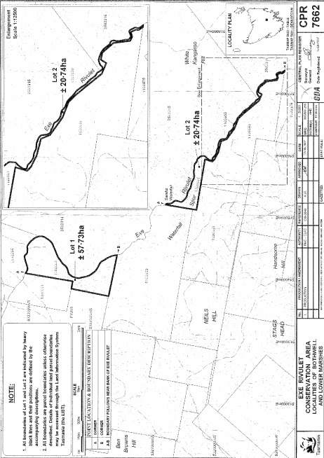
PART 3 - Exe Rivulet Conservation AreaAll that area of land comprising –
bounded by heavy black lines on Plan 7662 in the Central Plan Register, a reduced copy of which is set out, by way of illustration only, in Part 3 of Schedule 2 to this proclamation.(a) about 57.73 hectares, shown as Lot 1; and(b) about 20.74 hectares, shown as Lot 2 –
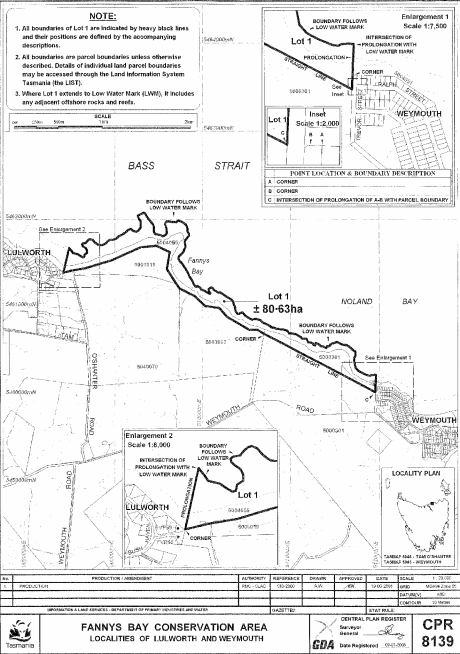
PART 4 - Fannys Bay Conservation AreaAll that area of land comprising about 80.63 hectares, shown as Lot 1 and bounded by a heavy black line on Plan 8139 in the Central Plan Register, a reduced copy of which is set out, by way of illustration only, in Part 4 of Schedule 2 to this proclamation.
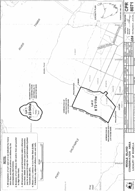
PART 5 - Middle Island Conservation AreaAll that area of land comprising –
bounded by heavy black lines on Plan 8071 in the Central Plan Register, a reduced copy of which is set out, by way of illustration only, in Part 5 of Schedule 2 to this proclamation.(a) about 23.54 hectares, shown as Lot 1; and(b) about 72.11 hectares, shown as Lot 2 –
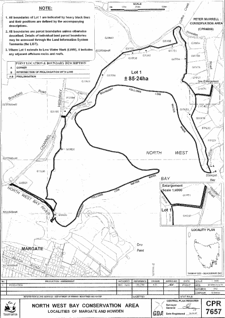
PART 6 - North West Bay Conservation AreaAll that area of land comprising about 85.24 hectares, shown as Lot 1 and bounded by a heavy black line on Plan 7657 in the Central Plan Register, a reduced copy of which is set out, by way of illustration only, in Part 6 of Schedule 2 to this proclamation.
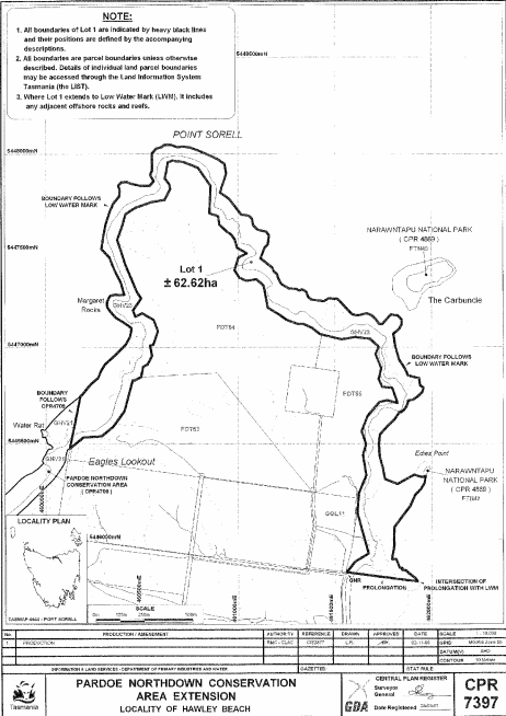
PART 7 - Pardoe Northdown Conservation AreaAll that area of land comprising about 62.62 hectares, shown as Lot 1 and bounded by a heavy black line on Plan 7397 in the Central Plan Register, a reduced copy of which is set out, by way of illustration only, in Part 7 of Schedule 2 to this proclamation.
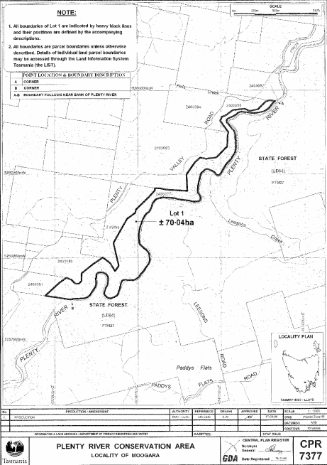
PART 8 - Plenty River Conservation AreaAll that area of land comprising about 70.04 hectares, shown as Lot 1 and bounded by a heavy black line on Plan 7377 in the Central Plan Register, a reduced copy of which is set out, by way of illustration only, in Part 8 of Schedule 2 to this proclamation.
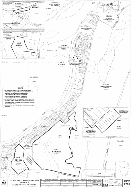
PART 9 - St Helens Conservation AreaAll that area of land comprising –
bounded by heavy black lines on Plan 7775 in the Central Plan Register, a reduced copy of which is set out, by way of illustration only, in Part 9 of Schedule 2 to this proclamation.(a) about 1 765 square metres, shown as Lot 1; and(b) about 8 149 square metres, shown as Lot 2; and(c) about 59.26 hectares, shown as Lot 3; and(d) about 10.13 hectares, shown as Lot 4 –
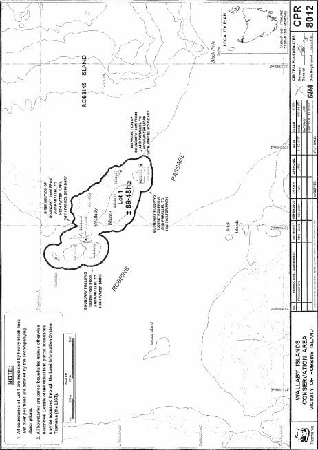
PART 10 - Wallaby Islands Conservation AreaAll that area of land comprising about 89.48 hectares, shown as Lot 1 and bounded by a heavy black line on Plan 8012 in the Central Plan Register, a reduced copy of which is set out, by way of illustration only, in Part 10 of Schedule 2 to this proclamation.
SCHEDULE 2 - Plans
PART 1 - Cam River South Conservation Area
PART 2 - Cleveland Lagoon Conservation Area
PART 3 - Exe Rivulet Conservation Area
PART 4 - Fannys Bay Conservation Area
PART 5 - Middle Island Conservation Area
PART 6 - North West Bay Conservation Area
PART 7 - Pardoe Northdown Conservation Area
PART 8 - Plenty River Conservation Area
PART 9 - St Helens Conservation Area
PART 10 - Wallaby Islands Conservation Area
Displayed and numbered in accordance with the Rules Publication Act 1953.
Notified in the Gazette on 28 September 2011
This proclamation is administered in the Department of Primary Industries, Parks, Water and Environment.