

Proclamation under the Nature Conservation Act 2002
I, the Governor in and over the State of Tasmania and its Dependencies in the Commonwealth of Australia, acting with the advice of the Executive Council, by this my proclamation made under section 11(2) of the Nature Conservation Act 2002 declare –
26 July 2011(a) the Crown land specified in Part 1 of Schedule 1 to this proclamation to be reserved land in the class of nature recreation area and give the name Briant Hill Nature Recreation Area to that reserved land; and(b) the Crown land specified in Part 2 of Schedule 1 to this proclamation to be reserved land in the class of nature recreation area and give the name Emita Nature Recreation Area to that reserved land; and(c) the Crown land specified in Part 3 of Schedule 1 to this proclamation to be reserved land in the class of nature recreation area and give the name Gellibrand Point Nature Recreation Area to that reserved land; and(d) the Crown land specified in Part 4 of Schedule 1 to this proclamation to be reserved land in the class of nature recreation area and give the name Gordons Hill Nature Recreation Area to that reserved land; and(e) the Crown land specified in Part 5 of Schedule 1 to this proclamation to be reserved land in the class of nature recreation area and give the name Humbug Point Nature Recreation Area to that reserved land; and(f) the Crown land specified in Part 6 of Schedule 1 to this proclamation to be reserved land in the class of nature recreation area and give the name Killiecrankie Nature Recreation Area to that reserved land; and(g) the Crown land specified in Part 7 of Schedule 1 to this proclamation to be reserved land in the class of nature recreation area and give the name Knopwood Hill Nature Recreation Area to that reserved land; and(h) the Crown land specified in Part 8 of Schedule 1 to this proclamation to be reserved land in the class of nature recreation area and give the name Meehan Range Nature Recreation Area to that reserved land; and(i) the Crown land specified in Part 9 of Schedule 1 to this proclamation to be reserved land in the class of nature recreation area and give the name Meehan Range Nature Recreation Area to that reserved land; and(j) the Crown land specified in Part 10 of Schedule 1 to this proclamation to be reserved land in the class of nature recreation area and give the name Meehan Range Nature Recreation Area to that reserved land; and(k) the Crown land specified in Part 11 of Schedule 1 to this proclamation to be reserved land in the class of nature recreation area and give the name Pirates Bay Nature Recreation Area to that reserved land; and(l) the Crown land specified in Part 12 of Schedule 1 to this proclamation to be reserved land in the class of nature recreation area and give the name Reynolds Falls Nature Recreation Area to that reserved land; and(m) that this proclamation takes effect on the day on which its making is notified in the Gazette.
PETER G. UNDERWOOD
Governor
By His Excellency's Command,
BRIAN WIGHTMAN
Minister for Environment, Parks and Heritage
SCHEDULE 1 - Areas of land
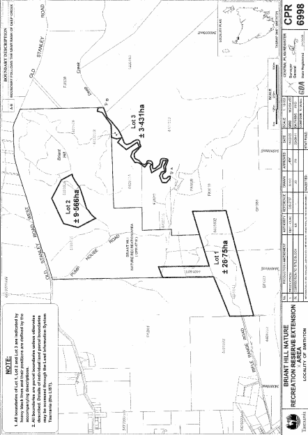
PART 1 - Briant Hill Nature Recreation AreaAll that area of land comprising –
bounded by heavy black lines on Plan 6998 in the Central Plan Register, a reduced copy of which is set out, by way of illustration only, in Part 1 of Schedule 2 to this proclamation.(a) about 26.75 hectares, shown as Lot 1; and(b) about 9.566 hectares, shown as Lot 2; and(c) about 3.431 hectares, shown as Lot 3 –
PART 2 - Emita Nature Recreation AreaAll that area of land comprising about 4.652 hectares, shown as Lot 1 and bounded by a heavy black line on Plan 8029 in the Central Plan Register, a reduced copy of which is set out, by way of illustration only, in Part 2 of Schedule 2 to this proclamation.
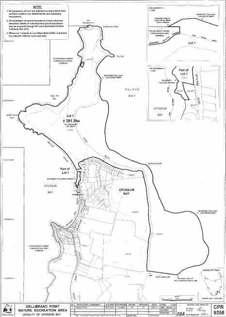
PART 3 - Gellibrand Point Nature Recreation AreaAll that area of land comprising about 281.2 hectares, shown as Lot 1 in two parts and bounded by heavy black lines on Plan 9258 in the Central Plan Register, a reduced copy of which is set out, by way of illustration only, in Part 3 of Schedule 2 to this proclamation.
PART 4 - Gordons Hill Nature Recreation AreaAll that area of land comprising about 3.039 hectares, shown as Lot 1 and bounded by a heavy black line on Plan 7883 in the Central Plan Register, a reduced copy of which is set out, by way of illustration only, in Part 4 of Schedule 2 to this proclamation.
PART 5 - Humbug Point Nature Recreation AreaAll that area of land comprising about 35.26 hectares, shown as Lot 1 in two parts and bounded by heavy black lines on Plan 7717 in the Central Plan Register, a reduced copy of which is set out, by way of illustration only, in Part 5 of Schedule 2 to this proclamation.
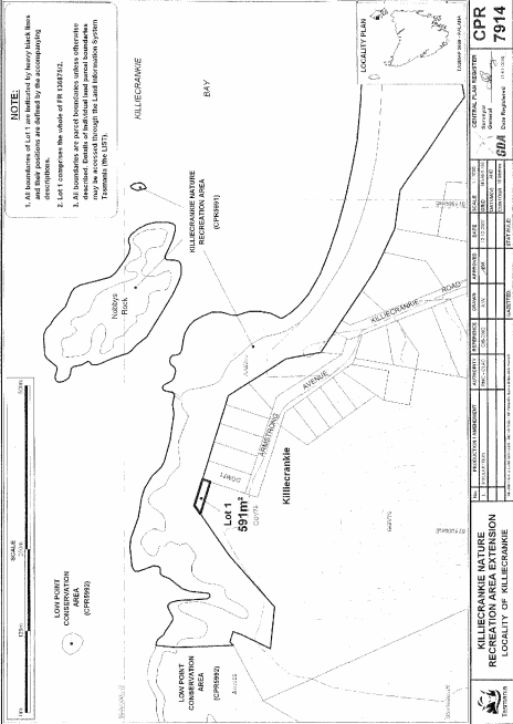
PART 6 - Killiecrankie Nature Recreation AreaAll that area of land comprising about 591 square metres, shown as Lot 1 and bounded by a heavy black line on Plan 7914 in the Central Plan Register, a reduced copy of which is set out, by way of illustration only, in Part 6 of Schedule 2 to this proclamation.
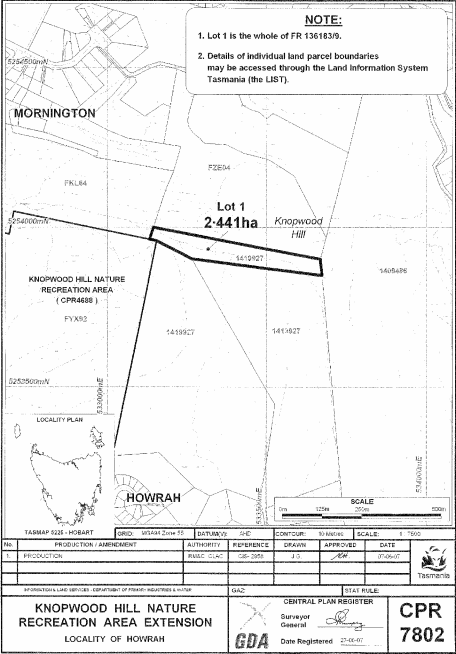
PART 7 - Knopwood Hill Nature Recreation AreaAll that area of land comprising about 2.441 hectares, shown as Lot 1 and bounded by a heavy black line on Plan 7802 in the Central Plan Register, a reduced copy of which is set out, by way of illustration only, in Part 7 of Schedule 2 to this proclamation.
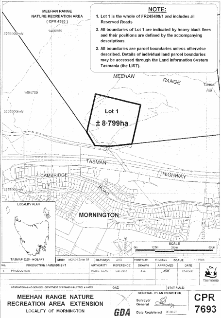
PART 8 - Meehan Range Nature Recreation Area (First Extension)All that area of land comprising about 8.799 hectares, shown as Lot 1 and bounded by a heavy black line on Plan 7693 in the Central Plan Register, a reduced copy of which is set out, by way of illustration only, in Part 8 of Schedule 2 to this proclamation.
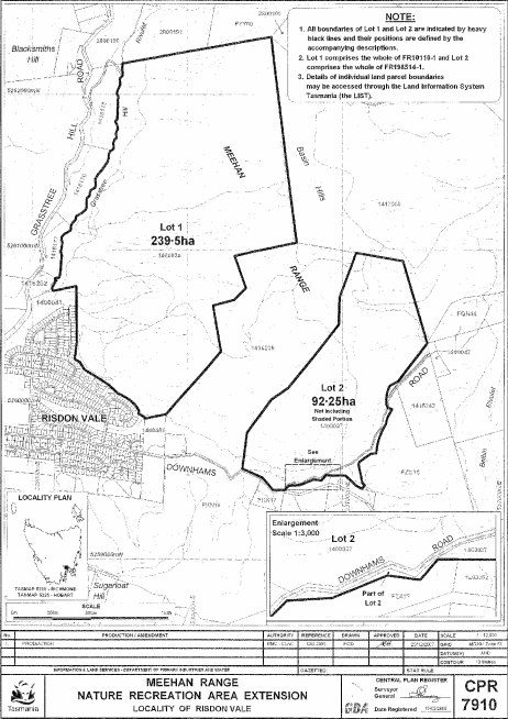
PART 9 - Meehan Range Nature Recreation Area (Second Extension)All that area of land comprising –
bounded by heavy black lines on Plan 7910 in the Central Plan Register, a reduced copy of which is set out, by way of illustration only, in Part 9 of Schedule 2 to this proclamation.(a) about 239.5 hectares, shown as Lot 1; and(b) about 92.25 hectares, shown as Lot 2 –
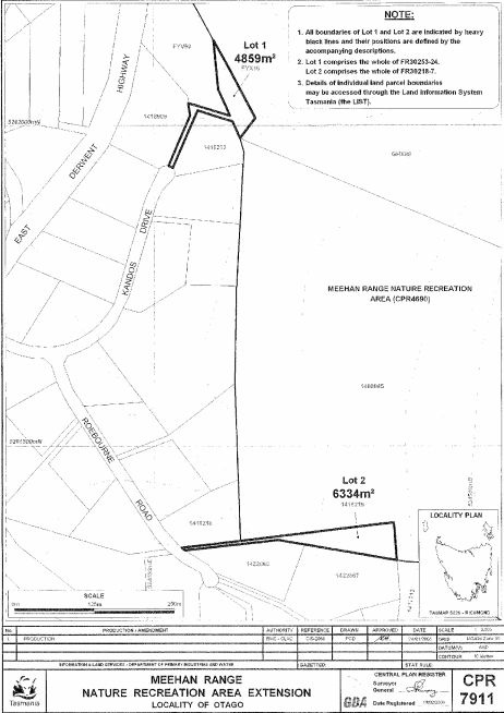
PART 10 - Meehan Range Nature Recreation Area (Third Extension)All that area of land comprising –
bounded by heavy black lines on Plan 7911 in the Central Plan Register, a reduced copy of which is set out, by way of illustration only, in Part 10 of Schedule 2 to this proclamation.(a) about 4 859 square metres, shown as Lot 1; and(b) about 6 334 square metres, shown as Lot 2 –
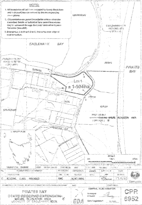
PART 11 - Pirates Bay Nature Recreation AreaAll that area of land comprising about 1.504 hectares, shown as Lot 1 and bounded by a heavy black line on Plan 6952 in the Central Plan Register, a reduced copy of which is set out, by way of illustration only, in Part 11 of Schedule 2 to this proclamation.
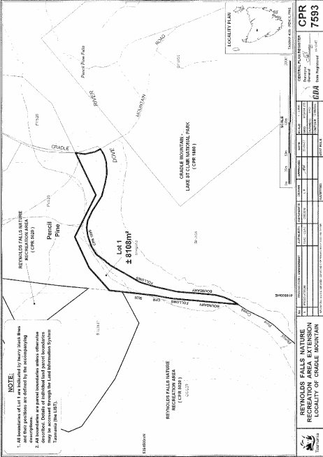
PART 12 - Reynolds Falls Nature Recreation AreaAll that area of land comprising about 8 108 square metres, shown as Lot 1 and bounded by a heavy black line on Plan 7593 in the Central Plan Register, a reduced copy of which is set out, by way of illustration only, in Part 12 of Schedule 2 to this proclamation.
SCHEDULE 2 - Plans
PART 1 - Briant Hill Nature Recreation Area
PART 2 - Emita Nature Recreation Area

PART 3 - Gellibrand Point Nature Recreation Area
PART 4 - Gordons Hill Nature Recreation Area

PART 5 - Humbug Point Nature Recreation Area

PART 6 - Killiecrankie Nature Recreation Area
PART 7 - Knopwood Hill Nature Recreation Area
PART 8 - Meehan Range Nature Recreation Area (First Extension)
PART 9 - Meehan Range Nature Recreation Area (Second Extension)
PART 10 - Meehan Range Nature Recreation Area (Third Extension)
PART 11 - Pirates Bay Nature Recreation Area
PART 12 - Reynolds Falls Nature Recreation Area
Displayed and numbered in accordance with the Rules Publication Act 1953.
Notified in the Gazette on 3 August 2011
This proclamation is administered in the Department of Primary Industries, Parks, Water and Environment.