

Proclamation under the Nature Conservation Act 2002
I, the Governor in and over the State of Tasmania and its Dependencies in the Commonwealth of Australia, acting with the advice of the Executive Council, by this my proclamation made under section 11(2) of the Nature Conservation Act 2002 declare –
26 July 2011(a) the Crown land specified in Part 1 of Schedule 1 to this proclamation to be reserved land in the class of conservation area and give the name Arthur-Pieman Conservation Area to that reserved land; and(b) the Crown land specified in Part 2 of Schedule 1 to this proclamation to be reserved land in the class of conservation area and give the name Brougham Sugarloaf Conservation Area to that reserved land; and(c) the Crown land specified in Part 3 of Schedule 1 to this proclamation to be reserved land in the class of conservation area and give the name Cataraqui Point Conservation Area to that reserved land; and(d) the Crown land specified in Part 4 of Schedule 1 to this proclamation to be reserved land in the class of conservation area and give the name Emu River Conservation Area to that reserved land; and(e) the Crown land specified in Part 5 of Schedule 1 to this proclamation to be reserved land in the class of conservation area and give the name Little Pine Lagoon Conservation Area to that reserved land; and(f) the Crown land specified in Part 6 of Schedule 1 to this proclamation to be reserved land in the class of conservation area and give the name Little Swanport Conservation Area to that reserved land; and(g) the Crown land specified in Part 7 of Schedule 1 to this proclamation to be reserved land in the class of conservation area and give the name Long Island Conservation Area to that reserved land; and(h) the Crown land specified in Part 8 of Schedule 1 to this proclamation to be reserved land in the class of conservation area and give the name Passage Island Conservation Area to that reserved land; and(i) the Crown land specified in Part 9 of Schedule 1 to this proclamation to be reserved land in the class of conservation area and give the name Seal Rocks Conservation Area to that reserved land; and(j) the Crown land specified in Part 10 of Schedule 1 to this proclamation to be reserved land in the class of conservation area and give the name Stokes Point Conservation Area to that reserved land; and(k) that this proclamation takes effect on the day on which its making is notified in the Gazette.
PETER G. UNDERWOOD
Governor
By His Excellency's Command,
BRIAN WIGHTMAN
Minister for Environment, Parks and Heritage
SCHEDULE 1 - Areas of land
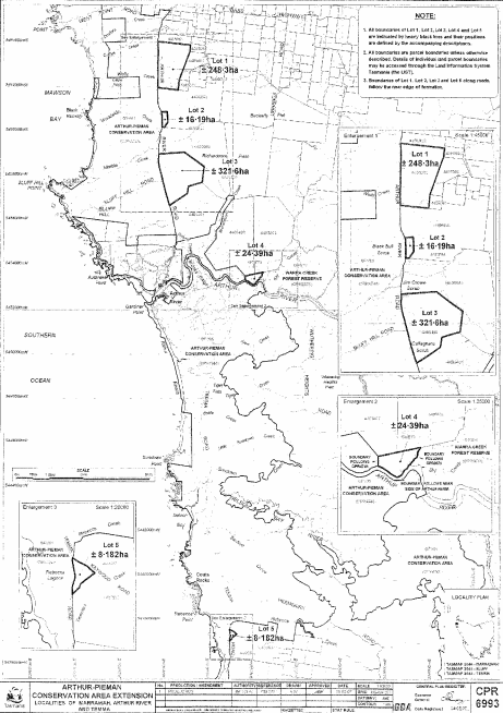
PART 1 - Arthur-Pieman Conservation AreaAll that area of land comprising –
bounded by heavy black lines on Plan 6993 in the Central Plan Register, a reduced copy of which is set out, by way of illustration only, in Part 1 of Schedule 2 to this proclamation.(a) about 248.3 hectares, shown as Lot 1; and(b) about 16.19 hectares, shown as Lot 2; and(c) about 321.6 hectares, shown as Lot 3; and(d) about 24.39 hectares, shown as Lot 4; and(e) about 8.182 hectares, shown as Lot 5 –
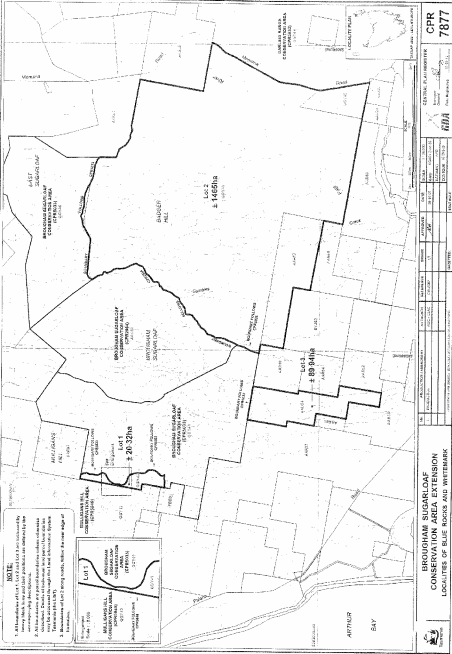
PART 2 - Brougham Sugarloaf Conservation AreaAll that area of land comprising –
bounded by heavy black lines on Plan 7877 in the Central Plan Register, a reduced copy of which is set out, by way of illustration only, in Part 2 of Schedule 2 to this proclamation.(a) about 20.32 hectares, shown as Lot 1; and(b) about 1 465 hectares, shown as Lot 2; and(c) about 89.94 hectares, shown as Lot 3 –
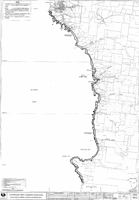
PART 3 - Cataraqui Point Conservation AreaAll that area of land comprising about 301.1 hectares, shown as Lot 1 and bounded by a heavy black line on Plan 6932 in the Central Plan Register, a reduced copy of which is set out, by way of illustration only, in Part 3 of Schedule 2 to this proclamation.
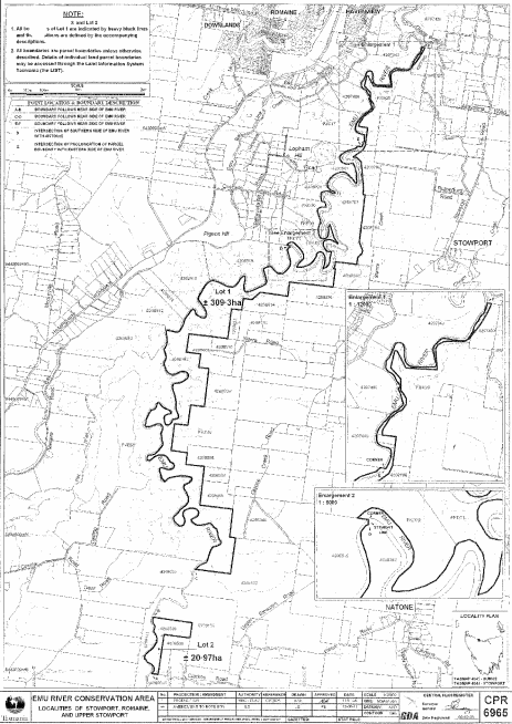
PART 4 - Emu River Conservation AreaAll that area of land comprising –
bounded by heavy black lines on Plan 6965 in the Central Plan Register, a reduced copy of which is set out, by way of illustration only, in Part 4 of Schedule 2 to this proclamation.(a) about 309.3 hectares, shown as Lot 1; and(b) about 20.97 hectares, shown as Lot 2 –
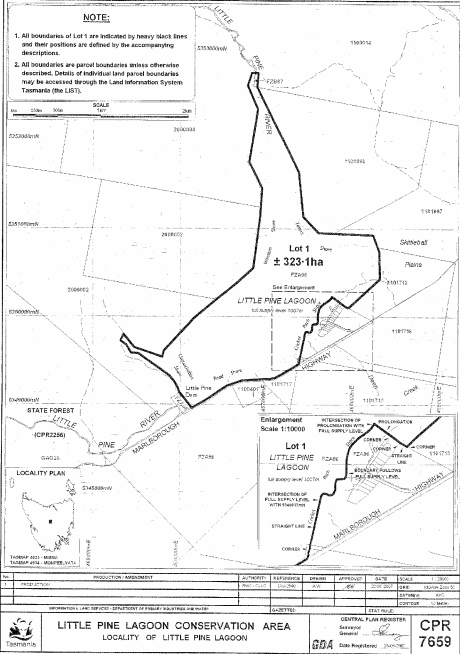
PART 5 - Little Pine Lagoon Conservation AreaAll that area of land comprising about 323.1 hectares, shown as Lot 1 and bounded by a heavy black line on Plan 7659 in the Central Plan Register, a reduced copy of which is set out, by way of illustration only, in Part 5 of Schedule 2 to this proclamation.
PART 6 - Little Swanport Conservation AreaAll that area of land comprising –
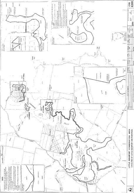
bounded by heavy black lines on Plan 8205 in the Central Plan Register, a reduced copy of which is set out, by way of illustration only, in Part 6 of Schedule 2 to this proclamation.(a) about 17.76 hectares, shown as Lot 1; and(b) about 5.895 hectares, shown as Lot 2; and(c) about 3.043 hectares, shown as Lot 3; and(d) about 377.2 hectares, shown as Lot 4 –
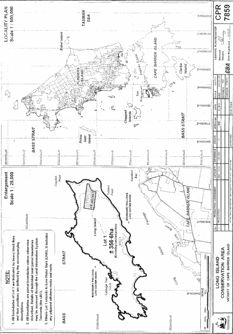
PART 7 - Long Island Conservation AreaAll that area of land (excluding the hatched portion) comprising about 356.6 hectares, shown as Lot 1 and bounded by heavy black lines on Plan 7859 in the Central Plan Register, a reduced copy of which is set out, by way of illustration only, in Part 7 of Schedule 2 to this proclamation.
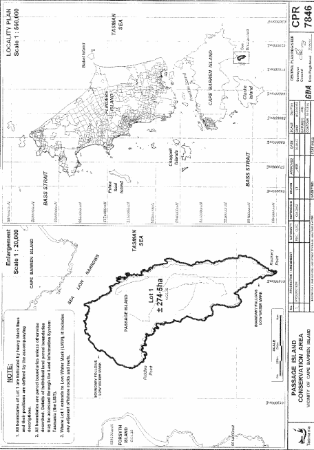
PART 8 - Passage Island Conservation AreaAll that area of land comprising about 274.5 hectares, shown as Lot 1 and bounded by a heavy black line on Plan 7846 in the Central Plan Register, a reduced copy of which is set out, by way of illustration only, in Part 8 of Schedule 2 to this proclamation.
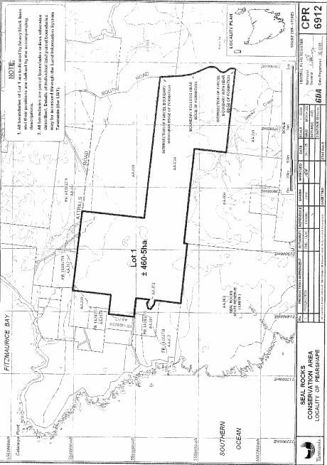
PART 9 - Seal Rocks Conservation AreaAll that area of land comprising about 460.5 hectares, shown as Lot 1 and bounded by a heavy black line on Plan 6912 in the Central Plan Register, a reduced copy of which is set out, by way of illustration only, in Part 9 of Schedule 2 to this proclamation.
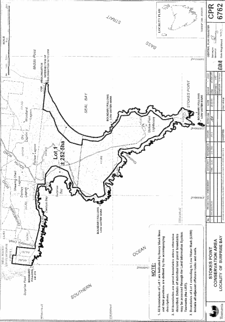
PART 10 - Stokes Point Conservation AreaAll that area of land comprising about 252.5 hectares, shown as Lot 1 and bounded by heavy black lines on Plan 6762 in the Central Plan Register, a reduced copy of which is set out, by way of illustration only, in Part 10 of Schedule 2 to this proclamation.
SCHEDULE 2 - Plans
PART 1 - Arthur-Pieman Conservation Area
PART 2 - Brougham Sugarloaf Conservation Area
PART 3 - Cataraqui Point Conservation Area
PART 4 - Emu River Conservation Area
PART 5 - Little Pine Lagoon Conservation Area
PART 6 - Little Swanport Conservation Area
PART 7 - Long Island Conservation Area
PART 8 - Passage Island Conservation Area
PART 9 - Seal Rocks Conservation Area
PART 10 - Stokes Point Conservation Area
Displayed and numbered in accordance with the Rules Publication Act 1953.
Notified in the Gazette on 3 August 2011
This proclamation is administered in the Department of Primary Industries, Parks, Water and Environment.