

Proclamation under the Nature Conservation Act 2002
I, the Governor in and over the State of Tasmania and its Dependencies in the Commonwealth of Australia, acting with the advice of the Executive Council, by this my proclamation made under section 11(2) of the Nature Conservation Act 2002 declare –
4 July 2011(a) the Crown land specified in Part 1 of Schedule 1 to this proclamation to be reserved land in the class of regional reserve and give the name Crotty Ridge Regional Reserve to that reserved land; and(b) the Crown land specified in Part 2 of Schedule 1 to this proclamation to be reserved land in the class of regional reserve and give the name Mount Farrell Regional Reserve to that reserved land; and(c) the Crown land specified in Part 3 of Schedule 1 to this proclamation to be reserved land in the class of regional reserve and give the name Mount Heemskirk Regional Reserve to that reserved land; and(d) the Crown land specified in Part 4 of Schedule 1 to this proclamation to be reserved land in the class of regional reserve and give the name Mount Heemskirk Regional Reserve to that reserved land; and(e) the Crown land specified in Part 5 of Schedule 1 to this proclamation to be reserved land in the class of regional reserve and give the name Mount Heemskirk Regional Reserve to that reserved land; and(f) the Crown land specified in Part 6 of Schedule 1 to this proclamation to be reserved land in the class of regional reserve and give the name Mount Roland Regional Reserve to that reserved land; and(g) the Crown land specified in Part 7 of Schedule 1 to this proclamation to be reserved land in the class of regional reserve and give the name Renison Bell Regional Reserve to that reserved land; and(h) the Crown land specified in Part 8 of Schedule 1 to this proclamation to be reserved land in the class of regional reserve and give the name Savage River Regional Reserve to that reserved land; and(i) that this proclamation takes effect on the day on which its making is notified in the Gazette.
PETER G. UNDERWOOD
Governor
By His Excellency's Command,
BRIAN WIGHTMAN
Minister for Environment, Parks and Heritage
SCHEDULE 1 - Areas of land
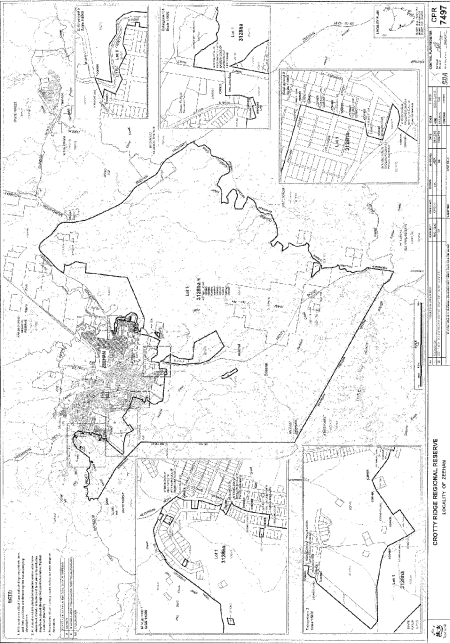
PART 1 - Crotty Ridge Regional ReserveAll that area of land comprising about 3 128 hectares, shown as Lot 1 and bounded by a heavy black line on Plan 7497 in the Central Plan Register, a reduced copy of which is set out, by way of illustration only, in Part 1 of Schedule 2 to this proclamation.
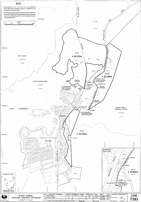
PART 2 - Mount Farrell Regional ReserveAll that area of land comprising –
bounded by heavy black lines on Plan 7293 in the Central Plan Register, a reduced copy of which is set out, by way of illustration only, in Part 2 of Schedule 2 to this proclamation.(a) about 46.93 hectares, shown as Lot 1; and(b) about 22.35 hectares, shown as Lot 2; and(c) about 10.83 hectares, shown as Lot 3 –
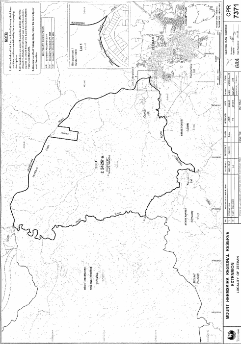
PART 3 - Mount Heemskirk Regional Reserve (First extension)All that area of land comprising about 2 425 hectares, shown as Lot 1 and bounded by a heavy black line on Plan 7371 in the Central Plan Register, a reduced copy of which is set out, by way of illustration only, in Part 3 of Schedule 2 to this proclamation.
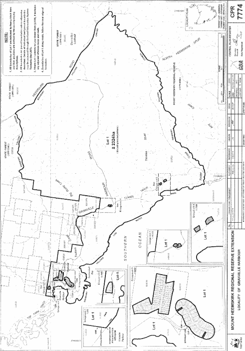
PART 4 - Mount Heemskirk Regional Reserve (Second extension)All that area of land comprising about 2 324 hectares, shown as Lot 1 and bounded by a heavy black line on Plan 7774 in the Central Plan Register, a reduced copy of which is set out, by way of illustration only, in Part 4 of Schedule 2 to this proclamation.
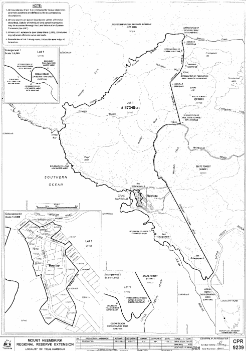
PART 5 - Mount Heemskirk Regional Reserve (Third extension)All that area of land comprising about 873.6 hectares, shown as Lot 1 and bounded by a heavy black line on Plan 9239 in the Central Plan Register, a reduced copy of which is set out, by way of illustration only, in Part 5 of Schedule 2 to this proclamation.
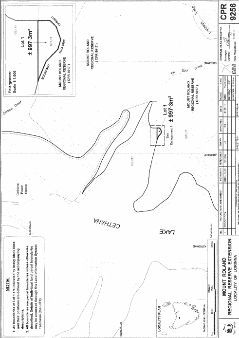
PART 6 - Mount Roland Regional ReserveAll that area of land comprising about 997.3 square metres, shown as Lot 1 and bounded by a heavy black line on Plan 9256 in the Central Plan Register, a reduced copy of which is set out, by way of illustration only, in Part 6 of Schedule 2 to this proclamation.
PART 7 - Renison Bell Regional ReserveAll that area of land comprising about 753.8 hectares, shown as Lot 1 and bounded by a heavy black line on Plan 7318 in the Central Plan Register, a reduced copy of which is set out, by way of illustration only, in Part 7 of Schedule 2 to this proclamation.
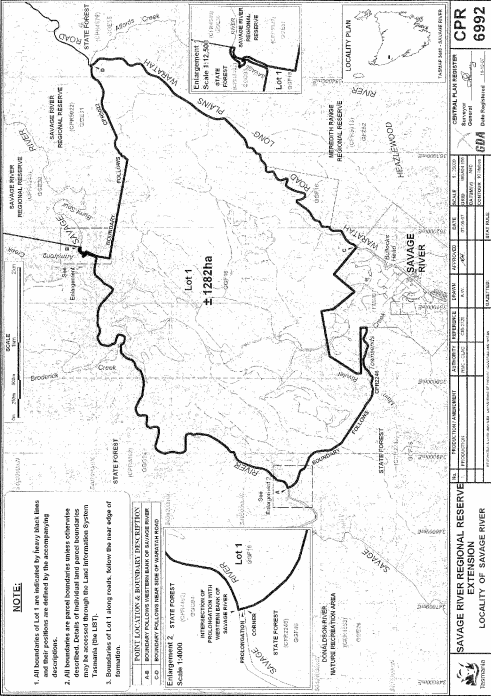
PART 8 - Savage River Regional ReserveAll that area of land comprising about 1 282 hectares, shown as Lot 1 and bounded by a heavy black line on Plan 6992 in the Central Plan Register, a reduced copy of which is set out, by way of illustration only, in Part 8 of Schedule 2 to this proclamation.
SCHEDULE 2 - Plans
PART 1 - Crotty Ridge Regional Reserve
PART 2 - Mount Farrell Regional Reserve
PART 3 - Mount Heemskirk Regional Reserve (First extension)
PART 4 - Mount Heemskirk Regional Reserve (Second extension)
PART 5 - Mount Heemskirk Regional Reserve (Third extension)
PART 6 - Mount Roland Regional Reserve
PART 7 - Renison Bell Regional Reserve

PART 8 - Savage River Regional Reserve
Displayed and numbered in accordance with the Rules Publication Act 1953.
Notified in the Gazette on 13 July 2011
This proclamation is administered in the Department of Primary Industries, Parks, Water and Environment.