

Mineral Resources Development (Fossicking Areas) Order 1996
I make the following order under section 116 of the Mineral Resources Development Act 1995 .
26 November 1996JOHN BESWICK
Minister for Mines
This order may be cited as the Mineral Resources Development (Fossicking Areas) Order 1996 .
This order takes effect on the day on which its making is notified in the Gazette.
In this order –Hydro-Electric Corporation means the Hydro-Electric Corporation within the meaning of the Hydro-Electric Corporation Act 1995 ;[Clause 3 Amended by No. 50 of 2013, Sched. 1, Applied:10 Dec 2013][Clause 3 Amended by No. 50 of 2013, Sched. 1, Applied:10 Dec 2013] State forest means permanent timber production zone land within the meaning of the Forest Management Act 2013 .
The areas of land specified in Parts 1-11 of Schedule 1 to this order are declared to be fossicking areas for the purpose of the Mineral Resources Development Act 1995 .
SCHEDULE 1 - Fossicking areas
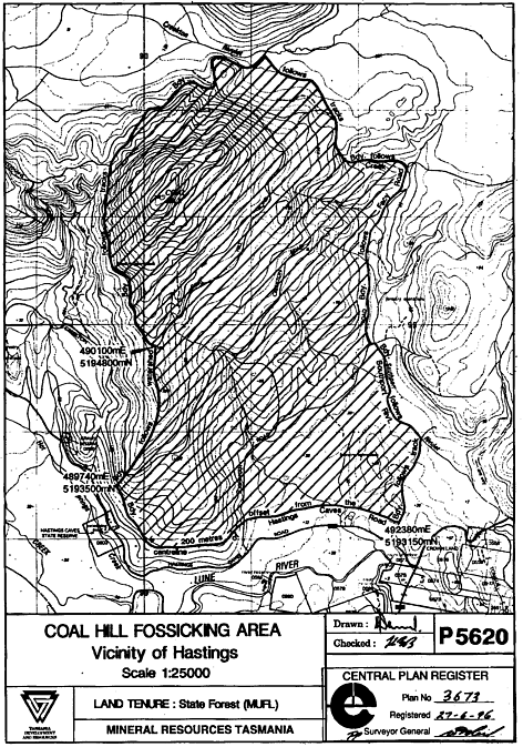
PART 1 - Coal Hill fossicking areaAll that area of State forest in the vicinity of Hastings shown hatched and bounded by heavy black lines on Plan No. 3673 in the Central Plan Register, a reduced copy of which is set out, by way of illustration only, in Part 1 of Schedule 2 to this order.
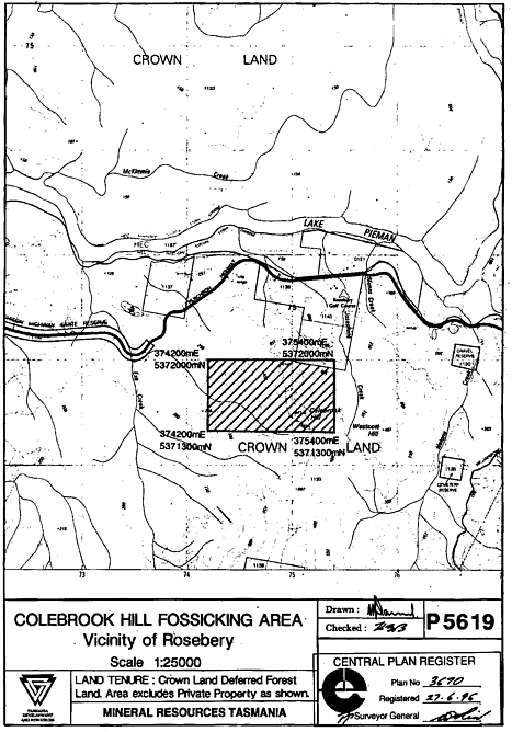
PART 2 - Colebrook Hill fossicking areaAll that area of Crown land in the vicinity of Rosebery shown hatched and bounded by heavy black lines on Plan No. 3670 in the Central Plan Register, a reduced copy of which is set out, by way of illustration only, in Part 2 of Schedule 2 to this order.
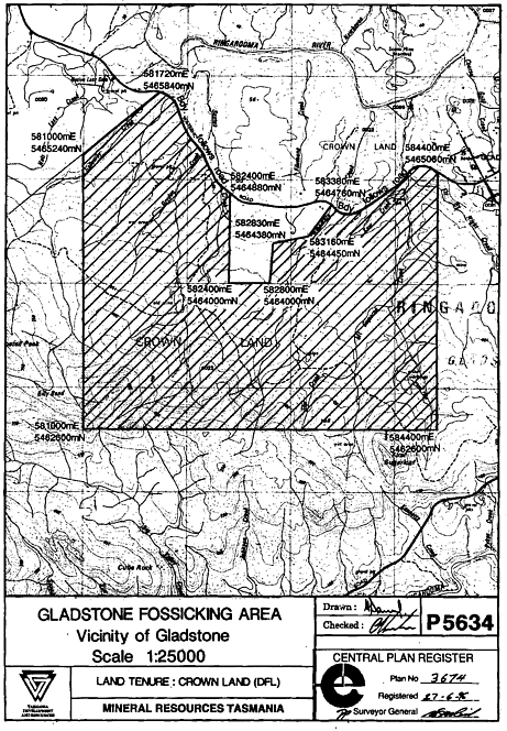
PART 3 - Gladstone fossicking areaAll that area of Crown land in the vicinity of Gladstone shown hatched and bounded by heavy black lines on Plan No. 3674 in the Central Plan Register, a reduced copy of which is set out, by way of illustration only, in Part 3 of Schedule 2 to this order.
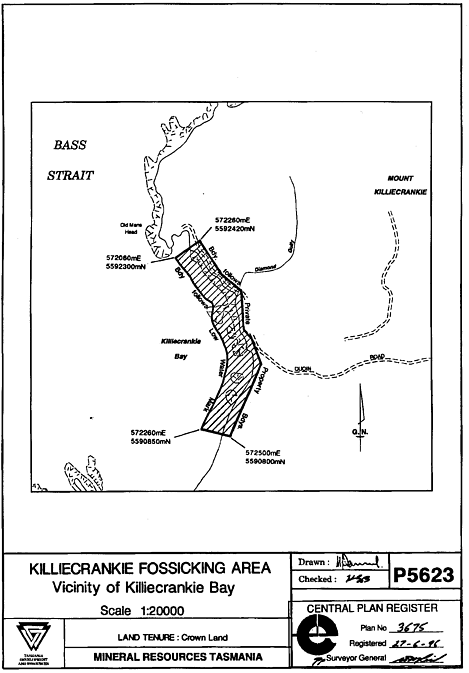
PART 4 - Killiecrankie fossicking areaAll that area of Crown land in the vicinity of Killiecrankie Bay shown hatched and bounded by heavy black lines on Plan No. 3675 in the Central Plan Register, a reduced copy of which is set out, by way of illustration only, in Part 4 of Schedule 2 to this order.
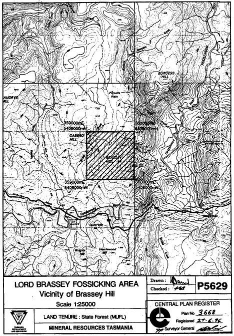
PART 5 - Lord Brassey fossicking areaAll that area of State forest in the vicinity of Brassey Hill shown hatched and bounded by heavy black lines on Plan No. 3668 in the Central Plan Register, a reduced copy of which is set out, by way of illustration only, in Part 5 of Schedule 2 to this order.
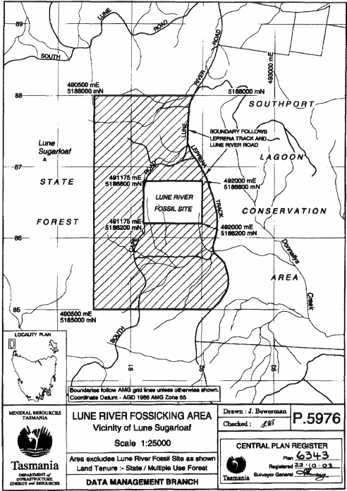
PART 6 - Lune River fossicking area[Part 6 of Schedule 1 Amended by S.R. 2003, No. 155, Applied:17 Dec 2003] All that area of State forest in the vicinity of Lune Sugarloaf shown hatched and bounded by heavy black lines, excluding the area identified as Lune River Fossil Site, on Plan No. 6343 in the Central Plan Register, a reduced copy of which is set out, by way of illustration only, in Part 6 of Schedule 2 to this order.
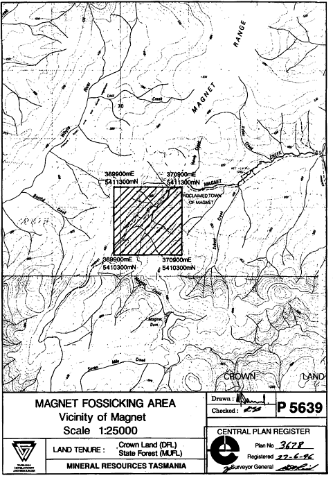
PART 7 - Magnet fossicking areaAll that area of Crown land and State forest in the vicinity of Magnet shown hatched and bounded by heavy black lines on Plan No. 3678 in the Central Plan Register, a reduced copy of which is set out, by way of illustration only, in Part 7 of Schedule 2 to this order.
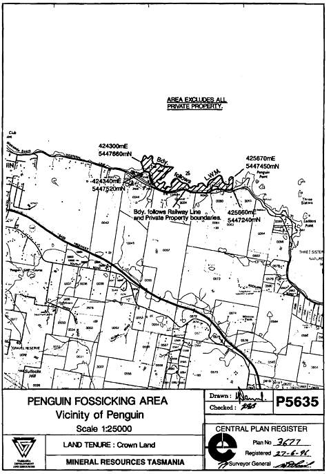
PART 8 - Penguin fossicking areaAll that area of Crown land in the vicinity of Penguin shown hatched and bounded by heavy black lines on Plan No. 3677 in the Central Plan Register, a reduced copy of which is set out, by way of illustration only, in Part 8 of Schedule 2 to this order.
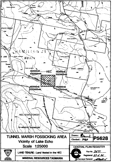
PART 9 - Tunnel Marsh fossicking areaAll that area of land in the vicinity of Lack Echo vested in the Hydro-Electric Corporation and shown hatched and bounded by heavy black lines on Plan No. 3671 in the Central Plan Register, a reduced copy of which is set out, by way of illustration only, in Part 9 of Schedule 2 to this order.
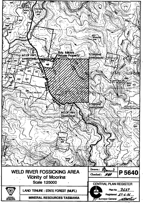
PART 10 - Weld River fossicking areaAll that area of State forest in the vicinity of Moorina shown hatched and bounded by heavy black lines on Plan No. 3669 in the Central Plan Register, a reduced copy of which is set out, by way of illustration only, in Part 10 of Schedule 2 to this order.
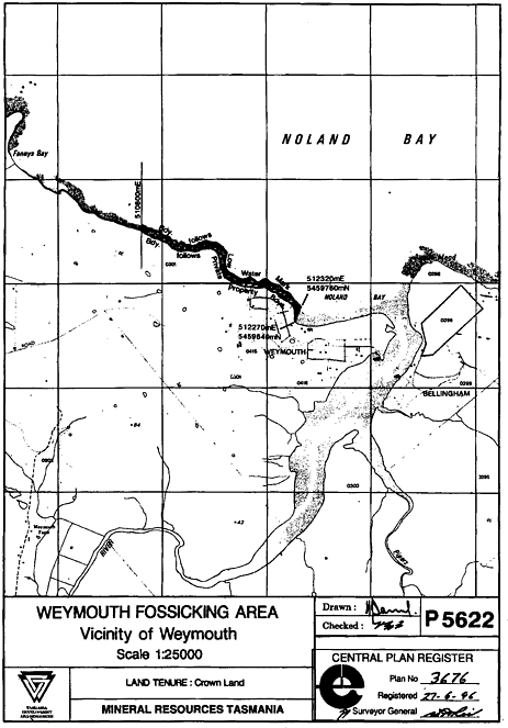
PART 11 - Weymouth fossicking areaAll that area of Crown land in the vicinity of Weymouth shown hatched and bounded on Plan No. 3676 in the Central Plan Register, a reduced copy of which is set out, by way of illustration only, in Part 11 of Schedule 2 to this order.
SCHEDULE 2 - Plans
PART 1 - Coal Hill fossicking area
PART 2 - Colebrook Hill fossicking area
PART 3 - Gladstone fossicking area
PART 4 - Killiecrankie fossicking area
PART 5 - Lord Brassey fossicking area
PART 6 - Lune River fossicking area[Part 6 of Schedule 2 Substituted by S.R. 2003, No. 155, Applied:17 Dec 2003]
PART 7 - Magnet fossicking area
PART 8 - Penguin fossicking area
PART 9 - Tunnel Marsh fossicking area
PART 10 - Weld River fossicking area
PART 11 - Weymouth fossicking area
Displayed and numbered in accordance with the Rules Publication Act 1953.
Notified in the Gazette on 4 December 1996
This order is administered in Tasmania Development and Resources.