Government House Land Act 1964
An Act to dedicate certain land and reserve it as a site for the residence of the Governor
Be it enacted by His Excellency the Governor of Tasmania, by and with the advice and consent of the Legislative Council and House of Assembly, in Parliament assembled, as follows:
This Act may be cited as the Government House Land Act 1964 .
2. Dedication of Government House land
The piece of land that is described in Schedule 1 is by force of this section –and shall not be used for any other purpose.(a) dedicated for the purpose of being used as a site for the residence of the Governor and for purposes incidental thereto; and(ab) [Section 2 Amended by No. 14 of 2017, s. 4, Applied:13 Jun 2017] dedicated for the purpose of being used, including by leasing out of part of the land or the use under licence, or by other authority, of part of the land, to raise revenue to be applied for the maintenance and preservation of the site and the residence; and(b) reserved for all time for those purposes –
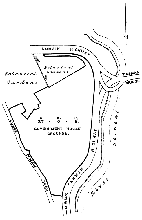
SCHEDULE 1 - City of Hobart[Schedule 1 Amended by No. 58 of 2002, Sched. 4, Applied:05 Mar 2003]
37 A. 8P. | Government House Grounds. | Commencing at a point distant 16 feet 4½ inches south-easterly from State permanent mark Number 11 on the Lower Domain Road and bounded on the south-west and north-west by 796 feet 10 inches north-westerly and north-easterly in several bearings along that road again on the south-west and on the west by 760 feet 6¾ inches north-westerly and northerly in several bearings again along that road on the north-east and again on the north-west by 245 feet 1¾ inches south-easterly and north-easterly in several bearings along land vested in the Botanical Gardens Board within the meaning of the Royal Tasmanian Botanical Gardens Act 2002 again on the north-east by 144 feet 9¼ inches south-easterly in two bearings again along that land on the south-east by 82 feet 1½ inches south-westerly in two bearings again along that land again on the north-east by 123 feet 5 inches south-easterly again along that land again on the north-west and again on the north-east by 278 feet 8 inches north-easterly and south-easterly in several bearings again along that land again on the south-west by 39 feet 11¼ inches north-westerly again along that land again on the north-west by 49 feet 11¾ inches north-easterly again along that land again on the south-west by 175 feet 11¼ inches north-westerly again along that land again on the north-west by 254 feet 7½ inches north-easterly again along that land again on the north-east by 10 inches south-easterly again along that land again on the north-west by 675 feet 11¼ inches north-easterly again along that land again on the south-west and on the south by 764 feet ¼ inch north-westerly and westerly in several bearings again along that land to the Northern Outlet Road on the north again on the north-east and again on the south-east by 3 041 feet 11¼ inches easterly south-easterly and south-westerly in several bearings along the Northern Outlet Road aforesaid and along the Tasman Highway and thence again on the south-west by 171 feet 1½ inches north-westerly along part of the Queens Domain (occupied by Police Department) to the point of commencement, being the area of land shown on Plan Number 965 filed and registered in the office of the Surveyor-General and Secretary for Lands at Hobart and delineated on the plan set forth in Schedule 2 and therein bounded by heavy black lines. |
SCHEDULE 2 - City of Hobart