

Housing Land Supply (Sulphur Creek) Order 2026
I make the following order under section 4 of the Housing Land Supply Act 2018 .
9 June 2026K. J. VINCENT
Minister for Housing and Planning
This order may be cited as the Housing Land Supply (Sulphur Creek) Order 2026 .
This order takes effect on the day on which its making is notified in the Gazette.
In this order –Act means the Housing Land Supply Act 2018 ;grid reference means the grid reference taken from the Universal Grid Reference System used in Tasmania and based on the Geocentric Datum of Australia (also known as GDA94) as notified in the Commonwealth of Australia Gazette No. GN 35, 6 September 1995.
4. Declaration of housing supply land
For section 4(1) of the Act, the area of land specified in Schedule 1 is declared to be housing supply land.
5. Declaration of intended zone
For section 4(2) of the Act, the intended zone in relation to the area of land declared to be housing supply land by clause 4 is declared to be the General Residential Zone referred to in the applicable planning scheme.
SCHEDULE 1 - Area of LandThe area of land –
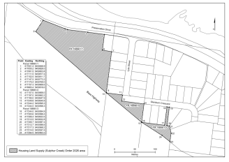
(a) situated adjacent to the roundabout at the junction of Bass Highway and Preservation Drive, Sulphur Creek in Tasmania; and(b) forming part of the land described in certificate of title Volume 188961, Folios 1, 2 and 3 of the Register kept under section 33 of the Land Titles Act 1980 ; and(c) enclosed within the boundaries made by drawing imaginary lines between the following grid references:(i) for the part of the land described in certificate of title Volume 188961, Folio 1 –(A) from 417001.4E 5450846.9N to 417055.2E 5450826.0N; and(B) from 417055.2E 5450826.0N to 417061.5E 5450823.8N; and(C) from 417061.5E 5450823.8N to 417111.5E 5450817.4N; and(D) from 417111.5E 5450817.4N to 417152.5E 5450811.7N; and(E) from 417152.5E 5450811.7N to 417147.5E 5450773.3N; and(F) from 417147.5E 5450773.3N to 417170.4E 5450769.0N; and(G) from 417170.4E 5450769.0N to 417157.3E 5450668.6N; and(H) from 417157.3E 5450668.6N to 416983.4E 5450819.0N;(ii) for the part of the land described in certificate of title Volume 188961, Folio 2 –(A) from 417157.0E 5450668.0N to 417197.0E 5450662.2N; and(B) from 417197.0E 5450662.2N to 417195.0E 5450647.9N; and(C) from 417195.0E 5450647.9N to 417249.8E 5450640.8N; and(D) from 417249.8E 5450640.8N to 417244.2E 5450595.3N; and(E) from 417244.2E 5450595.3N to 417244.5E 5450596.3N;(iii) for the part of the land described in certificate of title Volume 188961, Folio 3 –(A) from 417244.0E 5450594.9N to 417300.6E 5450588.4N; and(B) from 417300.6E 5450588.4N to 417306.4E 5450633.5N; and(C) from 417306.4E 5450633.5N to 417312.5E 5450632.8N; and(D) from 417312.5E 5450632.8N to 417306.7E 5450587.4N; and(E) from 417306.7E 5450587.4N to 417312.7E 5450586.6N; and(F) from 417312.7E 5450586.6N to 417317.3E 5450568.2N; and(G) from 417317.3E 5450568.2N to 417314.0E 5450547.4N; and(H) from 417314.0E 5450547.4N to 417294.5E 5450563.3N; and(d) shown as the shaded area bounded by heavy black lines on the plan set out, by way of illustration only, in Schedule 2.
SCHEDULE 2 - Plan
Displayed and numbered in accordance with the Rules Publication Act 1953.
Notified in the Gazette on 17 June 2026
This order is administered in the Department of State Growth.
EXPLANATORY NOTE
(This note is not part of the order)
This order declares –(a) an area of land between Bass Highway and Preservation Drive at Sulphur Creek to be housing supply land; and(b) the intended zone in relation to that land to be the General Residential Zone referred to in the applicable planning scheme.