

Proclamation under the Nature Conservation Act 2002
I, the Lieutenant-Governor in and over the State of Tasmania and its Dependencies in the Commonwealth of Australia, acting with the advice of the Executive Council, by this my proclamation made under section 11(2) of the Nature Conservation Act 2002 declare –
19 September 2011(a) the Crown land specified in Part 1 of Schedule 1 to this proclamation to be reserved land in the class of conservation area and give the name Blyth Point Conservation Area to that reserved land; and(b) the Crown land specified in Part 2 of Schedule 1 to this proclamation to be reserved land in the class of conservation area and give the name Bun Beetons Point Conservation Area to that reserved land; and(c) the Crown land specified in Part 3 of Schedule 1 to this proclamation to be reserved land in the class of conservation area and give the name Cape Wickham Conservation Area to that reserved land; and(d) the Crown land specified in Part 4 of Schedule 1 to this proclamation to be reserved land in the class of conservation area and give the name Coal Point Conservation Area to that reserved land; and(e) the Crown land specified in Part 5 of Schedule 1 to this proclamation to be reserved land in the class of conservation area and give the name Doctors Rocks Conservation Area to that reserved land; and(f) the Crown land specified in Part 6 of Schedule 1 to this proclamation to be reserved land in the class of conservation area and give the name Eldorado Conservation Area to that reserved land; and(g) the Crown land specified in Part 7 of Schedule 1 to this proclamation to be reserved land in the class of conservation area and give the name Forwards Beach Conservation Area to that reserved land; and(h) the Crown land specified in Part 8 of Schedule 1 to this proclamation to be reserved land in the class of conservation area and give the name Montagu Island Conservation Area to that reserved land; and(i) the Crown land specified in Part 9 of Schedule 1 to this proclamation to be reserved land in the class of conservation area and give the name Settlement Point Conservation Area to that reserved land; and(j) the Crown land specified in Part 10 of Schedule 1 to this proclamation to be reserved land in the class of conservation area and give the name Waterhouse Island Conservation Area to that reserved land; and(k) that this proclamation takes effect on the day on which its making is notified in the Gazette.
E. C. CRAWFORD
Lieutenant-Governor
By His Excellency's Command,
BRIAN WIGHTMAN
Minister for Environment, Parks and Heritage
SCHEDULE 1 - Areas of land
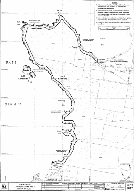
PART 1 - Blyth Point Conservation AreaAll that area of land comprising –
bounded by heavy black lines on Plan 8017 in the Central Plan Register, a reduced copy of which is set out, by way of illustration only, in Part 1 of Schedule 2 to this proclamation.(a) about 101.6 hectares, shown as Lot 1; and(b) about 6.569 hectares, shown as Lot 2 (in 2 parts) –
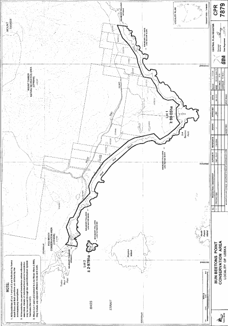
PART 2 - Bun Beetons Point Conservation AreaAll that area of land comprising –
bounded by heavy black lines on Plan 7879 in the Central Plan Register, a reduced copy of which is set out, by way of illustration only, in Part 2 of Schedule 2 to this proclamation.(a) about 99.05 hectares, shown as Lot 1; and(b) about 2.979 hectares, shown as Lot 2 –
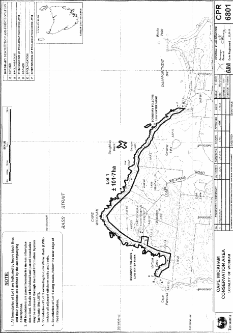
PART 3 - Cape Wickham Conservation AreaAll that area of land comprising about 101.7 hectares, shown as Lot 1 and bounded by a heavy black line on Plan 6801 in the Central Plan Register, a reduced copy of which is set out, by way of illustration only, in Part 3 of Schedule 2 to this proclamation.
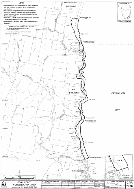
PART 4 - Coal Point Conservation AreaAll that area of land comprising about 61.3 hectares, shown as Lot 1 and bounded by a heavy black line on Plan 7336 in the Central Plan Register, a reduced copy of which is set out, by way of illustration only, in Part 4 of Schedule 2 to this proclamation.
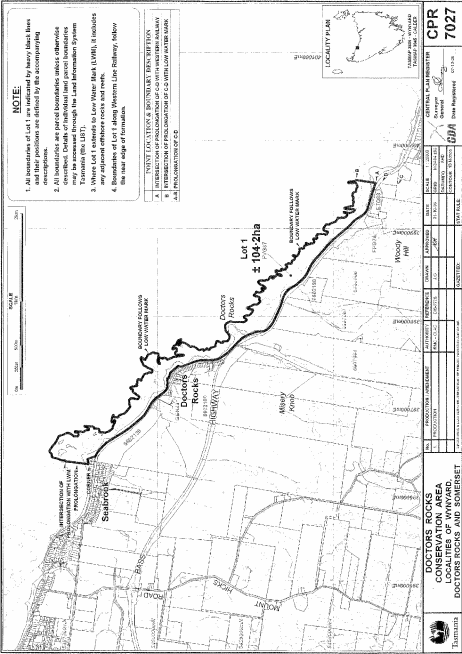
PART 5 - Doctors Rocks Conservation AreaAll that area of land comprising about 104.2 hectares, shown as Lot 1 and bounded by a heavy black line on Plan 7027 in the Central Plan Register, a reduced copy of which is set out, by way of illustration only, in Part 5 of Schedule 2 to this proclamation.
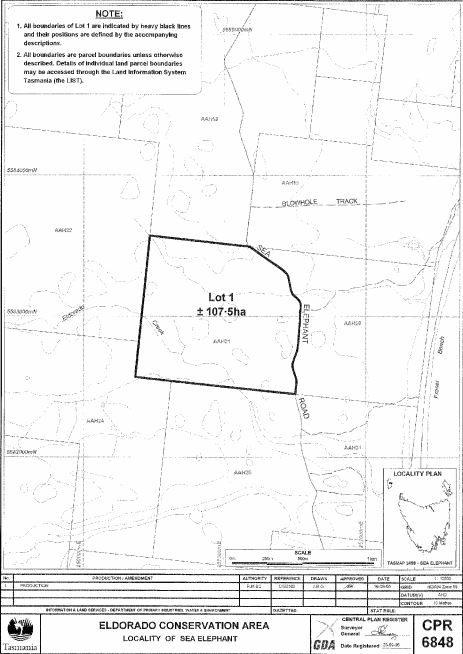
PART 6 - Eldorado Conservation AreaAll that area of land comprising about 107.5 hectares, shown as Lot 1 and bounded by a heavy black line on Plan 6848 in the Central Plan Register, a reduced copy of which is set out, by way of illustration only, in Part 6 of Schedule 2 to this proclamation.
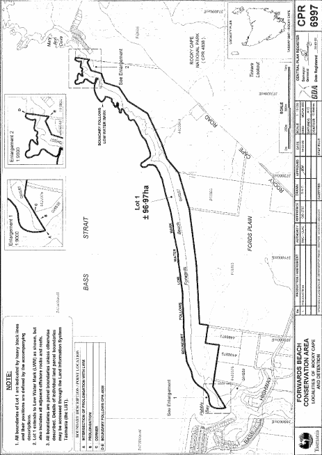
PART 7 - Forwards Beach Conservation AreaAll that area of land comprising about 96.97 hectares, shown as Lot 1 and bounded by a heavy black line on Plan 6997 in the Central Plan Register, a reduced copy of which is set out, by way of illustration only, in Part 7 of Schedule 2 to this proclamation.
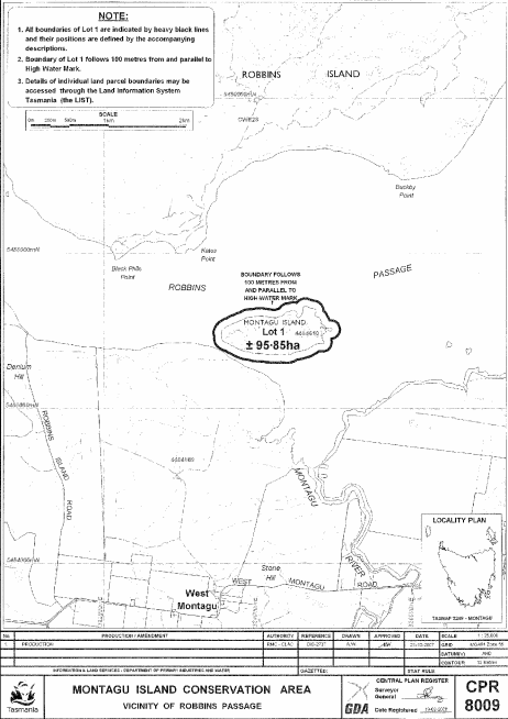
PART 8 - Montagu Island Conservation AreaAll that area of land comprising about 95.85 hectares, shown as Lot 1 and bounded by a heavy black line on Plan 8009 in the Central Plan Register, a reduced copy of which is set out, by way of illustration only, in Part 8 of Schedule 2 to this proclamation.
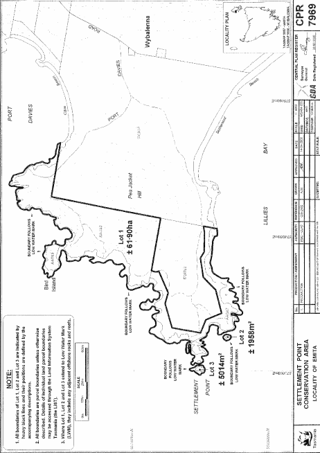
PART 9 - Settlement Point Conservation AreaAll that area of land comprising –
bounded by heavy black lines on Plan 7969 in the Central Plan Register, a reduced copy of which is set out, by way of illustration only, in Part 9 of Schedule 2 to this proclamation.(a) about 61.90 hectares, shown as Lot 1; and(b) about 1958 square metres, shown as Lot 2; and(c) about 5014 square metres, shown as Lot 2 –
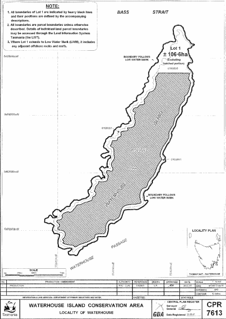
PART 10 - Waterhouse Island Conservation AreaAll that area of land comprising about 106.6 hectares, shown as Lot 1 (not including the hatched portion) and bounded by a heavy black line on Plan 7613 in the Central Plan Register, a reduced copy of which is set out, by way of illustration only, in Part 10 of Schedule 2 to this proclamation.
SCHEDULE 2 - Plans
PART 1 - Blyth Point Conservation Area
PART 2 - Bun Beetons Point Conservation Area
PART 3 - Cape Wickham Conservation Area
PART 4 - Coal Point Conservation Area
PART 5 - Doctors Rocks Conservation Area
PART 6 - Eldorado Conservation Area
PART 7 - Forwards Beach Conservation Area
PART 8 - Montagu Island Conservation Area
PART 9 - Settlement Point Conservation Area
PART 10 - Waterhouse Island Conservation Area
Displayed and numbered in accordance with the Rules Publication Act 1953.
Notified in the Gazette on 28 September 2011
This proclamation is administered in the Department of Primary Industries, Parks, Water and Environment.
EXPLANATORY NOTE
(This note is not part of the proclamation)
This proclamation declares certain areas of Crown land to be conservation areas under the Nature Conservation Act 2002 and gives a name to each of those conservation areas.