Housing Land Supply (Howrah) Order 2022
I make the following order under section 4 of the Housing Land Supply Act 2018 .
22 November 2022MICHAEL DARREL JOSEPH FERGUSON
Minister for Planning
This order may be cited as the Housing Land Supply (Howrah) Order 2022 .
This order takes effect on the day on which its making is notified in the Gazette.
In this order –Act means the Housing Land Supply Act 2018 ;applicable area means the area of land declared under clause 4 to be housing supply land;grid reference means the grid reference taken from the Universal Grid Reference System used in Tasmania and based on the Geocentric Datum of Australia (also known as the “the GDA” or “GDA94”) as defined in the Commonwealth Gazette No. GN 35, 6 September 1995.
4. Declaration of housing supply land
For the purposes of section 4(1) of the Act, the area of land specified in Schedule 1 to this order is declared to be housing supply land.
5. Declaration of intended zone
For the purposes of section 4(2) of the Act, the intended zone in relation to the applicable area is declared to be the General Residential Zone, as referred to in the applicable planning scheme.
SCHEDULE 1 - Area of landThe area of land that –
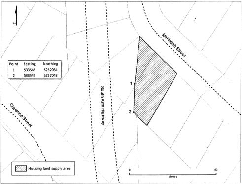
(a) is situated at Merindah Street, Howrah in Tasmania; and(b) forms part of the land as described in the certificate of title Volume 62918, Folio 35 and Folio 36 of the Register kept under section 33 of the Land Titles Act 1980 ; and(c) is within the boundary made by the following imaginary lines:(i) a line from the north-westernmost corner of the land specified in certificate of title Volume 62918, Folio 36 to grid reference 533546E 5252064N;(ii) a line between grid reference 533546E 5252064N and grid reference 533545E 5252048N;(iii) a line from grid reference 533545E 5252048N to the southernmost corner of the land specified in certificate of title Volume 62918, Folio 35;(iv) a line from the southernmost corner of the land referred to in subparagraph (iii) to the easternmost corner of the land specified in certificate of title Volume 62918, Folio 35;(v) a line from the easternmost corner of the land referred to in subparagraph (iv) to the north-westernmost corner of the land referred to in subparagraph (i); and(d) is shown as the shaded area, bounded by heavy black lines, on the plan set out, by way of illustration only, in Schedule 2 to this order.
SCHEDULE 2 - Plan
Displayed and numbered in accordance with the Rules Publication Act 1953.
Notified in the Gazette on 7 December 2022
This order is administered in the Department of Premier and Cabinet.


