

Dog Control (Sensitive Wildlife and Areas) Order 2019
I make the following order under section 19AB(2) of the Dog Control Act 2000 .
20 December 2019GUY BARNETT
Minister for Primary Industries and Water
This order may be cited as the Dog Control (Sensitive Wildlife and Areas) Order 2019 .
This order takes effect on the day on which its making is notified in the Gazette.
A reference in this order to a point is a reference to a spatial location determined in accordance with Geocentric Datum of Australia 1994.
The species of wildlife Eudyptula minor (commonly known as the Little Penguin) is specified to be sensitive wildlife.
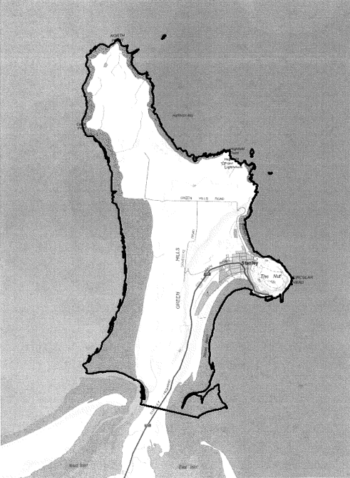
(1) The area consisting of –is specified to be a sensitive area in relation to the sensitive wildlife specified in clause 4 .(a) all the area of land, extending to the mean low water mark, that is north of an imaginary line extending directly from the point of latitude 40°47’37.67” south, longitude 145°16’51.97” east, in the east, to the point of latitude 40°47’26.24” south, longitude 145°15’52.64” east, in the west; and(b) each area of land bounded by an imaginary line encircling, at the mean low water mark, an island that is situated within 0.5 nautical miles seawards of any part of the area of land referred to in paragraph (a) ; and(c) all rocky outcrops, above the mean low water mark, that are situated within 0.5 nautical miles seawards of any part of the area of land referred to in paragraph (a) –(2) The area specified in subclause (1) is shown, for general information purposes only, on the map in Schedule 1 to this order.
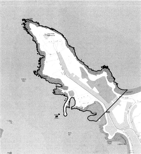
(1) The area consisting of –is specified to be a sensitive area in relation to the sensitive wildlife specified in clause 4 .(a) all the area of land, extending to the mean low water mark, that is north of an imaginary line extending directly from the point of latitude 41°3’46.54” south, longitude 146°48’13.71” east, in the north-east, to the point of latitude 41°4’1.75” south, longitude 146°47’53.95” east, in the south-west; and(b) each area of land bounded by an imaginary line encircling, at the mean low water mark, an island that is situated within 0.5 nautical miles seawards of any part of the area of land referred to in paragraph (a) ; and(c) all rocky outcrops, above the mean low water mark, that are situated within 0.5 nautical miles seawards of any part of the area of land referred to in paragraph (a) –(2) The area specified in subclause (1) is shown, for general information purposes only, on the map in Schedule 2 to this order.
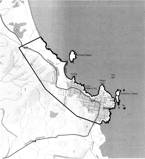
(1) The area consisting of –is specified to be a sensitive area in relation to the sensitive wildlife specified in clause 4 .(a) the area of land bounded on its seaward side by the mean low water mark and on its landward side by an imaginary line extending directly between the points specified in the following paragraphs:(i) latitude 41°52’57.87” south, longitude 148°18’14.78” east;(ii) latitude 41°52’47.45” south, longitude 148°17’33.66” east;(iii) latitude 41°52’13.00” south, longitude 148°16’38.48” east;(iv) latitude 41°51’18.93” south, longitude 148°15’50.08” east;(v) latitude 41°51’04.36” south, longitude 148°16’28.91” east; and(b) each area of land bounded by an imaginary line encircling, at the mean low water mark, an island (including Diamond Island and Governor Island) that is situated within 0.5 nautical miles seawards of any part of the area of land referred to in paragraph (a) ; and(c) all rocky outcrops, above the mean low water mark, situated within 0.5 nautical miles seawards of any part of the area of land referred to in paragraph (a) –(2) The area specified in subclause (1) is shown, for general information purposes only, on the map in Schedule 3 to this order.
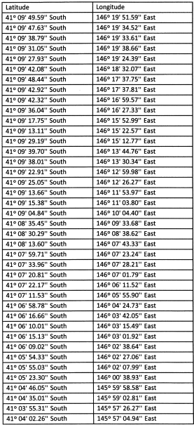
8. Sensitive area – Wynyard/Ulverstone
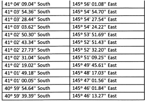
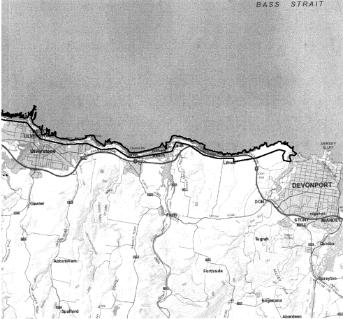
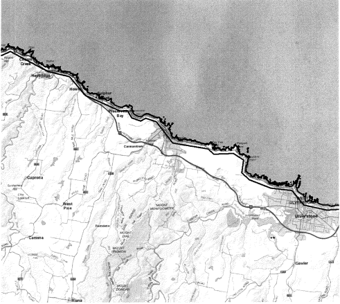
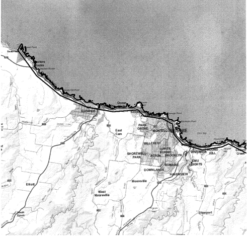
(1) The area consisting of –is specified to be a sensitive area in relation to the sensitive wildlife specified in clause 4 .(a) the area of land bounded on its seaward side by the mean low water mark and on its landward side by an imaginary line extending between the points, of latitude and longitude, specified in Part 1 of Schedule 4 to this order; and(b) each area of land bounded by an imaginary line encircling, at the mean low water mark, an island that is situated within 0.5 nautical miles seawards of any part of the area of land referred to in paragraph (a) ; and(c) all rocky outcrops, above the mean low water mark, situated within 0.5 nautical miles seawards of any part of the area of land referred to in paragraph (a) –(2) The area specified in subclause (1) is shown, for general information purposes only, on the 3 maps in Part 2 of Schedule 4 to this order.
SCHEDULE 1 - Sensitive area – Stanley
SCHEDULE 2 - Sensitive area – Low Head
SCHEDULE 3 - Sensitive area – Bicheno
SCHEDULE 4 - Sensitive area – Wynyard/Ulverstone
PART 1 - Points
PART 2 - Maps
Displayed and numbered in accordance with the Rules Publication Act 1953.
Notified in the Gazette on 25 December 2019
This order is administered in the Department of Premier and Cabinet.