

Proclamation under the Nature Conservation Act 2002
I, the Governor in and over the State of Tasmania and its Dependencies in the Commonwealth of Australia, acting with the advice of the Executive Council, by this my proclamation made under sections 11(2) and 19(2) of the Nature Conservation Act 2002 declare –
30 November 2009(a) the area of Crown land specified in Part 1 of Schedule 1 to this proclamation to be reserved land in the class of conservation area and give the name Blackman Rivulet Marine Conservation Area to that reserved land; and(b) the area of Crown land specified in Part 2 of Schedule 1 to this proclamation to be reserved land in the class of conservation area and give the name Central Channel Marine Conservation Area to that reserved land; and(c) the area of Crown land specified in Part 3 of Schedule 1 to this proclamation to be reserved land in the class of conservation area and give the name Cloudy Bay Lagoon Marine Conservation Area to that reserved land; and(d) the area of Crown land specified in Part 4 of Schedule 1 to this proclamation to be reserved land in the class of conservation area and give the name Hippolyte Rocks Marine Conservation Area to that reserved land; and(e) the area of Crown land specified in Part 5 of Schedule 1 to this proclamation to be reserved land in the class of conservation area and give the name Huon Estuary Marine Conservation Area to that reserved land; and(f) the area of Crown land specified in Part 6 of Schedule 1 to this proclamation to be reserved land in the class of conservation area and give the name Monk Bay Marine Conservation Area to that reserved land; and(g) the area of Crown land specified in Part 7 of Schedule 1 to this proclamation to be reserved land in the class of conservation area and give the name Opossum Bay Marine Conservation Area to that reserved land; and(h) the Crown land specified in Part 8 of Schedule 1 to this proclamation, being reserved land known as Port Cygnet Conservation Area, to be renamed Port Cygnet Marine Conservation Area; and(i) the area of Crown land specified in Part 9 of Schedule 1 to this proclamation to be reserved land in the class of conservation area and give the name River Derwent Marine Conservation Area to that reserved land; and(j) the area of Crown land specified in Part 10 of Schedule 1 to this proclamation to be reserved land in the class of conservation area and give the name Roberts Point Marine Conservation Area to that reserved land; and(k) the area of Crown land specified in Part 11 of Schedule 1 to this proclamation to be reserved land in the class of conservation area and give the name Simpsons Point Marine Conservation Area to that reserved land; and(l) the area of Crown land specified in Part 12 of Schedule 1 to this proclamation to be reserved land in the class of conservation area and give the name Sloping Island Marine Conservation Area to that reserved land; and(m) the area of Crown land specified in Part 13 of Schedule 1 to this proclamation to be reserved land in the class of conservation area and give the name South Arm Marine Conservation Area to that reserved land; and(n) the Crown land specified in Part 14 of Schedule 1 to this proclamation, being reserved land known as South Arm Conservation Area, to be renamed South Arm Marine Conservation Area; and(o) the area of Crown land specified in Part 15 of Schedule 1 to this proclamation to be reserved land in the class of conservation area and give the name Waterfall – Fortescue Marine Conservation Area to that reserved land; and(p) that this proclamation takes effect on the day on which its making is notified in the Gazette.
PETER G. UNDERWOOD
Governor
By His Excellency's Command,
D. E. LLEWELLYN
Minister for Primary Industries and Water
SCHEDULE 1 - Areas of land
PART 1 - Blackman Rivulet Marine Conservation AreaAll that area of land comprising about 263.1 hectares, shown as Lot 1 and bounded by a heavy black line, on Plan 8638 in the Central Plan Register, a reduced copy of which is set out, by way of illustration only, in Part 1 of Schedule 2 to this proclamation.
PART 2 - Central Channel Marine Conservation AreaAll that area of land comprising about 3443 hectares, shown as Lot 1 and bounded by heavy black lines, on Plan 8641 in the Central Plan Register, a reduced copy of which is set out, by way of illustration only, in Part 2 of Schedule 2 to this proclamation.
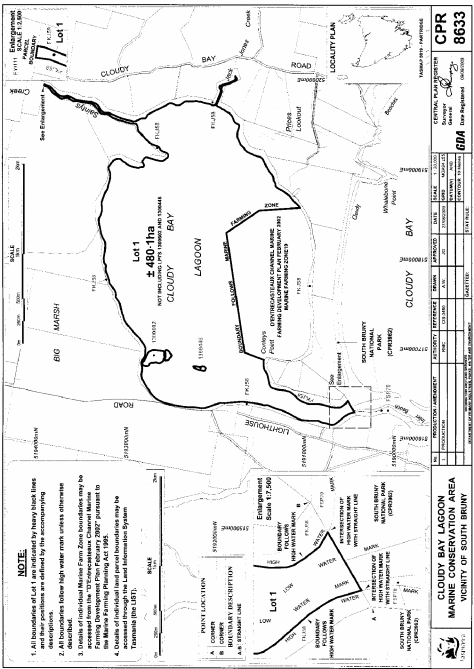
PART 3 - Cloudy Bay Lagoon Marine Conservation AreaAll that area of land comprising about 480.1 hectares, shown as Lot 1 and bounded by heavy black lines, on Plan 8633 in the Central Plan Register, a reduced copy of which is set out, by way of illustration only, in Part 3 of Schedule 2 to this proclamation.
PART 4 - Hippolyte Rocks Marine Conservation AreaAll that area of land comprising about 534.9 hectares, shown as Lot 1 and bounded by heavy black lines, on Plan 8636 in the Central Plan Register, a reduced copy of which is set out, by way of illustration only, in Part 4 of Schedule 2 to this proclamation.
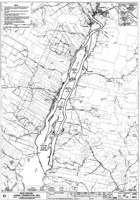
PART 5 - Huon Estuary Marine Conservation AreaAll that area of land comprising about 694.2 hectares, shown as Lot 1 and bounded by heavy black lines, on Plan 8635 in the Central Plan Register, a reduced copy of which is set out, by way of illustration only, in Part 5 of Schedule 2 to this proclamation.
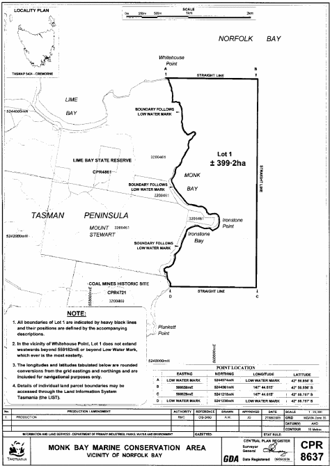
PART 6 - Monk Bay Marine Conservation AreaAll that area of land comprising about 399.2 hectares, shown as Lot 1 and bounded by a heavy black line, on Plan 8637 in the Central Plan Register, a reduced copy of which is set out, by way of illustration only, in Part 6 of Schedule 2 to this proclamation.
PART 7 - Opossum Bay Marine Conservation AreaAll that area of land comprising about 555.5 hectares, shown as Lot 1 and bounded by a heavy black line, on Plan 8639 in the Central Plan Register, a reduced copy of which is set out, by way of illustration only, in Part 7 of Schedule 2 to this proclamation.
PART 8 - Port Cygnet Marine Conservation AreaAll that area of land comprising about 103.1 hectares, shown as Lot 1 and bounded by a heavy black line, on Plan 8631 in the Central Plan Register, a reduced copy of which is set out, by way of illustration only, in Part 8 of Schedule 2 to this proclamation.
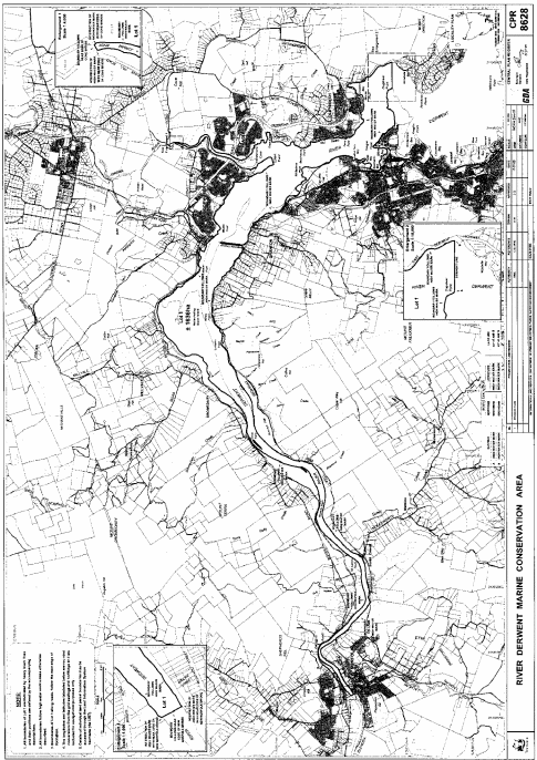
PART 9 - River Derwent Marine Conservation AreaAll that area of land comprising about 1636 hectares, shown as Lot 1 and bounded by a heavy black line, on Plan 8628 in the Central Plan Register, a reduced copy of which is set out, by way of illustration only, in Part 9 of Schedule 2 to this proclamation.
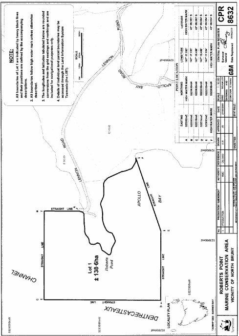
PART 10 - Roberts Point Marine Conservation AreaAll that area of land comprising about 138.6 hectares, shown as Lot 1 and bounded by a heavy black line, on Plan 8632 in the Central Plan Register, a reduced copy of which is set out, by way of illustration only, in Part 10 of Schedule 2 to this proclamation.
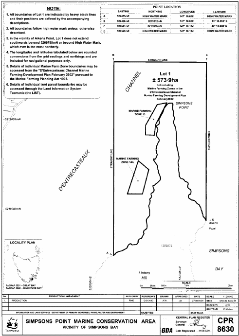
PART 11 - Simpsons Point Marine Conservation AreaAll that area of land comprising about 573.9 hectares, shown as Lot 1 and bounded by heavy black lines, on Plan 8630 in the Central Plan Register, a reduced copy of which is set out, by way of illustration only, in Part 11 of Schedule 2 to this proclamation.
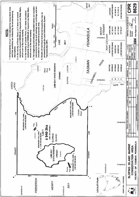
PART 12 - Sloping Island Marine Conservation AreaAll that area of land comprising about 940.3 hectares, shown as Lot 1 and bounded by heavy black lines, on Plan 8629 in the Central Plan Register, a reduced copy of which is set out, by way of illustration only, in Part 12 of Schedule 2 to this proclamation.
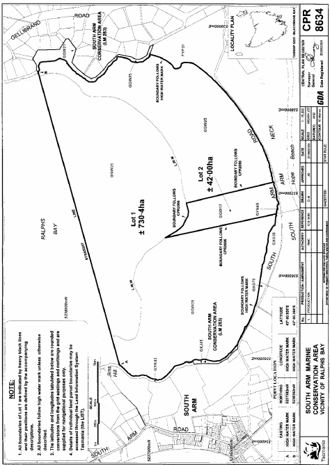
PART 13 - South Arm Marine Conservation AreaAll that area of land comprising about 42 hectares, shown as Lot 2 and bounded by a heavy black line, on Plan 8634 in the Central Plan Register, a reduced copy of which is set out, by way of illustration only, in Part 13 of Schedule 2 to this proclamation.
PART 14 - South Arm Marine Conservation AreaAll that area of land comprising about 730.4 hectares, shown as Lot 1 and bounded by a heavy black line, on Plan 8634 in the Central Plan Register, a reduced copy of which is set out, by way of illustration only, in Part 13 of Schedule 2 to this proclamation.
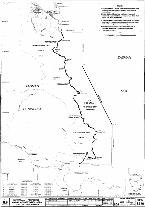
PART 15 - Waterfall – Fortescue Marine Conservation AreaAll that area of land comprising about 1230 hectares, shown as Lot 1 and bounded by a heavy black line, on Plan 8640 in the Central Plan Register, a reduced copy of which is set out, by way of illustration only, in Part 14 of Schedule 2 to this proclamation.
SCHEDULE 2 - Plans
PART 1 - Blackman Rivulet Marine Conservation Area

PART 2 - Central Channel Marine Conservation Area

PART 3 - Cloudy Bay Lagoon Marine Conservation Area
PART 4 - Hippolyte Rocks Marine Conservation Area

PART 5 - Huon Estuary Marine Conservation Area
PART 6 - Monk Bay Marine Conservation Area
PART 7 - Opossum Bay Marine Conservation Area

PART 8 - Port Cygnet Marine Conservation Area

PART 9 - River Derwent Marine Conservation Area
PART 10 - Roberts Point Marine Conservation Area
PART 11 - Simpsons Point Marine Conservation Area
PART 12 - Sloping Island Marine Conservation Area
PART 13 - South Arm Marine Conservation Area
PART 14 - Waterfall – Fortescue Marine Conservation Area
Displayed and numbered in accordance with the Rules Publication Act 1953.
Notified in the Gazette on 9 December 2009
This proclamation is administered in the Department of Primary Industries, Parks, Water and Environment.