

Proclamation under the Nature Conservation Act 2002
I, the Governor in and over the State of Tasmania and its Dependencies in the Commonwealth of Australia, acting with the advice of the Executive Council, by this my proclamation made under sections 11(2) and 19(2) of the Nature Conservation Act 2002 declare –
3 December 2007(a) the Crown land specified in Part 1 of Schedule 1 to this proclamation to be reserved land in the class of game reserve and give the name Petrel Islands Game Reserve to that reserved land; and(b) the Crown land specified in Part 2 of Schedule 1 to this proclamation to be reserved land in the class of game reserve and give the name Stack Island Game Reserve to that reserved land; and(c) the Crown land specified in Part 3 of Schedule 1 to this proclamation to be reserved land in the class of game reserve and give the name Actaeon Island Game Reserve to that reserved land; and(d) the Crown land specified in Part 4 of Schedule 1 to this proclamation to be reserved land in the class of conservation area and give the name Tatlows Beach Conservation Area to that reserved land; and(e) the Crown land specified in Part 5 of Schedule 1 to this proclamation to be reserved land in the class of conservation area and give the name Mount Faulkner Conservation Area to that reserved land; and(f) the Crown land specified in Part 6 of Schedule 1 to this proclamation to be reserved land in the class of conservation area and give the name Molesworth Conservation Area to that reserved land; and(g) the Crown land specified in Part 7 of Schedule 1 to this proclamation to be reserved land in the class of conservation area and give the name Lillico Beach Conservation Area to that reserved land; and(h) the Crown land specified in Part 8 of Schedule 1 to this proclamation to be reserved land in the class of conservation area and give the name Coles Bay Conservation Area to that reserved land; and(i) the Crown land specified in Part 9 of Schedule 1 to this proclamation to be reserved land in the class of conservation area and give the name Kelvedon Beach Conservation Area to that reserved land; and(j) the Crown land specified in Part 10 of Schedule 1 to this proclamation to be reserved land in the class of conservation area and give the name Mayfield Bay Conservation Area to that reserved land; and(k) the Crown land specified in Part 11 of Schedule 1 to this proclamation to be reserved land in the class of conservation area and give the name Swansea Conservation Area to that reserved land; and(l) the Crown land specified in Part 12 of Schedule 1 to this proclamation to be reserved land in the class of conservation area and give the name Whalers Lookout Conservation Area to that reserved land; and(m) the Crown land specified in Part 13 of Schedule 1 to this proclamation to be reserved land in the class of conservation area and give the name Pelican Island Conservation Area to that reserved land; and(n) the Crown land specified in Part 14 of Schedule 1 to this proclamation to be reserved land in the class of conservation area and give the name Port Cygnet Conservation Area to that reserved land; and(o) the Crown land specified in Part 15 of Schedule 1 to this proclamation to be reserved land in the class of conservation area and give the name Randalls Bay Conservation Area to that reserved land; and(p) the Crown land specified in Part 16 of Schedule 1 to this proclamation to be reserved land in the class of conservation area and give the name Surveyors Bay Conservation Area to that reserved land; and(q) the Crown land specified in Part 17 of Schedule 1 to this proclamation to be reserved land in the class of conservation area and give the name Cape De La Sortie Conservation Area to that reserved land; and(r) the Crown land specified in Part 18 of Schedule 1 to this proclamation to be reserved land in the class of conservation area and give the name Fossil Cove Conservation Area to that reserved land; and(s) the Crown land specified in Part 19 of Schedule 1 to this proclamation to be reserved land in the class of conservation area and give the name Mount Royal Conservation Area to that reserved land; and(t) the Crown land specified in Part 20 of Schedule 1 to this proclamation to be reserved land in the class of conservation area and give the name Marion Beach Conservation Area to that reserved land; and(u) the Crown land specified in Part 21 of Schedule 1 to this proclamation to be reserved land in the class of conservation area and give the name Lake Dulverton Conservation Area to that reserved land; and(v) the Crown land specified in Part 22 of Schedule 1 to this proclamation to be reserved land in the class of conservation area and give the name Gravelly Ridge Conservation Area to that reserved land; and(w) the Crown land specified in Part 23 of Schedule 1 to this proclamation to be reserved land in the class of conservation area and give the name Brother and Sister Conservation Area to that reserved land; and(x) the Crown land specified in Part 24 of Schedule 1 to this proclamation to be reserved land in the class of conservation area and give the name Fossil Bluff Conservation Area to that reserved land; and(y) the Crown land specified in Part 25 of Schedule 1 to this proclamation to be reserved land in the class of conservation area and give the name Sisters Island Conservation Area to that reserved land; and(z) the Crown land specified in Part 26 of Schedule 1 to this proclamation to be reserved land in the class of conservation area and give the name Table Cape Conservation Area to that reserved land; and(za) the Crown land specified in Part 27 of Schedule 1 to this proclamation to be reserved land in the class of nature recreation area and give the name Coningham Nature Recreation Area to that reserved land; and(zb) the Crown land specified in Part 28 of Schedule 1 to this proclamation to be reserved land in the class of regional reserve and give the name Leven Canyon Regional Reserve to that reserved land; and(zc) the Crown land specified in Part 29 of Schedule 1 to this proclamation to be reserved land in the class of regional reserve and give the name Dip Range Regional Reserve to that reserved land; and(zd) the Crown land specified in Part 30 of Schedule 1 to this proclamation to be reserved land in the class of regional reserve and give the name Meredith Range Regional Reserve to that reserved land; and(ze) the Crown land specified in Part 31 of Schedule 1 to this proclamation to be reserved land in the class of regional reserve and give the name Mount Dundas Regional Reserve to that reserved land; and(zf) the Crown land specified in Part 32 of Schedule 1 to this proclamation, being reserved land known as Mt Faulkner Conservation Area, to be renamed Mount Faulkner Conservation Area; and(zg) that this proclamation takes effect on the day on which its making is notified in the Gazette.
W. J. E. COX
Governor
By His Excellency's Command,
D. E. LLEWELLYN
Minister for Primary Industries and Water
SCHEDULE 1 - Areas of Land
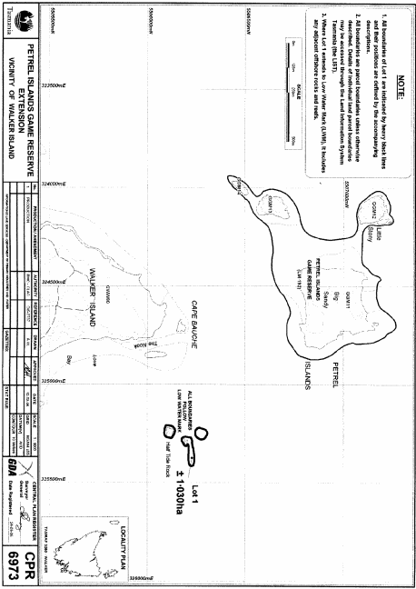
PART 1 - Petrel Islands Game ReserveAll those areas of land comprising about 1.03 hectares, shown as Lot 1 and being 3 separate areas each bounded by a heavy black line on Plan 6973 in the Central Plan Register, a reduced copy of which is set out, by way of illustration only, in Part 1 of Schedule 2 to this proclamation.
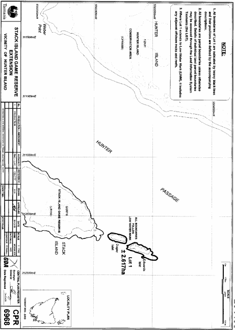
PART 2 - Stack Island Game ReserveAll those areas of land comprising about 2.617 hectares, shown as Lot 1 and bounded by heavy black lines on Plan 6968 in the Central Plan Register, a reduced copy of which is set out, by way of illustration only, in Part 2 of Schedule 2 to this proclamation.
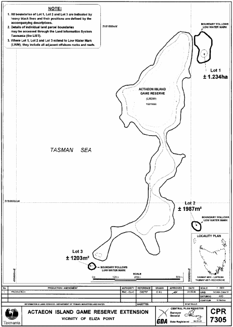
PART 3 - Actaeon Island Game ReserveAll those areas of land comprising –
and bounded by heavy black lines on Plan 7305 in the Central Plan Register, a reduced copy of which is set out, by way of illustration only, in Part 3 of Schedule 2 to this proclamation.(a) about 1.234 hectares, shown as Lot 1; and(b) about 1 987 square metres, shown as Lot 2; and(c) about 1 203 square metres, shown as Lot 3 –
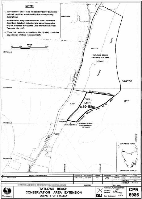
PART 4 - Tatlows Beach Conservation AreaAll that area of land comprising about 10.18 hectares, shown as Lot 1 and bounded by a heavy black line on Plan 6986 in the Central Plan Register, a reduced copy of which is set out, by way of illustration only, in Part 4 of Schedule 2 to this proclamation.
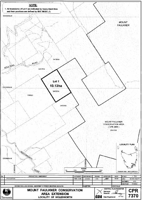
PART 5 - Mount Faulkner Conservation Area – Plan 7370All that area of land comprising about 10.13 hectares, shown as Lot 1 and bounded by a heavy black line on Plan 7370 in the Central Plan Register, a reduced copy of which is set out, by way of illustration only, in Part 5 of Schedule 2 to this proclamation.
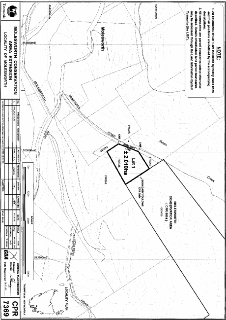
PART 6 - Molesworth Conservation AreaAll that area of land comprising about 2.01 hectares, shown as Lot 1 and bounded by a heavy black line on Plan 7369 in the Central Plan Register, a reduced copy of which is set out, by way of illustration only, in Part 6 of Schedule 2 to this proclamation.
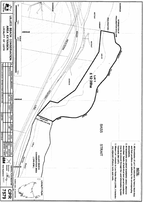
PART 7 - Lillico Beach Conservation AreaAll that area of land comprising about 12.35 hectares, shown as Lot 1 and bounded by a heavy black line on Plan 7579 in the Central Plan Register, a reduced copy of which is set out, by way of illustration only, in Part 7 of Schedule 2 to this proclamation.
PART 8 - Coles Bay Conservation Area
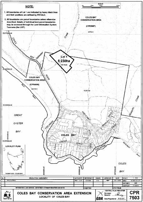
1. All that area of land comprising about 5.23 hectares, shown as Lot 1 and bounded by a heavy black line on Plan 7503 in the Central Plan Register, a reduced copy of which is set out, by way of illustration only, in Part 8 of Schedule 2 to this proclamation.
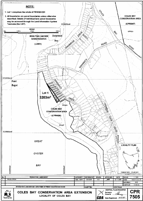
2. All that area of land comprising about 3 203 square metres, shown as Lot 1 and bounded by a heavy black line on Plan 7505 in the Central Plan Register, a reduced copy of which is set out, by way of illustration only, in Part 9 of Schedule 2 to this proclamation.
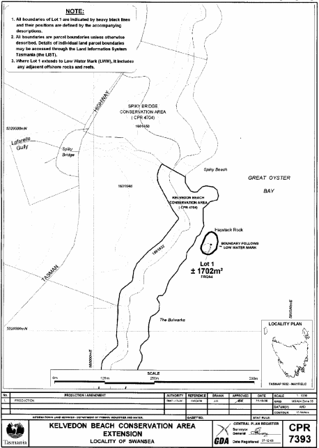
PART 9 - Kelvedon Beach Conservation AreaAll that area of land comprising about 1 702 square metres, shown as Lot 1 and bounded by a heavy black line on Plan 7393 in the Central Plan Register, a reduced copy of which is set out, by way of illustration only, in Part 10 of Schedule 2 to this proclamation.
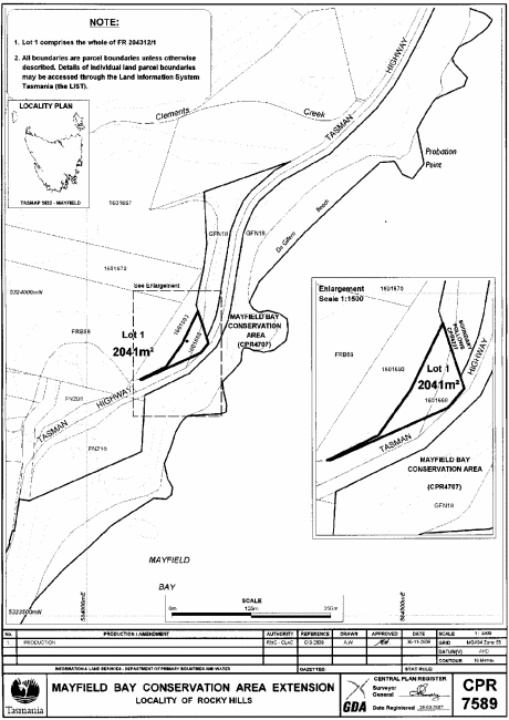
PART 10 - Mayfield Bay Conservation AreaAll that area of land comprising about 2 041 square metres, shown as Lot 1 and bounded by a heavy black line on Plan 7589 in the Central Plan Register, a reduced copy of which is set out, by way of illustration only, in Part 11 of Schedule 2 to this proclamation.
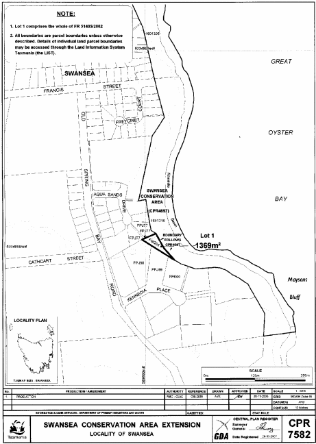
PART 11 - Swansea Conservation AreaAll that area of land comprising about 1 369 square metres, shown as Lot 1 and bounded by a heavy black line on Plan 7582 in the Central Plan Register, a reduced copy of which is set out, by way of illustration only, in Part 12 of Schedule 2 to this proclamation.
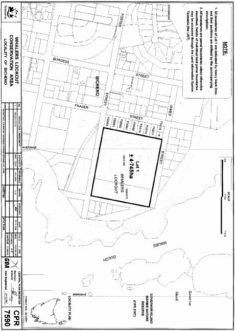
PART 12 - Whalers Lookout Conservation AreaAll that area of land comprising about 4.745 hectares, shown as Lot 1 and bounded by a heavy black line on Plan 7590 in the Central Plan Register, a reduced copy of which is set out, by way of illustration only, in Part 13 of Schedule 2 to this proclamation.
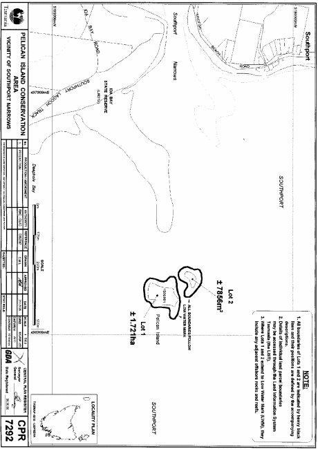
PART 13 - Pelican Island Conservation AreaAll those areas of land comprising –
and bounded by heavy black lines on Plan 7292 in the Central Plan Register, a reduced copy of which is set out, by way of illustration only, in Part 14 of Schedule 2 to this proclamation.(a) about 1.721 hectares, shown as Lot 1; and(b) about 7 856 square metres, shown as Lot 2 –
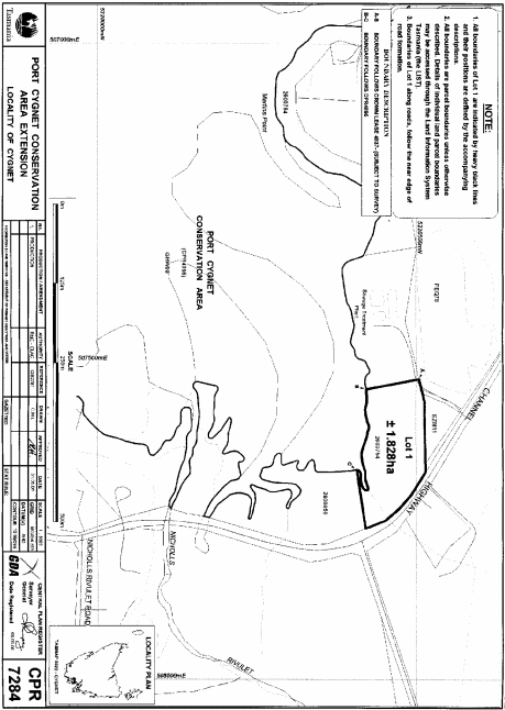
PART 14 - Port Cygnet Conservation AreaAll that area of land comprising about 1.828 hectares, shown as Lot 1 and bounded by a heavy black line on Plan 7284 in the Central Plan Register, a reduced copy of which is set out, by way of illustration only, in Part 15 of Schedule 2 to this proclamation.
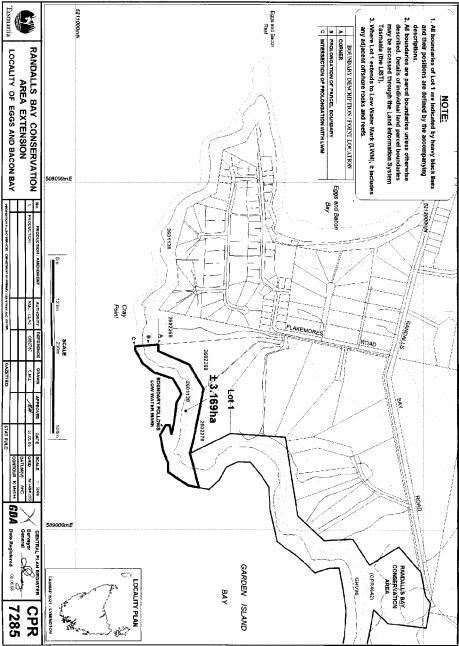
PART 15 - Randalls Bay Conservation AreaAll that area of land comprising about 3.169 hectares, shown as Lot 1 and bounded by a heavy black line on Plan 7285 in the Central Plan Register, a reduced copy of which is set out, by way of illustration only, in Part 16 of Schedule 2 to this proclamation.
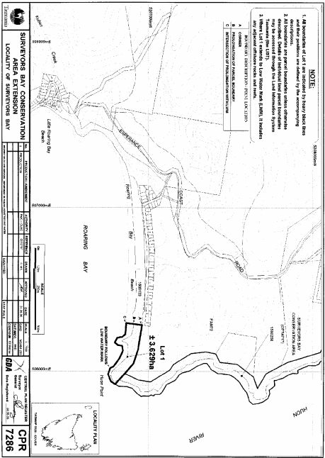
PART 16 - Surveyors Bay Conservation AreaAll that area of land comprising about 3.629 hectares, shown as Lot 1 and bounded by a heavy black line on Plan 7286 in the Central Plan Register, a reduced copy of which is set out, by way of illustration only, in Part 17 of Schedule 2 to this proclamation.
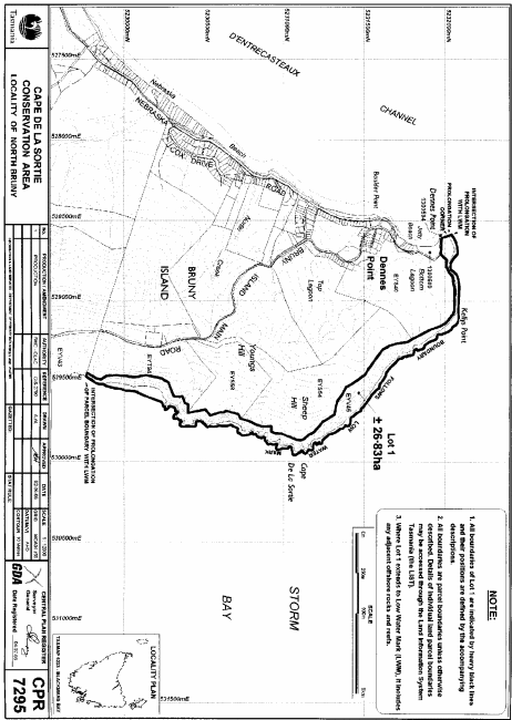
PART 17 - Cape De La Sortie Conservation AreaAll that area of land comprising about 26.83 hectares, shown as Lot 1 and bounded by a heavy black line on Plan 7295 in the Central Plan Register, a reduced copy of which is set out, by way of illustration only, in Part 18 of Schedule 2 to this proclamation.
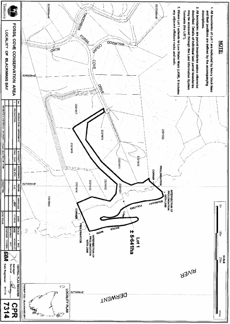
PART 18 - Fossil Cove Conservation AreaAll that area of land comprising about 5.641 hectares, shown as Lot 1 and bounded by a heavy black line on Plan 7314 in the Central Plan Register, a reduced copy of which is set out, by way of illustration only, in Part 19 of Schedule 2 to this proclamation.
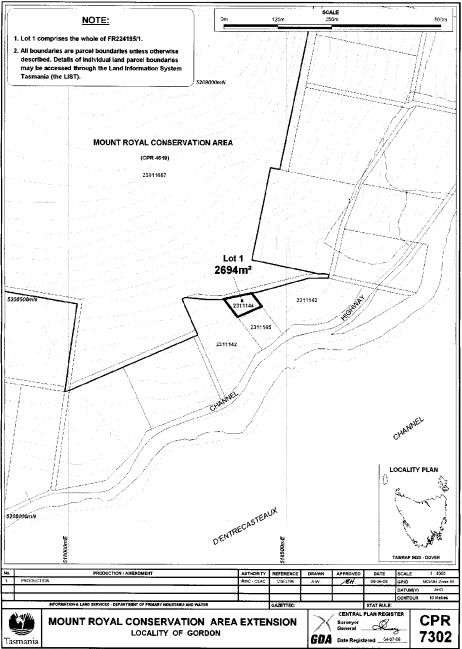
PART 19 - Mount Royal Conservation AreaAll that area of land comprising about 2 694 square metres, shown as Lot 1 and bounded by a heavy black line on Plan 7302 in the Central Plan Register, a reduced copy of which is set out, by way of illustration only, in Part 20 of Schedule 2 to this proclamation.
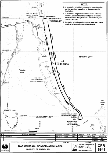
PART 20 - Marion Beach Conservation AreaAll that area of land comprising about 36.36 hectares, shown as Lot 1 and bounded by a heavy black line on Plan 6941 in the Central Plan Register, a reduced copy of which is set out, by way of illustration only, in Part 21 of Schedule 2 to this proclamation.
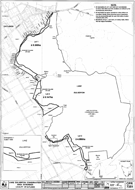
PART 21 - Lake Dulverton Conservation AreaAll those areas of land comprising –
and bounded by heavy black lines on Plan 7351 in the Central Plan Register, a reduced copy of which is set out, by way of illustration only, in Part 22 of Schedule 2 to this proclamation.(a) about 5.305 hectares, shown as Lot 1; and(b) about 5.147 hectares, shown as Lot 2; and(c) about 4.086 hectares, shown as Lot 3 –
PART 22 - Gravelly Ridge Conservation AreaAll those areas of land comprising –
and bounded by heavy black lines on Plan 7346 in the Central Plan Register, a reduced copy of which is set out, by way of illustration only, in Part 23 of Schedule 2 to this proclamation.(a) about 6 523 square metres, shown as Lot 1; and(b) about 9 100 square metres, shown as Lot 2 –
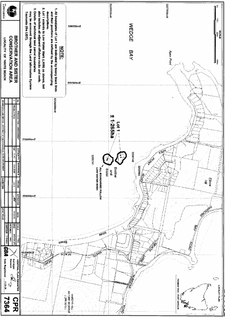
PART 23 - Brother and Sister Conservation AreaAll those areas of land comprising about 1.265 hectares, shown as Lot 1 and bounded by heavy black lines on Plan 7364 in the Central Plan Register, a reduced copy of which is set out, by way of illustration only, in Part 24 of Schedule 2 to this proclamation.
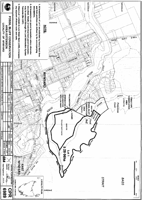
PART 24 - Fossil Bluff Conservation AreaAll that area of land comprising about 28.96 hectares, shown as Lot 1 and bounded by a heavy black line on Plan 6989 in the Central Plan Register, a reduced copy of which is set out, by way of illustration only, in Part 25 of Schedule 2 to this proclamation.
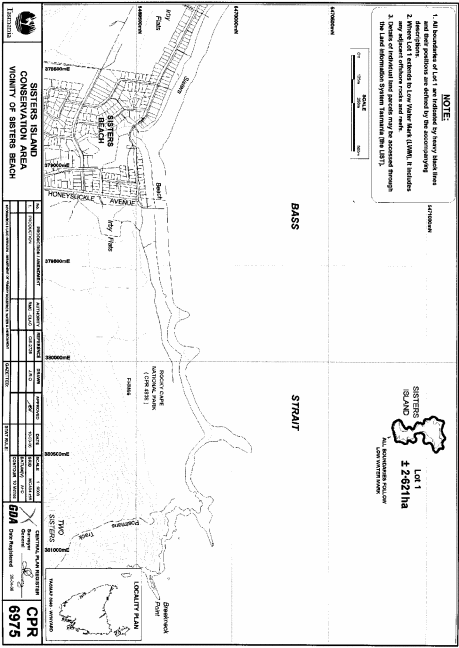
PART 25 - Sisters Island Conservation AreaAll that area of land comprising about 2.621 hectares, shown as Lot 1 and bounded by a heavy black line on Plan 6975 in the Central Plan Register, a reduced copy of which is set out, by way of illustration only, in Part 26 of Schedule 2 to this proclamation.
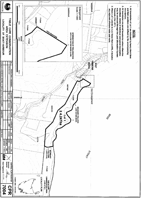
PART 26 - Table Cape Conservation AreaAll that area of land comprising about 4.247 hectares, shown as Lot 1 and bounded by a heavy black line on Plan 7004 in the Central Plan Register, a reduced copy of which is set out, by way of illustration only, in Part 27 of Schedule 2 to this proclamation.
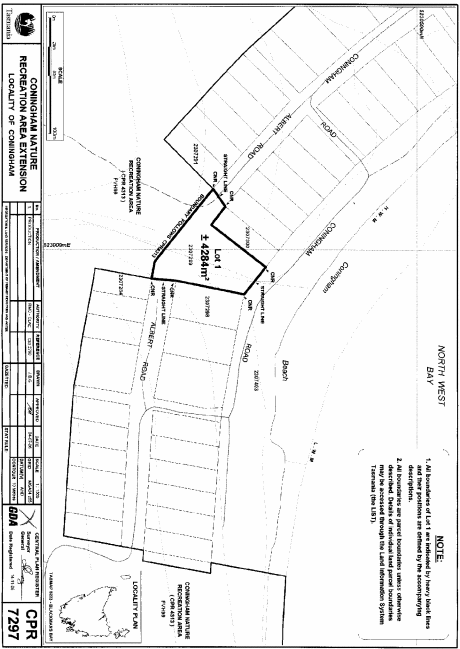
PART 27 - Coningham Nature Recreation AreaAll that area of land comprising about 4 284 square metres, shown as Lot 1 and bounded by a heavy black line on Plan 7297 in the Central Plan Register, a reduced copy of which is set out, by way of illustration only, in Part 28 of Schedule 2 to this proclamation.
PART 28 - Leven Canyon Regional Reserve
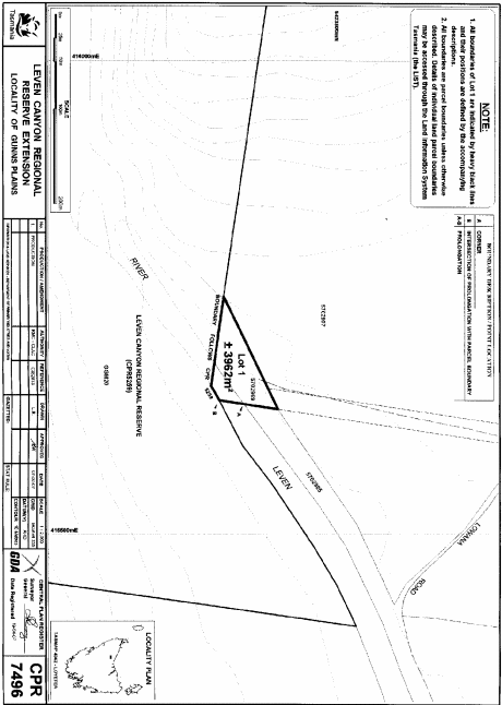
1. All that area of land comprising about 3 962 square metres, shown as Lot 1 and bounded by a heavy black line on Plan 7496 in the Central Plan Register, a reduced copy of which is set out, by way of illustration only, in Part 29 of Schedule 2 to this proclamation.
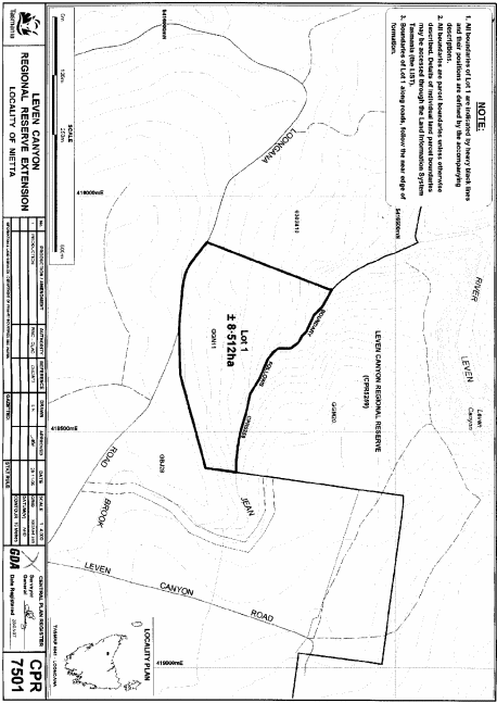
2. All that area of land comprising about 8.512 hectares, shown as Lot 1 and bounded by a heavy black line on Plan 7501 in the Central Plan Register, a reduced copy of which is set out, by way of illustration only, in Part 30 of Schedule 2 to this proclamation.
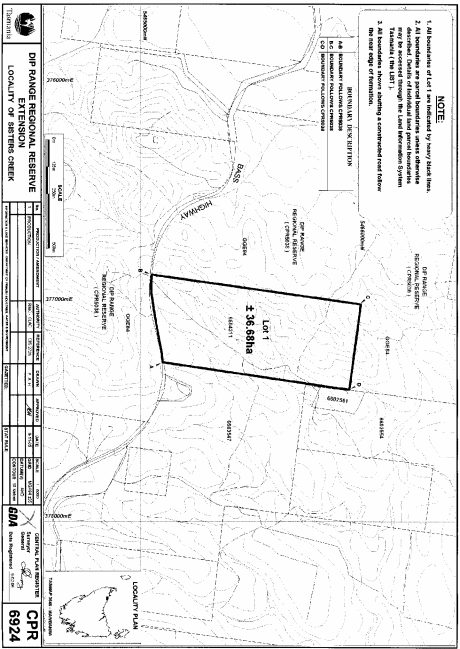
PART 29 - Dip Range Regional ReserveAll that area of land comprising about 36.68 hectares, shown as Lot 1 and bounded by a heavy black line on Plan 6924 in the Central Plan Register, a reduced copy of which is set out, by way of illustration only, in Part 31 of Schedule 2 to this proclamation.
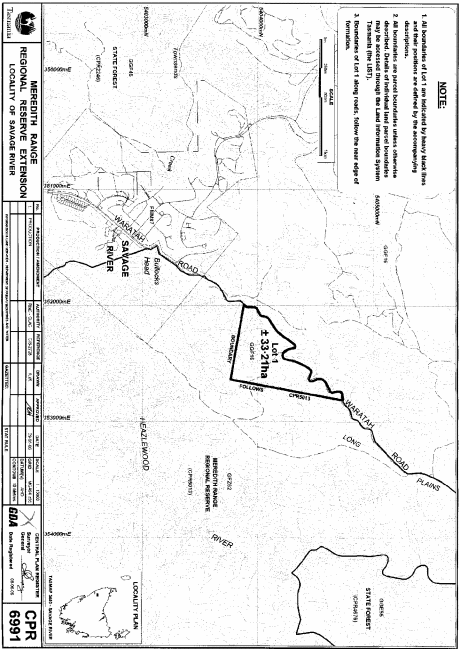
PART 30 - Meredith Range Regional ReserveAll that area of land comprising about 33.21 hectares, shown as Lot 1 and bounded by a heavy black line on Plan 6991 in the Central Plan Register, a reduced copy of which is set out, by way of illustration only, in Part 32 of Schedule 2 to this proclamation.
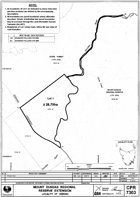
PART 31 - Mount Dundas Regional ReserveAll that area of land comprising about 26.79 hectares, shown as Lot 1 and bounded by a heavy black line on Plan 7303 in the Central Plan Register, a reduced copy of which is set out, by way of illustration only, in Part 33 of Schedule 2 to this proclamation.
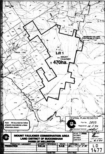
PART 32 - Mount Faulkner Conservation Area – Plan 2855All that area of land comprising about 470 hectares, shown as Lot 1 and bounded by a heavy black line on Plan 2855 in the Central Plan Register, a reduced copy of which is set out, by way of illustration only, in Part 34 of Schedule 2 to this proclamation.
SCHEDULE 2 - Plans
PART 1 - Petrel Islands Game Reserve
PART 2 - Stack Island Game Reserve
PART 3 - Actaeon Island Game Reserve
PART 4 - Tatlows Beach Conservation Area
PART 5 - Mount Faulkner Conservation Area – Plan 7370
PART 6 - Molesworth Conservation Area
PART 7 - Lillico Beach Conservation Area
PART 8 - Coles Bay Conservation Area – Plan 7503
PART 9 - Coles Bay Conservation Area – Plan 7505
PART 10 - Kelvedon Beach Conservation Area
PART 11 - Mayfield Bay Conservation Area
PART 12 - Swansea Conservation Area
PART 13 - Whalers Lookout Conservation Area
PART 14 - Pelican Island Conservation Area
PART 15 - Port Cygnet Conservation Area
PART 16 - Randalls Bay Conservation Area
PART 17 - Surveyors Bay Conservation Area
PART 18 - Cape De La Sortie Conservation Area
PART 19 - Fossil Cove Conservation Area
PART 20 - Mount Royal Conservation Area
PART 21 - Marion Beach Conservation Area
PART 22 - Lake Dulverton Conservation Area
PART 23 - Gravelly Ridge Conservation Area

PART 24 - Brother and Sister Conservation Area
PART 25 - Fossil Bluff Conservation Area
PART 26 - Sisters Island Conservation Area
PART 27 - Table Cape Conservation Area
PART 28 - Coningham Nature Recreation Area
PART 29 - Leven Canyon Regional Reserve – Plan 7496
PART 30 - Leven Canyon Regional Reserve – Plan 7501
PART 31 - Dip Range Regional Reserve
PART 32 - Meredith Range Regional Reserve
PART 33 - Mount Dundas Regional Reserve
PART 34 - Mount Faulkner Conservation Area – Plan 2855
Displayed and numbered in accordance with the Rules Publication Act 1953.
Notified in the Gazette on 12 December 2007
This proclamation is administered in the Department of Primary Industries and Water.