

Proclamation under the Nature Conservation Act 2002
I, the Lieutenant-Governor in and over the State of Tasmania and its Dependencies in the Commonwealth of Australia, acting with the advice of the Executive Council, by this my proclamation made under section 21(1) of the Nature Conservation Act 2002 declare –
28 July 2003(a) that the areas of Crown land specified in Part 1 of Schedule 1 to this proclamation, being areas of land within reserved land known as the Arthur-Pieman Conservation Area, cease to be part of that reserved land; and(b) that the area of Crown land specified in Part 2 of Schedule 1 to this proclamation, being an area of land within reserved land known as the Bay of Fires Conservation Area, ceases to be part of that reserved land; and(c) that the areas of Crown land specified in Part 3 of Schedule 1 to this proclamation, being areas of land within reserved land known as the Musselroe Bay Conservation Area, cease to be part of that reserved land; and(d) that the area of Crown land specified in Part 4 of Schedule 1 to this proclamation, being an area of land within reserved land known as the Port Sorell Conservation Area, ceases to be part of that reserved land; and(e) that the areas of Crown land specified in Part 5 of Schedule 1 to this proclamation, being areas of land within reserved land known as the Recherche Bay Nature Recreation Area, cease to be part of that reserved land; and(f) that the area of Crown land specified in Part 6 of Schedule 1 to this proclamation, being an area of land within reserved land known as the Rocky Cape National Park, ceases to be part of that reserved land; and(g) that the areas of Crown land specified in Part 7 of Schedule 1 to this proclamation, being areas of land within reserved land known as the Surveyors Bay Conservation Area, cease to be part of that reserved land; and(h) that the area of Crown land specified in Part 8 of Schedule 1 to this proclamation, being an area of land within reserved land known as the Tesselated Pavement State Reserve, ceases to be part of that reserved land; and(i) that this proclamation takes effect on the day on which its making is notified in the Gazette.
W. J. E. Cox
Lieutenant-Governor
By His Excellency's Command,
Bryan Green
Minister for Primary Industries, Water and Environment
SCHEDULE 1 - Revocations
PART 1 - Arthur-Pieman Conservation Area
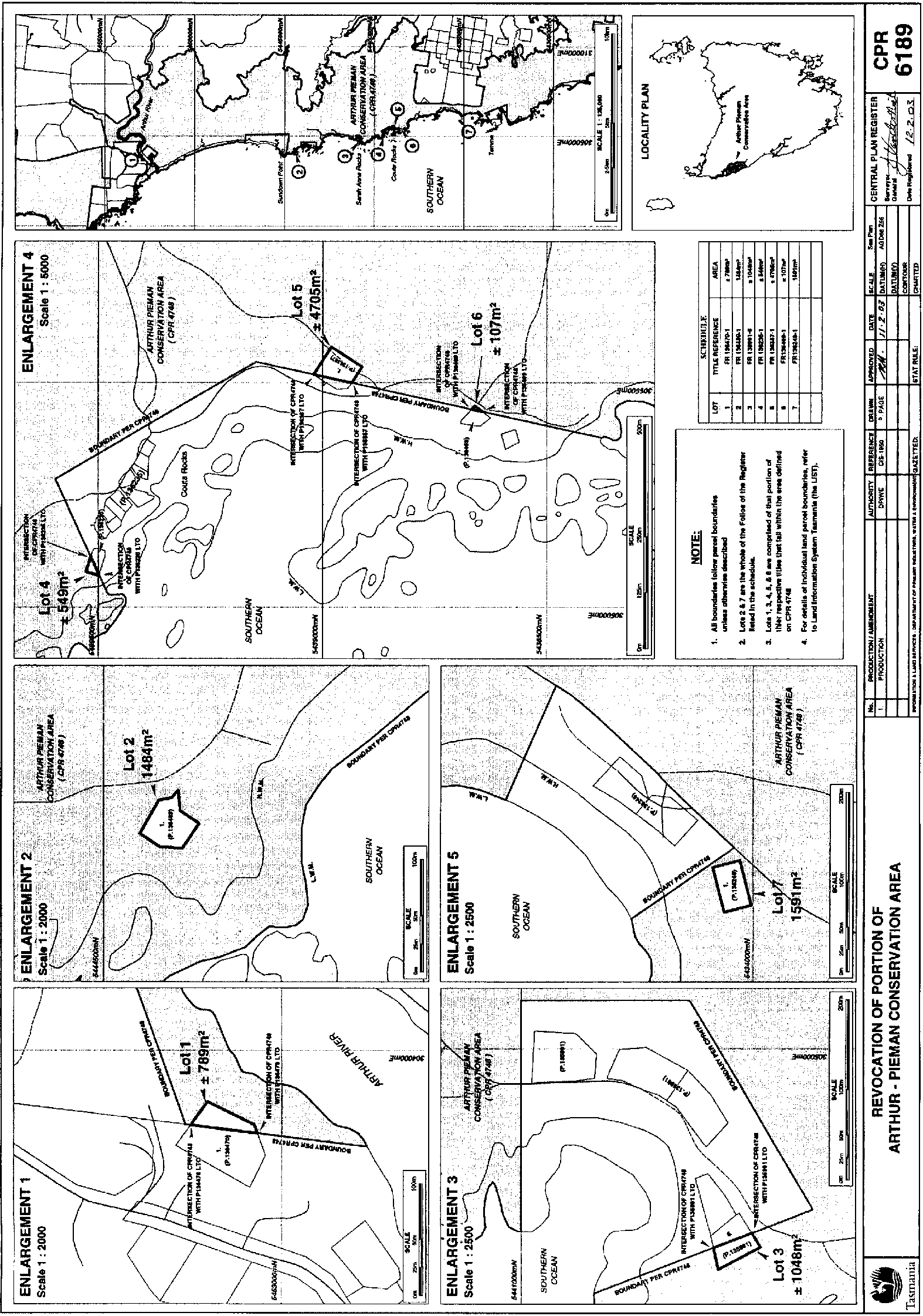
1. All those areas of land comprising –and bounded by heavy black lines on Plan 6189 in the Central Plan Register, a reduced copy of which is set out, by way of illustration only, in Part 1 of Schedule 2 to this proclamation.(a) about 789 square metres shown as Lot 1; and(b) about 1 484 square metres shown as Lot 2; and(c) about 1 048 square metres shown as Lot 3; and(d) about 549 square metres shown as Lot 4; and(e) about 4 705 square metres shown as Lot 5; and(f) about 107 square metres shown as Lot 6; and(g) about 1 591 square metres shown as Lot 7 –
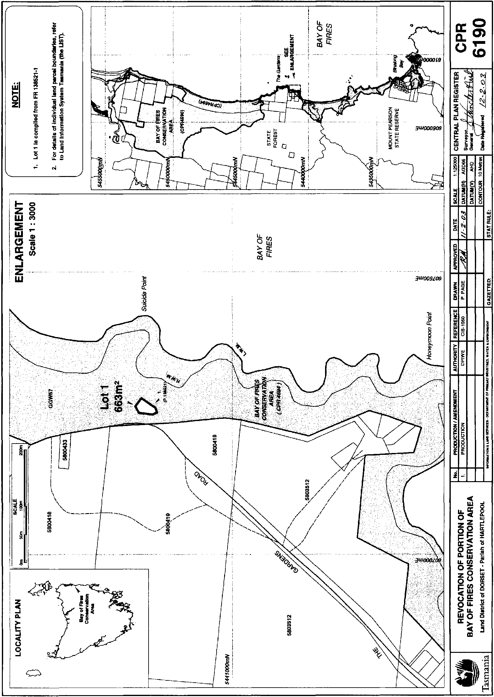
PART 2 - Bay of Fires Conservation AreaAll that area of land comprising about 663 square metres shown as Lot 1 and bounded by a heavy black line on Plan 6190 in the Central Plan Register, a reduced copy of which is set out, by way of illustration only, in Part 2 of Schedule 2 to this proclamation.
PART 3 - Musselroe Bay Conservation Area
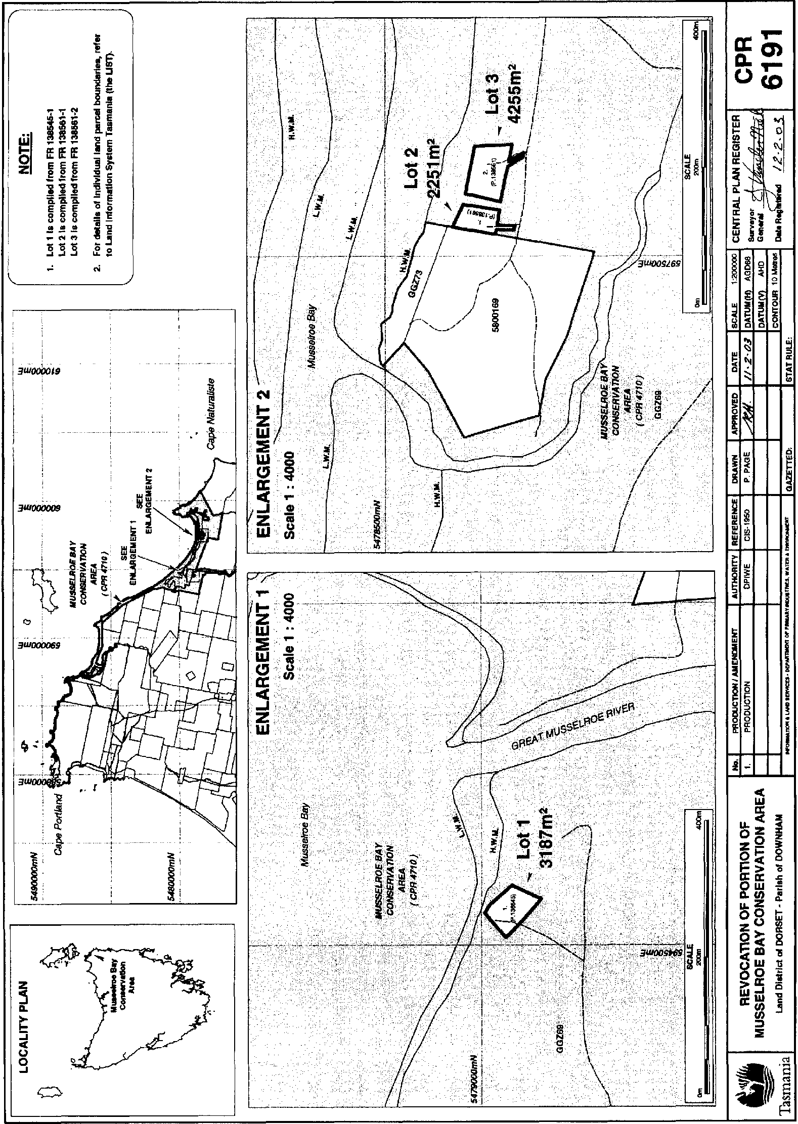
1. All those areas of land comprising –and bounded by heavy black lines on Plan 6191 in the Central Plan Register, a reduced copy of which is set out, by way of illustration only, in Part 3 of Schedule 2 to this proclamation.(a) about 3 187 square metres shown as Lot 1; and(b) about 2 251 square metres shown as Lot 2; and(c) about 4 255 square metres shown as Lot 3 –
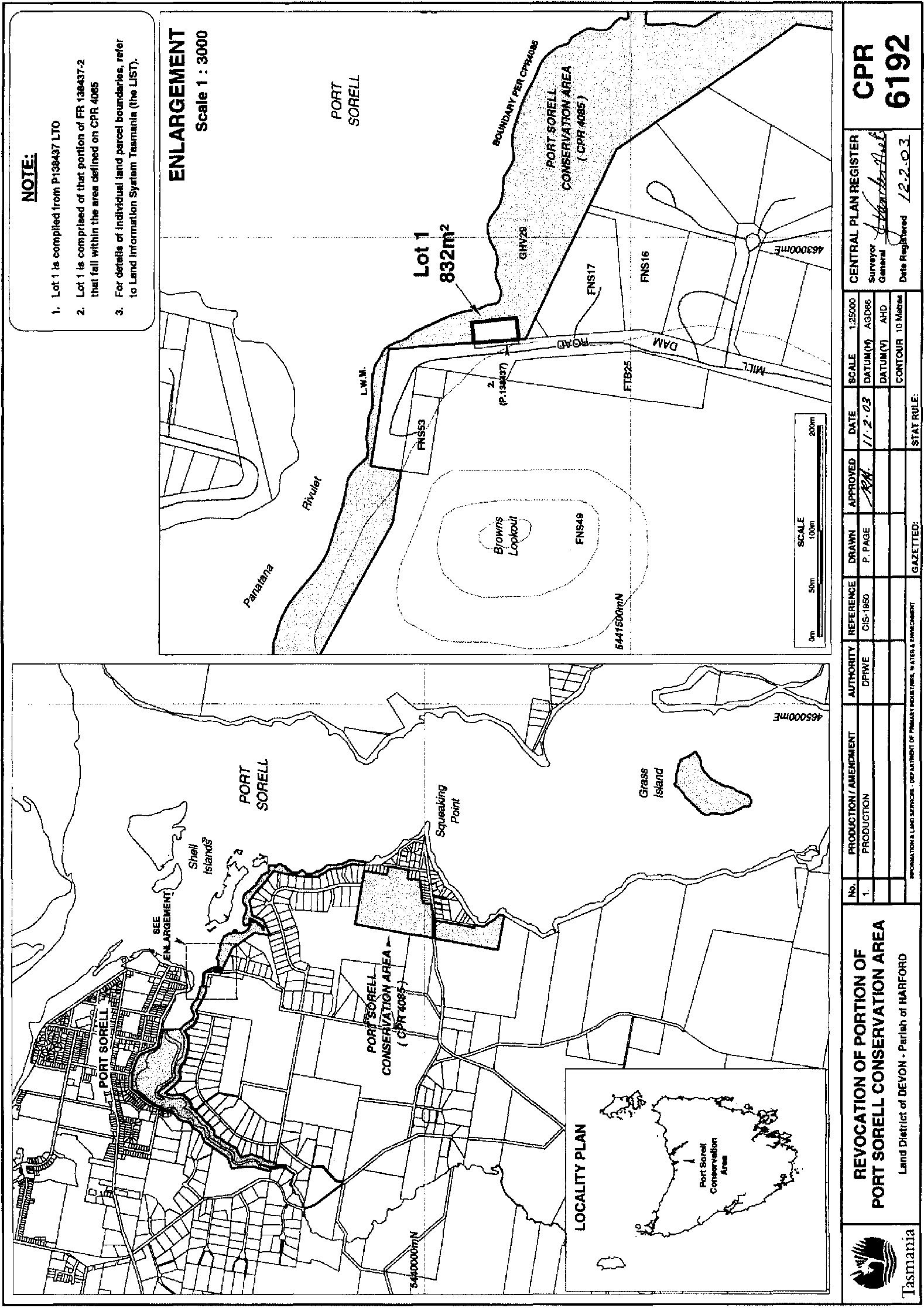
PART 4 - Port Sorell Conservation AreaAll that area of land comprising about 832 square metres shown as Lot 1 and bounded by a heavy black line on Plan 6192 in the Central Plan Register, a reduced copy of which is set out, by way of illustration only, in Part 4 of Schedule 2 to this proclamation.
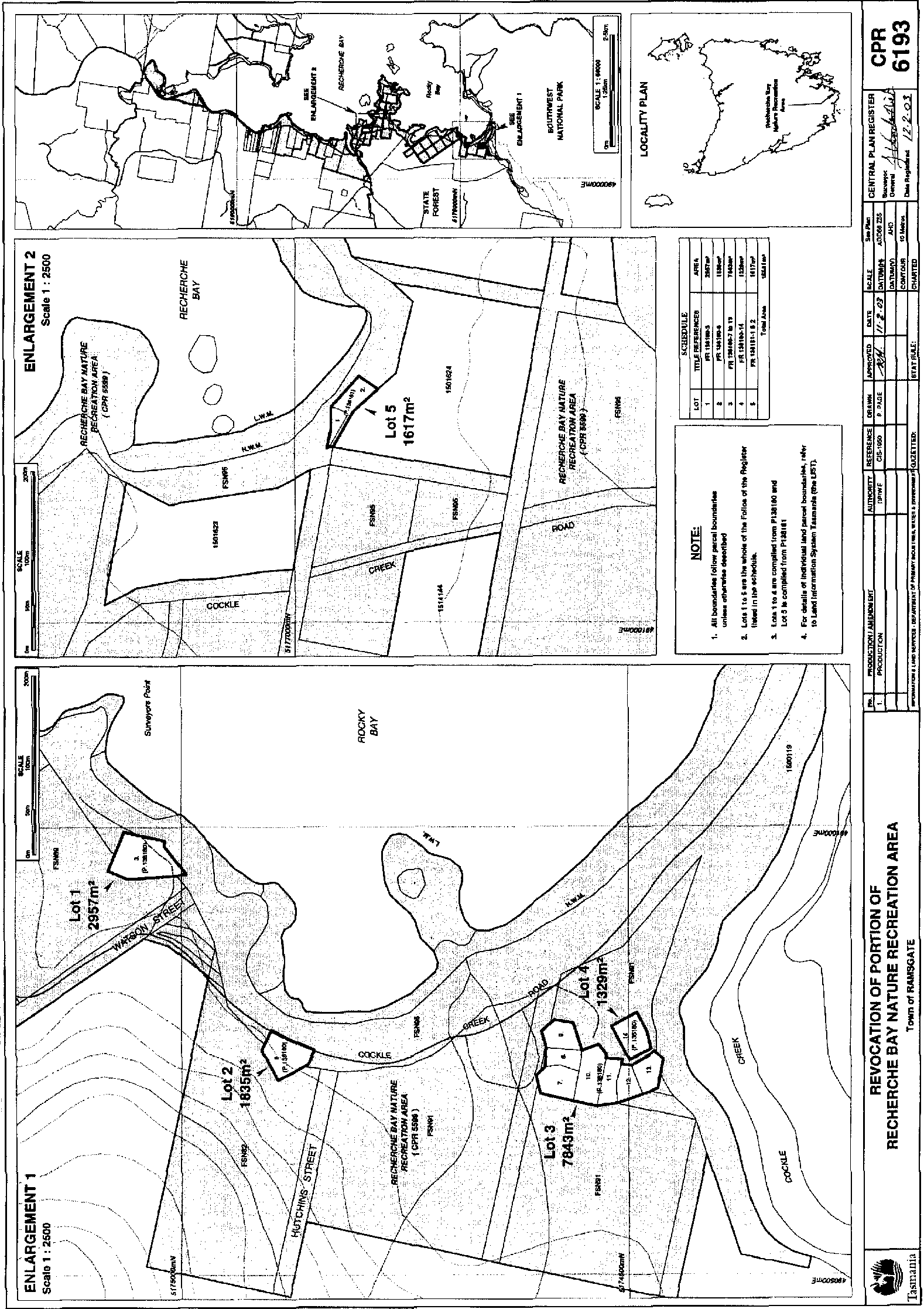
PART 5 - Recherche Bay Nature Recreation Area
1. All those areas of land comprising –and bounded by heavy black lines on Plan 6193 in the Central Plan Register, a reduced copy of which is set out, by way of illustration only, in Part 5 of Schedule 2 to this proclamation.(a) about 2 957 square metres shown as Lot 1; and(b) about 1 835 square metres shown as Lot 2; and(c) about 7 843 square metres shown as Lot 3; and(d) about 1 329 square metres shown as Lot 4; and(e) about 1 617 square metres shown as Lot 5 –
PART 6 - Rocky Cape National ParkAll that area of land comprising about 4.88 hectares shown as Lot 1 and bounded by a heavy black line on Plan 6194 in the Central Plan Register, a reduced copy of which is set out, by way of illustration only, in Part 6 of Schedule 2 to this proclamation.
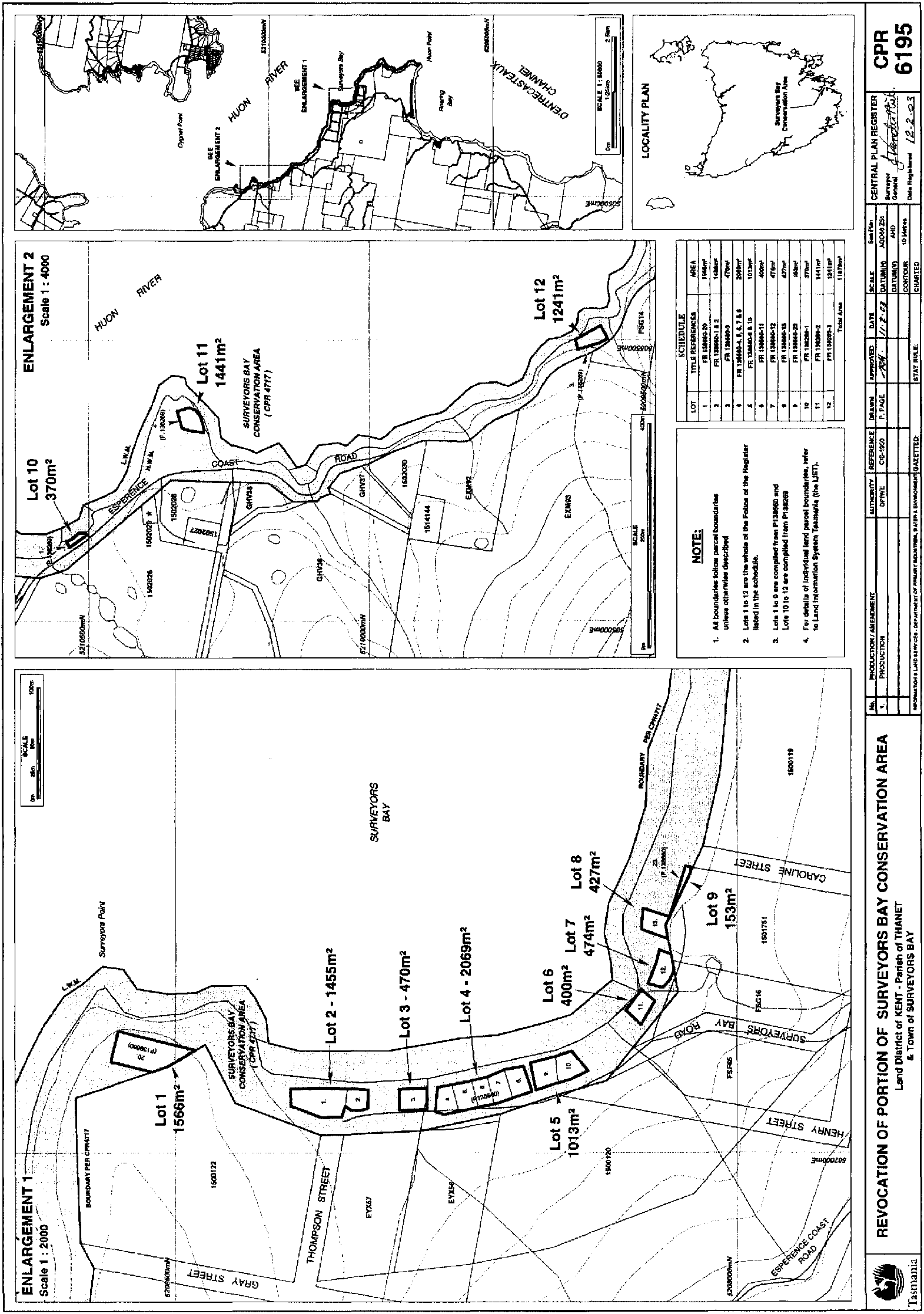
PART 7 - Surveyors Bay Conservation Area
1. All those areas of land comprising –and show bounded by heavy black lines on Plan 6195 in the Central Plan Register, a reduced copy of which is set out, by way of illustration only, in Part 7 of Schedule 2 to this proclamation.(a) about 1 566 square metres shown as Lot 1; and(b) about 1 455 square metres shown as Lot 2; and(c) about 470 square metres shown as Lot 3; and(d) about 2 069 square metres shown as Lot 4; and(e) about 1 013 square metres shown as Lot 5; and(f) about 400 square metres shown as Lot 6; and(g) about 474 square metres shown as Lot 7; and(h) about 427 square metres shown as Lot 8; and(i) about 153 square metres shown as Lot 9; and(j) about 370 square metres shown as Lot 10; and(k) about 1 441 square metres shown as Lot 11; and(l) about 1 241 square metres shown as Lot 12 –
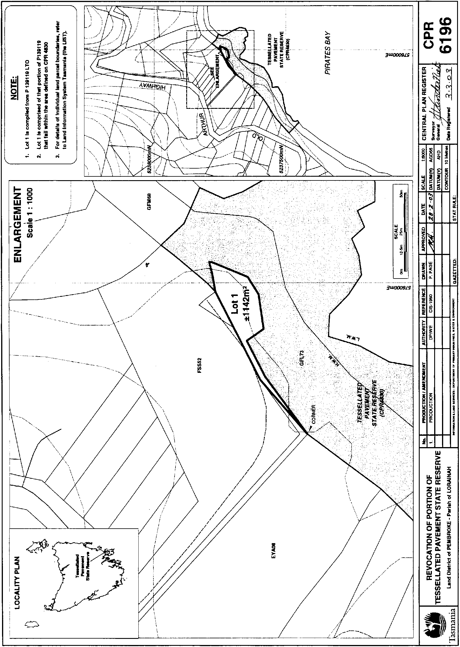
PART 8 - Tesselated Pavement State ReserveAll that area of land comprising about 1 142 square metres shown as Lot 1 and bounded by a heavy black line on Plan 6196 in the Central Plan Register, a reduced copy of which is set out, by way of illustration only, in Part 8 of Schedule 2 to this proclamation.
SCHEDULE 2 - Plans
PART 1 - Arthur-Pieman Conservation Area
PART 2 - Bay of Fires Conservation Area
PART 3 - Musselroe Bay Conservation Area
PART 4 - Port Sorell Conservation Area
PART 5 - Recherche Bay Nature Recreation Area
PART 6 - Rocky Cape National Park

PART 7 - Surveyors Bay Conservation Area
PART 8 - Tesselated Pavement State Reserve
Displayed and numbered in accordance with the Rules Publication Act 1953.
Notified in the Gazette on 6 August 2003
This proclamation is administered in the Department of Primary Industries, Water and Environment.