

Proclamation under the Nature Conservation Act 2002
I, the Governor in and over the State of Tasmania and its Dependencies in the Commonwealth of Australia, acting with the advice of the Executive Council, by this my proclamation made under section 11(2) of the Nature Conservation Act 2002 declare –
28 July 2008(a) the Crown land specified in Part 1 of Schedule 1 to this proclamation to be reserved land in the class of national park and give the name Cradle Mountain-Lake St Clair National Park to that reserved land; and(b) the Crown land specified in Part 2 of Schedule 1 to this proclamation to be reserved land in the class of national park and give the name Freycinet National Park to that reserved land; and(c) the Crown land specified in Part 3 of Schedule 1 to this proclamation to be reserved land in the class of national park and give the name Mole Creek Karst National Park to that reserved land; and(d) the Crown land specified in Part 4 of Schedule 1 to this proclamation to be reserved land in the class of State reserve and give the name Hellyer Gorge State Reserve to that reserved land; and(e) the Crown land specified in Part 5 of Schedule 1 to this proclamation to be reserved land in the class of State reserve and give the name Little Peggs Beach State Reserve to that reserved land; and(f) the Crown land specified in Part 6 of Schedule 1 to this proclamation to be reserved land in the class of State reserve and give the name Lookout Rock State Reserve to that reserved land; and(g) the Crown land specified in Part 7 of Schedule 1 to this proclamation to be reserved land in the class of State reserve and give the name Roger River State Reserve to that reserved land; and(h) the Crown land specified in Part 8 of Schedule 1 to this proclamation to be reserved land in the class of State reserve and give the name Tessellated Pavement State Reserve to that reserved land; and(i) the Crown land specified in Part 9 of Schedule 1 to this proclamation to be reserved land in the class of State reserve and give the name The Nut State Reserve to that reserved land; and(j) the Crown land specified in Part 10 of Schedule 1 to this proclamation to be reserved land in the class of State reserve and give the name Three Hummock Island State Reserve to that reserved land; and(k) the Crown land specified in Part 11 of Schedule 1 to this proclamation to be reserved land in the class of State reserve and give the name Wye River State Reserve to that reserved land; and(l) the Crown land specified in Part 12 of Schedule 1 to this proclamation to be reserved land in the class of nature reserve and give the name Councillor Island Nature Reserve to that reserved land; and(m) the Crown land specified in Part 13 of Schedule 1 to this proclamation to be reserved land in the class of nature reserve and give the name Huntingdon Nature Reserve to that reserved land; and(n) the Crown land specified in Part 14 of Schedule 1 to this proclamation to be reserved land in the class of nature reserve and give the name Pitt Water Nature Reserve to that reserved land; and(o) the Crown land specified in Part 15 of Schedule 1 to this proclamation to be reserved land in the class of nature reserve and give the name Tinderbox Marine Nature Reserve to that reserved land; and(p) that this proclamation takes effect on the day on which its making is notified in the Gazette.
PETER G. UNDERWOOD
Governor
By His Excellency's Command,
D. E. LLEWELLYN
Minister for Primary Industries and Water
SCHEDULE 1 - Areas of land
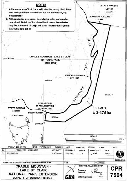
PART 1 - Cradle Mountain-Lake St Clair National ParkAll that area of land comprising about 2.475 hectares, shown as Lot 1 and bounded by a heavy black line on Plan 7504 in the Central Plan Register, a reduced copy of which is set out, by way of illustration only, in Part 1 of Schedule 2 to this proclamation.
PART 2 - Freycinet National ParkAll those areas of land comprising –
and bounded by heavy black lines on Plan 7510 in the Central Plan Register, a reduced copy of which is set out, by way of illustration only, in Part 2 of Schedule 2 to this proclamation.(a) about 4.109 hectares, shown as Lot 1; and(b) about 2.542 hectares, shown as Lot 2; and(c) about 4.162 hectares, shown as Lot 3 –
PART 3 - Mole Creek Karst National Park
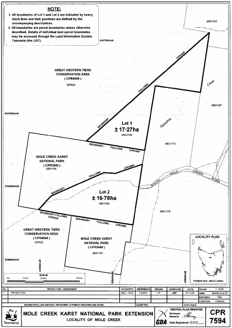
1. All those areas of land comprising –and bounded by heavy black lines on Plan 7594 in the Central Plan Register, a reduced copy of which is set out, by way of illustration only, in Part 3 of Schedule 2 to this proclamation.(a) about 17.27 hectares, shown as Lot 1; and(b) about 16.78 hectares, shown as Lot 2 –
2. All that area of land comprising about 8.566 hectares, shown as Lot 1 and bounded by a heavy black line on Plan 7595 in the Central Plan Register, a reduced copy of which is set out, by way of illustration only, in Part 4 of Schedule 2 to this proclamation.
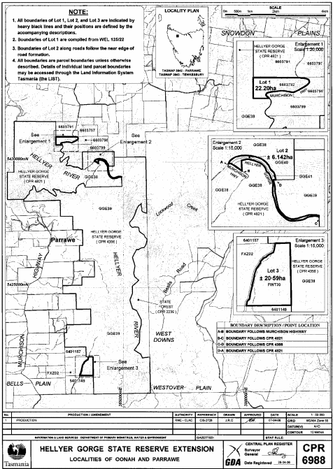
PART 4 - Hellyer Gorge State ReserveAll those areas of land comprising –
and bounded by heavy black lines on Plan 6988 in the Central Plan Register, a reduced copy of which is set out, by way of illustration only, in Part 5 of Schedule 2 to this proclamation.(a) about 22.2 hectares, shown as Lot 1; and(b) about 6.142 hectares, shown as Lot 2; and(c) about 20.59 hectares, shown as Lot 3 –
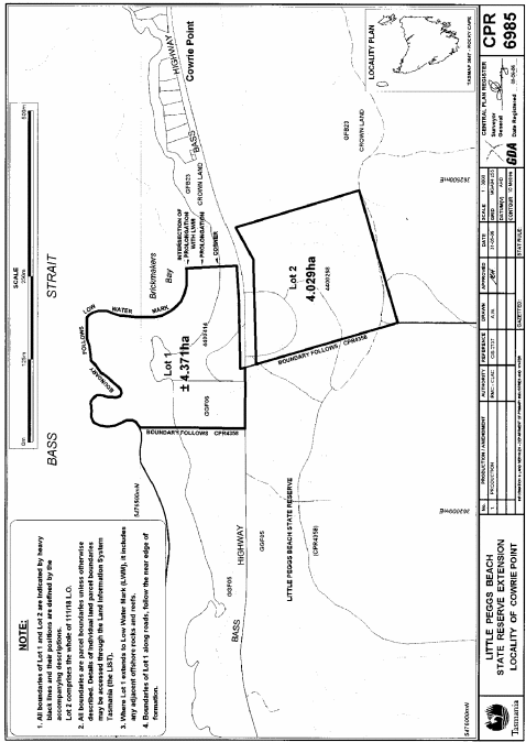
PART 5 - Little Peggs Beach State ReserveAll those areas of land comprising –
and bounded by heavy black lines on Plan 6985 in the Central Plan Register, a reduced copy of which is set out, by way of illustration only, in Part 6 of Schedule 2 to this proclamation.(a) about 4.371 hectares, shown as Lot 1; and(b) about 4.029 hectares, shown as Lot 2 –
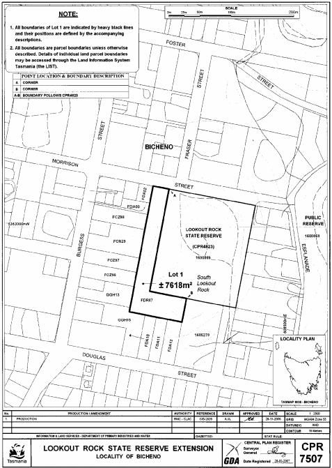
PART 6 - Lookout Rock State ReserveAll that area of land comprising about 7 618 square metres, shown as Lot 1 and bounded by a heavy black line on Plan 7507 in the Central Plan Register, a reduced copy of which is set out, by way of illustration only, in Part 7 of Schedule 2 to this proclamation.
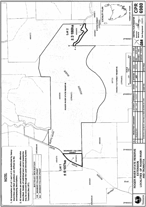
PART 7 - Roger River State ReserveAll those areas of land comprising –
and bounded by heavy black lines on Plan 6980 in the Central Plan Register, a reduced copy of which is set out, by way of illustration only, in Part 8 of Schedule 2 to this proclamation.(a) about 5.107 hectares, shown as Lot 1; and(b) 2.180 hectares, shown as Lot 2 –
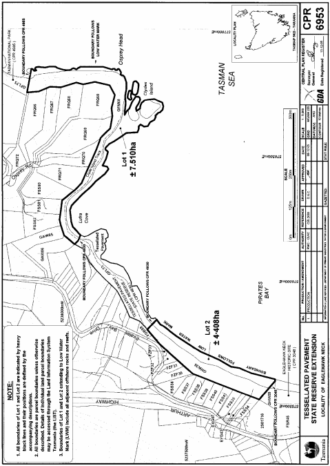
PART 8 - Tessellated Pavement State ReserveAll those areas of land comprising –
and bounded by heavy black lines on Plan 6953 in the Central Plan Register, a reduced copy of which is set out, by way of illustration only, in Part 9 of Schedule 2 to this proclamation.(a) about 7.51 hectares, shown as Lot 1; and(b) about 4.408 hectares, shown as Lot 2 –
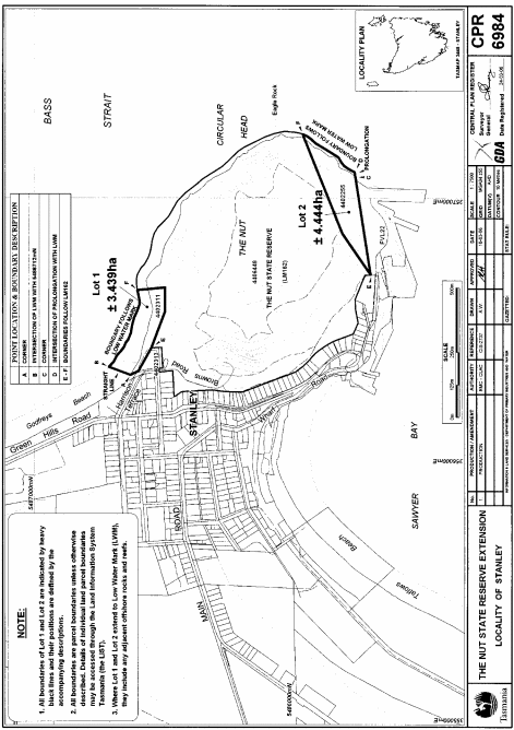
PART 9 - The Nut State ReserveAll those areas of land comprising –
and bounded by heavy black lines on Plan 6984 in the Central Plan Register, a reduced copy of which is set out, by way of illustration only, in Part 10 of Schedule 2 to this proclamation.(a) about 3.439 hectares, shown as Lot 1; and(b) about 4.444 hectares, shown as Lot 2 –
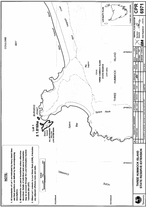
PART 10 - Three Hummock Island State ReserveAll those areas of land comprising about 1.816 hectares, shown as Lot 1 and bounded by heavy black lines on Plan 6971 in the Central Plan Register, a reduced copy of which is set out, by way of illustration only, in Part 11 of Schedule 2 to this proclamation.
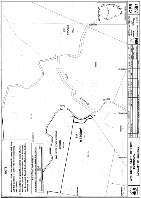
PART 11 - Wye River State ReserveAll that area of land comprising about 8 300 square metres, shown as Lot 1 and bounded by a heavy black line on Plan 7591 in the Central Plan Register, a reduced copy of which is set out, by way of illustration only, in Part 12 of Schedule 2 to this proclamation.
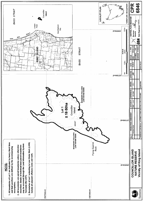
PART 12 - Councillor Island Nature ReserveAll those areas of land comprising about 18.50 hectares, shown as Lot 1 and being 2 separate areas each bounded by a heavy black line on Plan 6846 in the Central Plan Register, a reduced copy of which is set out, by way of illustration only, in Part 13 of Schedule 2 to this proclamation.
PART 13 - Huntingdon Nature ReserveAll that area of land comprising about 4 347 square metres, shown as Lot 1 and bounded by a heavy black line on Plan 7348 in the Central Plan Register, a reduced copy of which is set out, by way of illustration only, in Part 14 of Schedule 2 to this proclamation.
PART 14 - Pitt Water Nature ReserveAll those areas of land comprising –
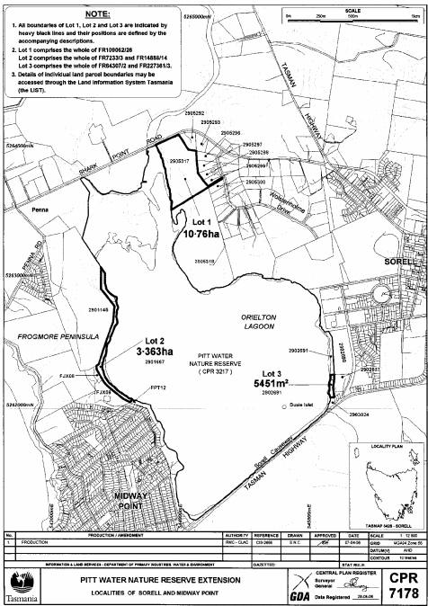
and bounded by heavy black lines on Plan 7178 in the Central Plan Register, a reduced copy of which is set out, by way of illustration only, in Part 15 of Schedule 2 to this proclamation.(a) about 10.76 hectares, shown as Lot 1; and(b) about 3.363 hectares, shown as Lot 2; and(c) about 5 451 square metres, shown as Lot 3 –
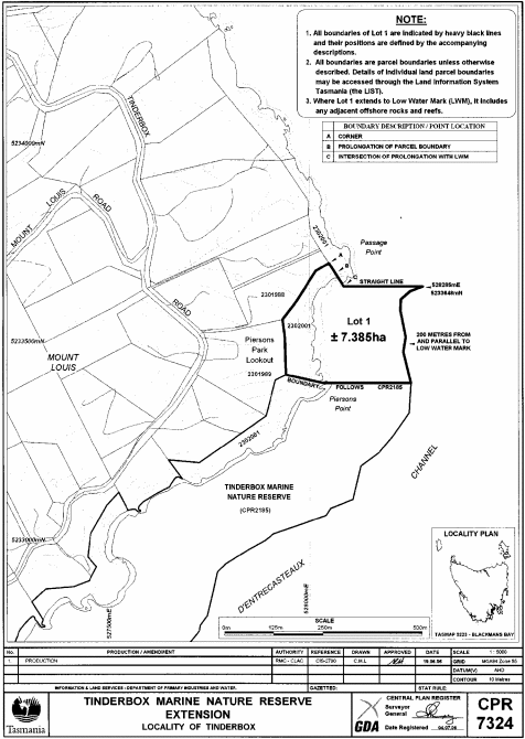
PART 15 - Tinderbox Marine Nature ReserveAll that area of land comprising about 7.385 hectares, shown as Lot 1 and bounded by a heavy black line on Plan 7324 in the Central Plan Register, a reduced copy of which is set out, by way of illustration only, in Part 16 of Schedule 2 to this proclamation.
SCHEDULE 2 - Plans
PART 1 - Cradle Mountain-Lake St Clair National Park
PART 2 - Freycinet National Park

PART 3 - Mole Creek Karst National Park – Plan 7594
PART 4 - Mole Creek Karst National Park – Plan 7595

PART 5 - Hellyer Gorge State Reserve
PART 6 - Little Peggs Beach State Reserve
PART 7 - Lookout Rock State Reserve
PART 8 - Roger River State Reserve
PART 9 - Tessellated Pavement State Reserve
PART 10 - The Nut State Reserve
PART 11 - Three Hummock Island State Reserve
PART 12 - Wye River State Reserve
PART 13 - Councillor Island Nature Reserve
PART 14 - Huntingdon Nature Reserve

PART 15 - Pitt Water Nature Reserve
PART 16 - Tinderbox Marine Nature Reserve
Displayed and numbered in accordance with the Rules Publication Act 1953.
Notified in the Gazette on 6 August 2008
This proclamation is administered in the Department of Primary Industries and Water.