

Proclamation under the Roads and Jetties Act 1935
I, the Governor in and over the State of Tasmania and its Dependencies in the Commonwealth of Australia, acting with the advice of the Executive Council, by this my proclamation made under section 7 of the Roads and Jetties Act 1935 –
18 December 2018(a) declare the portions of roads specified in Schedule 1 to this proclamation to be State highways for the purposes of Part II of that Act; and(b) declare the portions of roads specified in Schedule 2 to this proclamation to be a single subsidiary road, classified as a main road, for the purposes of Part II of that Act; and(c) amend the proclamation notified in the Gazette as Statutory Rules 1970, No.67 as follows:(i) by omitting from the First Schedule to that proclamation the item relating to the Brooker Highway and substituting the following item:
Brooker Highway
From the intersection with the Tasman Highway to the Midland Highway at, and including, the intersection with the Lyell Highway, Granton
11.48
(18.48 kilometres)
(ii) by omitting from the First Schedule to that proclamation the item relating to the Southern Outlet Highway and substituting the following item:
Southern Outlet Highway
From the intersection with the southern boundary of the Davey/Macquarie Couplet, South Hobart to and including the Kingston Interchange
5.95
(9.582 kilometres)
(iii) by omitting from the First Schedule to that proclamation the item relating to the Tasman Highway and substituting the following item:
Tasman Highway
From the intersection with the northern boundary of the Davey/Macquarie Couplet to the railway reserve (eastern boundary) at the crossing near Hoblers Bridge, Newstead, via the Tasman Bridge, Sorell, Orford, Swansea, St Helens, Derby, Scottsdale and Nunamara
255.35
(410.945 kilometres)
(iv) by inserting into Part I of the Second Schedule to that proclamation, in the correct alphabetical position, the following item:
Davey/Macquarie Couplet
The specified portions of the following roads:
2.65
(in total)
(4.266 kilometres)
(a) Davey Street, from the point where it intersects with the Tasman Highway to a point approximately 119 metres east of the centreline of Elboden Street, South Hobart (2.142 kilometres)
(b) the Southern Outlet, from the point where it intersects with Davey Street, South Hobart to the point where it intersects with Macquarie Street, South Hobart (0.080 kilometres)
(c) Macquarie Street, from a point approximately 99 metres west of the centreline of Gore Street, South Hobart to the point where it intersects with the junction of the Tasman Highway and the Brooker Highway (2.044 kilometres)
C. WARNER
Governor
By Her Excellency's Command,
JEREMY ROCKLIFF
Minister for Infrastructure
SCHEDULE 1 - Road portions declared to be a State highway
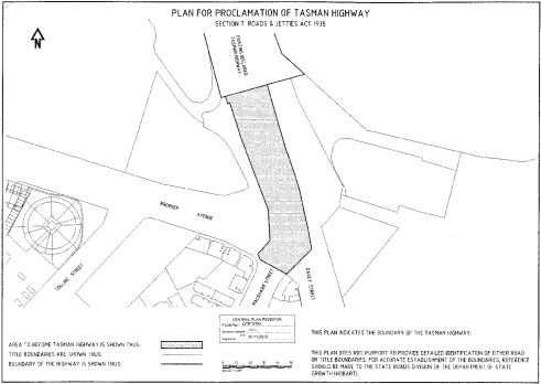
Name | Extent | Length in kilometres | 1. | Brooker Avenue | From its intersection with the Tasman Highway to its intersection with the existing State highway known as the Brooker Highway at the north-western boundary of Burnett Street, North Hobart | 1.224 | 2. | Southern Outlet | From its intersection with the southern boundary of Davey Street, South Hobart to a point 22 metres south of the southern boundary of that street | 0.022 | 3. | Tasman Highway | From its intersection with Davey Street and Macquarie Street to its intersection with the existing State highway known as the Tasman Highway at the ABC access road (northern boundary), the boundaries of which portion are shown shaded and bounded by heavy black lines on Plan. No. CPR10783 in the Central Plan Register, a copy of which is set out, by way of illustration only, in Schedule 3 to this order | 0.135 |
SCHEDULE 2 - Road portions declared to be a subsidiary road
Name | Extent | Length in kilometres | 1. | Davey Street | From its intersection with the Tasman Highway near the Cenotaph to a point approximately 119 metres east of the centreline of Elboden Street, South Hobart | 2.142 | 2. | Southern Outlet | From its intersection with Davey Street, South Hobart to its intersection with Macquarie Street, South Hobart | 0.080 | 3. | Macquarie Street | From a point approximately 99 metres west of the centreline of Gore Street, South Hobart to its intersection with the Tasman Highway near the Cenotaph | 2.044 |
SCHEDULE 3 - Plan
Displayed and numbered in accordance with the Rules Publication Act 1953.
Notified in the Gazette on 26 December 2018
This proclamation is administered in the Department of State Growth.